En vue de l'obtention du
DOCTORAT DE L'UNIVERSITÉ DE TOULOUSE
Délivré par :
Institut National Polytechnique de Toulouse (INP Toulouse)
Discipline ou spécialité :
Réseaux, Télécommunications, Systèmes et Architecture
Présentée et soutenue par :
Mme XIAOYAN MA
le lundi 6 novembre 2017
Titre :
Unité de recherche :
Ecole doctorale :
Data Collection of Mobile Sensor Networks by Drones
Mathématiques, Informatique, Télécommunications de Toulouse (MITT)
Institut de Recherche en Informatique de Toulouse (I.R.I.T.)
Directeur(s) de Thèse :
M. RIADH DHAOU M. RAHIM KACIMI
Rapporteurs :
Mme HOUDA LABIOD, TELECOM PARISTECH
M. SIDI MOHAMMED SENOUCI, UNIVERSITE DE BOURGOGNE
Membre(s) du jury :
Mme VÉRONIQUE VEQUE, UNIVERSITE PARIS 11, Président M. ANDRE LUC BEYLOT, INP TOULOUSE, Membre M. MICHEL MAROT, TELECOM SUD PARIS, Membre M. RAHIM KACIMI, UNIVERSITE TOULOUSE 3, Membre
Acknowledgment
I’m indebted to numerous people who have helped me in understanding this research field and in writing this thesis. A prominent place and heartfelt thanks are owed to my two supervisors at the Institut de Recherche en Informatique de Toulouse (IRIT) group, Prof. Riadh DHAOU and Prof. Rahim KACIMI. They encouraged me to learn the wireless sensor network from the foundation. And they provide me research discussion seminars at least one time each week. Meanwhile, they also provide me suggestions via email, phone, meeting whenever I meet problems in my study. They help me write the thesis and correct it word by word. Also, I’m grateful to many colleagues with whom I had the pleasure and the privilege to discuss sensor network research issues, especially Prof. André-Luc BEYLOT. I am honored to have the opportunity to take part in the group seminars that organized by him, and he provide me lot of ideas on my research field. Prof. Houda LABIOD from TELECOM ParisTech and Prof. Sidi Mohammed SENOUCI from université de Bourgogne did an excellent job in proofreading and criticizing an intermediate version of this thesis. Prof. Michel MAROT from TELECOM Sud-Paris and Prof. Véronique VEQUE from Université de Paris-Sud provided me with many useful comments.
I’m also want to express my deep gratitude to all the researchers in the field who have made their results and publications easily available over the World Wide Web. Without this, collecting the material discussed in the thesis would have been too big a challenge to embark on.
And last, but most importantly, I’m very deeply indebted to my family for bearing with me during the writing of thesis, hoping, and working.
Resume
La collecte de données par des réseaux de capteurs autonomes mobiles peut être couplée à l’utilisation de drones qui constituent une solution de backahauling facilement déployable à faible coût. Ces moyens de collecte peuvent servir lors de l’organisation d’évènements temporaires (sportifs ou culturels) ou encore pour mener des opérations dans des terrains difficiles d’accès ou hostiles. L’objectif de cette thèse est de proposer des solutions efficaces pour la communication à la fois entre capteurs mobiles au sol et sur la liaison bord-sol. A ces fins, nous nous intéressons à l’ordonnancement des communications, au routage et au contrôle de l’accès sur la liaison capteurs/drone, le collecteur mobile. Nous proposons une architecture répondant aux contraintes du réseau. Les principales sont l’intermittence des liens et donc le manque de connexité pour lesquelles des solutions adaptées aux réseaux tolérants aux délais sont adoptées. Vu la limitation des opportunités de communication avec le drone et la variation importante du débit physique, nous avons proposés des solutions d’ordonnancement qui tiennent compte à la fois des durées de contact que du débit physique. Le routage opportuniste est également fondé sur ces deux critères à la fois pour la sélection des nœuds relais que pour la gestion des files d’attente. Nous avons souhaité limiter l’overhead et proposer des solutions efficaces et équitables entre capteurs mobiles au sol. Les solutions proposées ont montré leur supériorité par rapport aux solutions d’ordonnancement et de routage classiques. Nous avons enfin, proposé une méthode d’accès combinant un accès aléatoire avec contention ainsi qu’un accès avec réservation tenant compte des critères précédemment cités. Cette solution flexible permet à un réseau de capteurs mobiles denses de se rapprocher des performances obtenues dans un mode oracle. Les solutions proposées peuvent être mises en œuvre et appliquées dans différents contextes applicatifs pour lesquels les nœuds au sol sont mobiles ou aisément adaptées au cas où les nœuds sont statiques.
Abstract
Data collection by autonomous mobile sensor arrays can be coupled with the use of drones which provide a low-cost, easily deployable backhauling solution. These means of collection can be used to organize temporary events (sporting or cultural) or to carry out operations in difficult or hostile terrain. The aim of this thesis is to propose effective solutions for communication between both mobile sensors on the ground and on the edge-to-ground link. For this purpose, we are interested in scheduling communications, routing and access control on the sensor / drone link, the mobile collector. We propose an architecture that meets the constraints of the network. The main ones are the intermittence of the links and therefore the lack of connectivity for which solutions adapted to the networks tolerant to the deadlines are adopted. Given the limited opportunities for communication with the drone and the significant variation in the physical data rate, we proposed scheduling solutions that take account of both the contact time and the physical flow rate. Opportunistic routing is also based on these two criteria both for the selection of relay nodes and for the management of queues. We wanted to limit the overhead and propose efficient and fair solutions between mobile sensors on the ground. The proposed solutions have proved superior to conventional scheduling and routing solutions. Finally, we proposed a method of access combining a random access with contention as well as an access with reservation taking into account the aforementioned criteria. This flexible solution allows a network of dense mobile sensors to get closer to the performance obtained in an oracle mode. The proposed solutions can be implemented and applied in different application contexts for which the ground nodes are mobile or easily adapted to the case where the nodes are static.
Abbreviations and notations
Abbreviations
AD-PS MAC Adaptive inter-beacon duration and proactive scheduling MAC protocol
AHC Average hop count
AL Average latency
ANOR All node opportunistic routing algorithm
BOP Beacon only period
CBP Contention based period
CDT Contact duration time algorithm
CDT/DR Contact duration time/Data-rate algorithm
CFP Contention free period
CSMA Carrier Sense Multiple Access
DR Data-rate algorithm
DR/CDT Data-rate/Contact duration time algorithm
DTN Delay-tolerant networking
FANET Flying ad hoc network
FD-PS MAC Fixed inter-beacon duration and proactive scheduling MAC protocol
F-SS Communication between forwarders and simple nodes
HVOR Highest velocity opportunistic routing algorithm
IBD Inter-beacon duration
MAC Medium Access Control
PGT Periodically generated traffic
PRR Packet received ratio
RGT Randomly generated traffic
ROR Routing overhead ratio
SCH Scheduling information
TC Transmission capacity
TOCC Transmission with opportunistic competition capacity algorithm
UAV Unmanned aerial vehicle
UAV-F Communication between UAV and forwarders
VANET Vehicular ad hoc network
WSN Wireless sensor network
Notations
F The set of forwarders
S The set of sensors
T The set of time slots
G The set of simple nodes
V The set of sensors velocities
Sti The set of sensors that within the range of the UAV in time slot ti
α The duration time of one time slot
d(U, Si) The distance between UAV and sensor Si(Si ∈ S)
d(Sk, Si) The distance between the sensor Sk and Si (Sk, Si∈ S)
Dr(j) The data-rate of level j (j = 1, 2, 3, 4)
Dr(j, i) The data rate between sensor Si (Si ∈ S) and the UAV within time slot tj
(tj ∈ T)
h The fly height of the UAV
N The number of mobile sensors
Ns The number of sensors that send at least one packet in time T ;
Nts The number of time slots
Npk(i) The number of packets that the UAV has collected from sensor Si(Si ∈ S) in
time T
Nts(i) The number of time-slots allocated to sensor Si (Si∈ S) within T
N pk(j, i) The number of packets collected by the UAV from sensor Si(Si ∈ S) within
time-slot tj (tj ∈ T)
N tss(j, i) N tss(j, i) = 1 means that time slot tj (tj ∈ T) is allocated to sensor Si
(Si∈ S)
Pd The total number of packets delivered in time T
Pg The total number of packets that are generated in time T
Pr The total number of relayed packets
P k_Ge(i, j) The number of packets generated by sensor Sj(Sj ∈ S) till time-slot ti(ti ∈ T)
∈ F) successfully sent to the UAV P k_Sum(i) The sum of packets that Si has
r The communication range of the UAV and the mobile sensors
Si(xitk, yitk) The coordinates of sensor Si(Si ∈ S) in time slot tk(tk∈ T)
T The simulation time
Ticdt The contact duration time of sensor Si (Si∈ S) when it is within the
commu-nication range of the UAV
Tk−CBP The contention based period in k − th inter-beacon duration
Tk−CF P The contention free period in k − th inter-beacon duration
TU bd The upper bound of inter-beacon duration
v The velocity of the UAV
vi The velocity of the mobile sensor Si(Si ∈ S)
wi The weight of contact duration time of sensor Si (Si ∈ S)
W Fpk The weighted fairness in terms of the number of collected packets
W Fts The weighted fairness in terms of the number of allocated time slots
iii v vii ix
Table
of contents
Acknowledgment Resume AbstractAbbreviations and notations
1 Introduction 1
1.1 Context . . . . 2
1.2 Motivation and Assumptions . . . . 3
1.3 Contributions . . . . 4
5 1.4 Structure of the Thesis . . . . 2 State of Art 7 2.1 Introduction . . . . 8
2.2 Wireless Sensor Networks . . . . 8
2.2.1 Categories of sensors . . . . 9
2.2.2 Heterogeneous WSN . . . . 10
2.3 Unmanned Aerial Vehicles . . . . 11
2.3.1 Categorizes of the UAV . . . . 11
2.3.2 Fling Ad-Hoc Network (FANET) . . . . 12 xiii
2.4 Unmanned Aerial Vehicles as a Communication Node . . . . 15
2.4.1 Functionalities . . . . 16
2.4.2 Trajectory planning and placement . . . . 18
2.5 Data Collection Applications . . . . 20
2.5.1 Performance Parameters . . . . 21
2.5.2 Classification of the Data Collection Underlying Protocols . . . . 22
2.6 Underlying Layers for UAV assisted Networks . . . . 23
2.6.1 Routing Protocols . . . . 23
2.6.2 Medium Access Control Protocols . . . . 31
3 Scheduling Algorithms in Mobile Wireless Sensor Networks 37 3.1 State of Art . . . . 40
3.2 Problem Statement . . . . 41
3.3 Scheduling Algorithms . . . . 43
3.3.1 Analysis of influencing factors . . . . 43
3.3.2 Proposed Algorithms . . . . 47
3.4 Performance Evaluation . . . . 49
3.4.1 Performance Metrics . . . . 50
3.4.2 Simulation Results and Discussion . . . . 52
58 3.5 Conclusion . . . . 4 Opportunistic Communications in WSN Using UAV 61 4.1 Introduction . . . . 64
4.2 Problem Statement . . . . 65
4.2.1 Sensors Mobility . . . . 67
4.2.2 Simple Example to Present the Mobility . . . 68
4.3 Implementing Opportunistic Routing Protocols for UAV-assisted WSN without Guarantee Forwarders . . . . 68
4.3.1 Performance Metrics . . . . 68
4.3.2 Time slot based Opportunistic Routing Algorithms . . . . 70
4.3.3 Simulation Setup . . . . 72
4.3.4 Simulation Results and Discussion . . . . 72
4.3.5 Summary . . . . 77
4.4 Implementing Opportunistic Routing Protocols for UAV-assisted WSN with Guarantee For-warders . . . . 77
4.4.1 Opportunistic Multi-hop Communications . . . . 77
4.4.2 Scheduling based Competition Multi-hop Routing Protocols . . . . 78
4.4.3 Performance Metrics . . . . 81
4.4.4 Evaluation of the proposed algorithms . . . . 84
4.4.5 Results and Analysis . . . . 86
91 4.5 Conclusion . . . . 5 Medium Access Control Protocols 93 5.1 State of Art . . . . 95
5.2 Problem Statement . . . . 96
5.3 Adaptive Hybrid MAC Protocols . . . . 97
5.3.1 Inter-Beacon Duration . . . . 97
5.3.2 Hybrid Protocols in UAV-assisted mobile WSN . . . . 98
5.4 Network Efficiency Evaluation . . . 104
5.4.1 System Performance . . . 104
5.4.2 Simulation Setup . . . 105
5.4.3 Results and Analysis . . . 106
5.5 Conclusion . . . 111
6 Conclusions and Perspectives 113 6.1 Conclusion . . . 113
6.2 Perspectives . . . 115 xv
6.2.2 Irregular movement model . . . 115 6.2.3 Multi-UAVs . . . 116 6.2.4 Bibliography Experiments . . . 116 130 xvi
Table of figures
2.1 The relationship between FANET, VANET and MANET [10]. . . 14
2.2 Simple Scenario with 1 UAV and 1 Sensor . . . 21
2.3 The categorizes of data collection underlying protocols. . . 30
3.1 An illustration of time slots covered by sensors Si and Sj. . . 42
3.2 The different phases of the procedure of allocation. . . 43
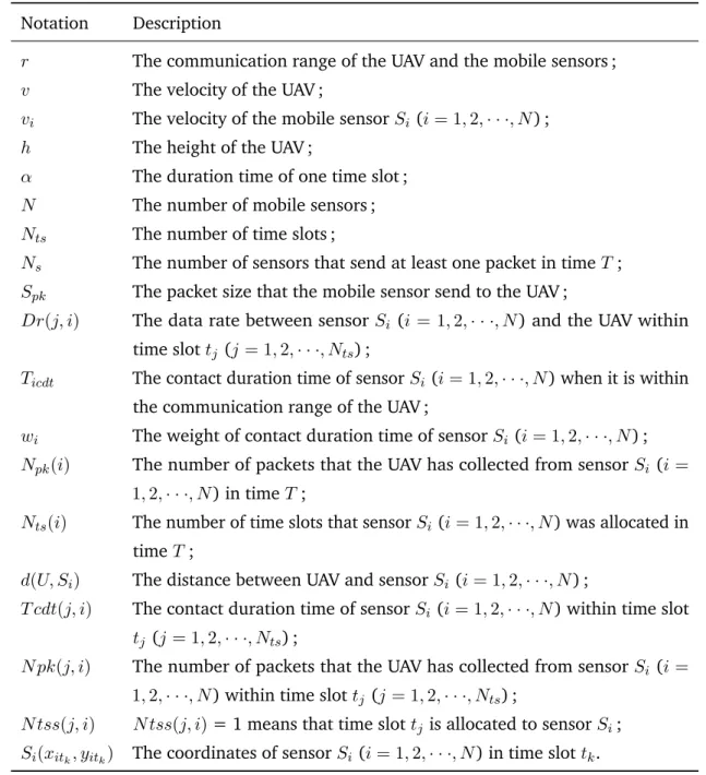
3.3 The impact of UAV velocity on #Packets, W Fpkand W Fts. . . 53
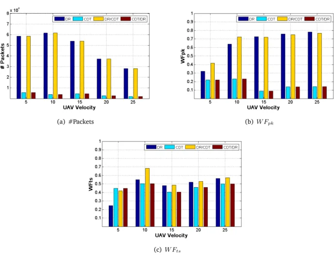
3.4 The impact of UAV height on #Packets, W Fpkand W Fts. . . 55
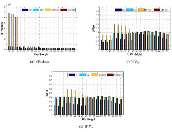
3.5 The impact of sensors mobility on #Packets, W Fpk and W Fts. . . 56
3.6 The impact of sensors density on #Packets, W Fpk and W Fts. . . 57
4.1 Scenario in multi-hop case. . . 65
4.2 An illustration of multi-hop data collection covered by UAV in time-slot tk. . . 66
4.3 A simple example to present the contact duration time. . . 69
4.4 Comparison of HVOR, ANOR and DC, with PGT. . . . 73
4.5 Comparison of HVOR, ANOR and DC, with RGT. . . . 74
4.6 The impact of traffic load on the HVOR, ANOR and DC protocols. . . . 76
4.7 The impact of network size on the delivery ratio, energy consumption and fairness. . . 86
4.8 The impact of time-slot length on the delivery ratio, energy consumption and fairness. . . . 88
4.9 The comparisons of the proposed protocol and the existed protocols. . . 90
5.1 Superframe architecture. . . 96
5.2 The upper bound of inter-beacon duration. . . 98
5.5 The simulated protocols in this work. . . 106
5.6 Evaluation of the proposed protocols. . . 107
5.7 Comparison with existing protocols. . . 108
5.8 The impact of inter-beacon duration. . . 110
List of tables
2.1 Summary of Sensors Categories . . . 9
2.2 Altitude and Weight Classification of Current UAVs . . . 12
2.3 Classification of the Current UAVs according to Range and Endurance . . . 13
2.4 Comparison of existing MAC protocols . . . 32
3.1 Multi-data-rate values . . . 43
3.2 Summary of notations used in this chapter . . . 45
3.3 Simulation parameters . . . 52
4.1 Notations applied in this chapter . . . 67
4.2 Simulation Parameters used in the evaluation of HVOR protocol . . . . 72
4.3 Notations applied in TOCC algorithm . . . . 81
4.4 Simulation parameters used in TOCC algorithm . . . . 85
5.1 The relationship between CBP, CFP and IBD in this work . . . 102
5.2 Simulation parameters . . . 106
CHAPITRE
1
Introduction
Contents
1.1 Context . . . . 2
1.2 Motivation and Assumptions . . . . 3
1.3 Contributions . . . . 4
1.4 Structure of the Thesis . . . . 5
1.1
Context
Unmanned aerial vehicles (UAVs) such as balloons and quadcopters are enabled by the advances in com-puting, communication, and sensing as well as miniaturization of devices. They are receiving significant attention in the research community [42]. Due to their ease of deployment, low maintenance cost and high maneuverability, UAVs become an integral component in critical applications such as border surveil-lance, disaster monitoring, traffic monitoring, and remote sensing. Such vehicles have also been used in military [7,74], agriculture [1], and industrial [112] applications. Single or multiple UAVs usually used as communication relays or aerial base stations for network provisioning [50].
More recently, new possibilities for commercial applications and public service for UAVs have begun to emerge, with the potential to change significantly our daily lives such as air delivery service. 2014 has been a pivotal year that has witnessed an unprecedented proliferation of personal drones.
UAVs have also been proposed for delivering broadband data rates in emergency situations through low-altitude platforms. Indeed, several projects in Europe have been investigating the use of aerial base stations to establish opportunistic links and ad-hoc radio coverage during unexpected and temporary events. Moreover, incorporating UAVs into ground networks has attracted more attention from the research community nowadays. For instance, in [105] the authors proposed a cooperative networking framework for multi-UAV guided ground ad hoc networks. A cooperative aerial-ground robotic system is developed for a ground vehicle navigation system through visual feedback from a quadcopter in [79].
The UAV-assisted networks, classified as fly ad hoc networks (FANET) [10], is a special form of mobile ad hoc networks (MANET) and vehicular ad hoc networks (VANET). FANETs have different characteristics from other forms of ad hoc networks, such as, the node mobility, frequency change of node density and network topology, etc. Mobility is a major concern in a UAV-assisted network. Such different characteristics call for the need to design and test new communication protocols in a layered approach suitable for FANETs. Employing UAVs to provide connectivity for ground sensor networks has been studied in [25]. In this thesis, an aerial-ground cooperative sensor networking architecture is proposed. An unmanned aerial vehicle aids the ground sensor subnetwork for data collection through air-to-ground and ground-to-air communications.
1.2 - Motivation and Assumptions 3
1.2
Motivation and Assumptions
Data collection is an important task in wireless sensor networks and this task has been guided for several years by the most investigated theme among researchers which is energy efficiency. Indeed, data collection was studied first in WSNs with one single Sink then with multiple Sinks to balance the energy consumption among the relay sensor nodes. Moreover, other data collection schemes have been proposed based on the use of mobile sinks. It has been argued in the literature that a mobile sink may improve the energy dissipation compared to a static one. Indeed, The drawbacks of using a static sink are well know. For instance, the nodes that are in the sink vicinity deplete their energy much earlier compared to the nodes located farther away from the sink due to higher data relaying load.
Mobility in WSNs has been extensively studied [38,57]. Most mobile WSNs use custom protocols, developed for each specific application, e.g. crop monitoring [115], pipelines safety detecting [6], etc. However, in highly dynamic networks, it is principal for most of nodes to build connection with the destination because of the limited contact duration time between the source nodes and the destination. We need standard mechanisms that is specific for such highly dynamic networks.
In this thesis, we argue for the use of the UAV as a flying Sink. Although it is clear that such sink improves load balancing among the nodes, it is an open question whether this also leads to improvements in fairness and number of collected packets. Thus, we aim to study those performance metrics in UAV-assisted WSNs. And we concentrate on the MAC and network layers since they are fundamental and crucial blocks for all networks.
Obviously, using a flying sink to collect data from a mobile on-ground sensor network is a challenging task because of the link intermittence and the dynamicity of the network.
Considering all the movement paths can be refined into multiple straight path, we decide to focus on the linear motion mobile networks.
1.3
Contributions
The primary goal of this thesis is to tackle the data collection problem in UAV-aided mobile wireless sensor networks and to propose efficient solutions for data collection in such systems. All the algorithms that we come-up with and the metrics defined in the following chapters follow this goal.
The performance of the data collection relies on different levels. The medium should be shared carefully, giving the limited opportunities for communication between the mobile sensors and the flying UAV, as well as the high variation of the physical parameters (such as data rate which depend on the relative position of communicating nodes). This issue suggests to adapt the medium access layer and to manage the communications according to an efficient transmission scheduling.
The network is delay tolerant, and we focus on noncritical applications, useful for covering sportive events or organizing rescue operations.
Moreover, as a consequence of the mobility of nodes, the network topology is highly dynamic, and the opportunities given to each node to be in a direct contact with the data collector rely heavily on the nodes positions which require opportunistic communications and adapted routing.
Indeed, this thesis proposes innovative data collection scheduling schemes, it also modifies the MAC and routing levels, to meet the requirements of the studied system.
Firstly, we propose four new contention free algorithms for data collection in UAV-assisted mobile WSN.
The main performance metric in data collection issues is the packet delivery ratio. And the main factors that affect the performance are the data-rate and contact duration time between the source nodes and the destinations. Based on the two metrics, we proposed four data collection algorithms in Chapter3. To ensure the contention free, we divide the time into short unit time slots, and only one node has an opportunity to send data in the time slot.
Secondly, we highlight the impact factors of data-rate and contact duration time and study the in-depth factors : the sensors velocities. Combining these factors, we propose a highest velocity opportunistic routing algorithm.
1.4 - Structure of the Thesis 5
source nodes and destination move. Thus, the nodes speed has a huge impact on the performance metrics. Then, we propose a highest velocity opportunistic routing (HVOR) algorithm. In HVOR, the source nodes only build connections with the one that has the highest velocity among its neighbors. Similar to traditional opportunistic routing algorithms, the selected nodes in HVOR cannot guarantee the communication between the relay nodes and the destinations.
Thirdly, we propose an opportunistic routing protocol which provides a guaranteed communication between the forwarders and the destination.
Combing all the aforementioned impact factors, we define the competition compacity for each relay node. We propose a forwarder selection algorithm and make a scheduling between the forwarders and the UAV. The scheduling guarantees that each forwarder has an opportunity to communicate with the UAV. Finally, the transmission with an opportunistic competition capacity (TOCC) algorithm is proposed for the communication between forwarders and the simple nodes.
Finally, we introduced two adaptive hybrid MAC protocols based on beacons that improve the packet delivery ratio and the fairness.
In beacon based IEEE 802.15.4 protocol, the scheduling information in the beacon is used for next inter-beacon duration.
This metric has a limitation in our studied scenarios. That is because the contact duration time between the source node and the destination is limited in highly dynamic networks. Based on the dynamic characters, we define an upper bound for the inter-beacon duration. During each inter-beacon duration, we define the contention-based duration and contention-free duration adaptively according to the real-time topology information of the network. In the proposed adaptive hybrid MAC protocols, we fully take into account the real-time dynamic topology of the network.
1.4
Structure of the Thesis
This thesis is organized in six chapters. The first chapter presents a context to the wireless sensor networks, the motivation and contributions of this thesis. The second chapter concentrates on the state of art on
unmanned aerial vehicles assisted WSN. The categories of sensor, UAV and their applications are presented in this chapter. It also introduces the functionalities of the UAV as a communication node, as well as the trajectory planning and placement. Furthermore, the second chapter gives the readers the context on data collection, routing and medium access control for understanding the rest of this thesis.
From Chapter3, each of chapter presents at least one contribution of this thesis. In Chapter3, we start with four contention free data collection algorithms in one-hop communications. And we continue on studying the opportunistic routing in multi-hop communications in Chapter4.
In Chapter5, we present two novel adaptive hybrid MAC protocols. The two MAC protocols enhance the packet delivery ratio and the fairness of the network. Chapter6concludes this thesis and opens up some perspectives.
CHAPITRE
2
State of Art
Contents
2.1 Introduction . . . . 8
2.2 Wireless Sensor Networks . . . . 8
2.2.1 Categories of sensors . . . 9
2.2.2 Heterogeneous WSN . . . 10 2.3 Unmanned Aerial Vehicles . . . . 11
2.3.1 Categorizes of the UAV . . . 11
2.3.2 Fling Ad-Hoc Network (FANET) . . . 12
2.3.3 Applications of UAV-based WSN . . . 14 2.4 Unmanned Aerial Vehicles as a Communication Node . . . . 15
2.4.1 Functionalities . . . 16
2.4.2 Trajectory planning and placement . . . 18 2.5 Data Collection Applications . . . . 20
2.5.1 Performance Parameters . . . 21
2.5.2 Classification of the Data Collection Underlying Protocols . . . 22 2.6 Underlying Layers for UAV assisted Networks . . . . 23
2.6.1 Routing Protocols . . . 23
2.6.2 Medium Access Control Protocols . . . 31
2.1
Introduction
The story of sensor networks can be tracked back to the 1960s, when the United States Navy had deployed a Sound Surveillance System (SOSUS) using hydrophones (microphones deployed underwater) on the bottom of the ocean to detect submarines. They applied 40 hydrophones to trail, then, they extended the project to the entire East and West Coasts [120]. At that time, the transmissions were done through multi-conductor armored cables. Nowadays, wireless sensor nodes are used to detect the earthquakes in the Pacific [62]. Indeed, a new class of networks has appeared in the last decade : the so-called Wireless Sensor Network (WSN). They consist of individual nodes that are able to interact with their environment by sensing or controlling physical parameters ; these nodes have to collaborate to fulfill their tasks as, usually, a single node is incapable of doing so ; and they use wireless communication to enable this collaboration [63]. Wireless Sensor Networks are widely used in several applications such as military, environmental, health-care, and home applications.
2.2
Wireless Sensor Networks
A Wireless Sensor Network (WSN) is a network composed of a large number of low-power devices that sense the environment and send their readings to one or more Sinks [8]. The devices composing a WSN are called sensor nodes, or motes, and they have the following characteristics
– they are small ;
– they have limited memory, processing power, and energy (most of them are battery powered) ; – they are composed of sensing, data processing, and communication components.
– they have limited communication range and data-rate.
2.2 - Wireless Sensor Networks 9
2.2.1 Categories of sensors
Handling a wide range of application types will hardly be possible with any single type of a sensor node. Nonetheless, certain common traits appear, especially with respect to the characteristics and the required mechanisms of such networks. Indeed, in the majority of applications, the sensors require readiness for field deployment in terms of economic and engineering efficiency. The scalability of the sensor is also important in distributed environmental monitoring tasks, which require that the sensors be small and inexpensive enough to scale up to many distributed systems. Sensors are deployed in hundreds of thousands. Therefore, it is expected that the cost will drop but current generation sensors are still expensive to allow widely deployment [94].
Sensors can be classified in terms of where they are deployed or used (Table2.1[94]) :
Table 2.1.Summary of Sensors Categories
Sensor Category Parameter Field-Readiness Scalability
Physical
Temperature High High Humidity (soil, leaf, ambient) High High Wind (speed and direction) High High Pressure High High
Chemical
Dissolved Oxygen High High pH High High Heavy metals Low Low Nutrients (Nitrate, Ammonium) Low-Medium Low-High Biological Microorganisms Low Low
Biologically active contaminants Low Low
For instance, for water quality monitoring, physical sensors are generally more field-ready and scalable than chemical sensors, that are in turn, substantially more field-ready and scalable than biological sensors.
2.2.2 Heterogeneous WSN
Sensor nodes can be heterogeneous by constructions, that is, some nodes have larger batteries, farther-reaching communication devices, or more processing power. They can also be heterogeneous by evolution, that is, all nodes started from an equal state, but because some nodes had to perform more tasks during the operation of the network, they have depleted their energy resources or other nodes had better opportunities to scavenge energy from the environment (e.g. nodes in shade are at a disadvantage when solar cells are used).
Whether by construction or by evolution, heterogeneity in the network is both a burden and an opportunity. Heterogeneous WSN consists of sensor nodes with different abilities, such as various sensor types and communication range, thus provides more flexibility in deployment. For example, we can construct a WSN in which nodes are equipped with different kinds of sensors to provide various sensing services [63]. In the thesis, we consider that the studied systems are heterogeneous as the sensors are either on-ground mobile (fixed on bicycles) or flying (UAV). Moreover, we also considered that the sensors may have different speeds.
Several issues are still to be solved in heterogeneous wireless networks such as determining the theoretical capacity of heterogeneous WSN, interpretability of different technologies, mobility, Quality of Service, and so on. There are several benefits to a heterogeneous WSN as opposed to a traditional homogeneous wireless network including increased reliability, improved spectrum efficiency, and increased coverage. Reliability is improved because when one particular access technology within the heterogeneous WSN fails, it may still be possible to maintain a connection by falling back to another access technology. Spectrum efficiency is improved by making use of access technologies which may have few users through the use of load balancing across access technologies and coverage may be improved because different access technologies may fill holes in coverage that any one of the single networks alone would not be able to fill.
2.3 - Unmanned Aerial Vehicles 11
2.3
Unmanned Aerial Vehicles
Unmanned aerial vehicles (UAVs) have gained much popularity in a variety of applications which do not need human interaction or are dangerous (e.g. In Hurricane Katrina, two UAVs were used to search and rescue for the trapped survivors [5].) for human operators. UAVs have been widely applied for human life, from early military, environmental and urban applications to modern-day Facebook, Google and Amazon applications. Facebook has successfully tested its internet-beaming drones [3] and Amazon provides a special product delivery within 30 minutes in 2016 [2].
Enabled by the advances in computing, communication, and sensing as well as the miniaturization of devices, UAVs such as balloons, quadcopters, and gliders, have been receiving significant attention in the research community. They become an integral component in several critical applications such as border surveillance, military operations [7,74], disaster monitoring, traffic monitoring, remote sensing, and the transportation of goods, medicine, and first-aid. More recently, new commercial applications are emerging, with the potential to dramatically change the way in which we lead our daily lives.
Among the many technical challenges accompanying the aforementioned applications, leveraging the use of UAVs for delivering broadband connectivity plays a central role in next generation communication systems [42]. Facebook and Google announced in 2014 that they will use a network of drones which circle in the stratosphere over specific population centers to deliver broadband connectivity. UAVs have also been proposed as an effective solution for delivering broadband data rates in emergency situations through low-altitude platforms. They can serve as a temporary, dynamic, and agile infrastructure for enabling broadband communications, and quickly localizing victims in case of disaster scenarios.
2.3.1 Categorizes of the UAV
An unmanned aerial vehicles (UAV), commonly known as a drone is an aircraft with no human on board. UAVs can be remotely controlled aircraft (e.g. flown by a human at a ground control station) or can fly autonomously based on pre-programmed flight plans or more complex dynamic automation systems. UAVs can be drones, quadcopters, gliders and balloons etc, and also can be their improved models carrying
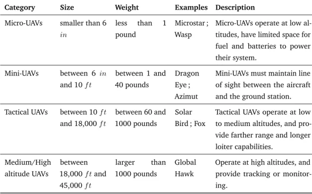
Table 2.2.Altitude and Weight Classification of Current UAVs
Category Size Weight Examples Description
Micro-UAVs smaller than 6 in
less than 1 pound
Microstar ; Wasp
Micro-UAVs operate at low al-titudes, have limited space for fuel and batteries to power their system. Mini-UAVs between 6 in and 10 f t between 1 and 40 pounds Dragon Eye ; Azimut
Mini-UAVs must maintain line of sight between the aircraft and the ground station. Tactical UAVs between 10 f t
and 18,000 f t
between 60 and 1000 pounds
Solar Bird ; Fox
Tactical UAVs operate at low to medium altitudes, and pro-vide farther range and longer loiter capabilities. Medium/High altitude UAVs between 18,000 f t and 45,000 f t larger than 1000 pounds Global Hawk
Operate at high altitudes, and provide tracking or monitor-ing.
payloads (e.g. microdrones, carrying cameras)
There is more than one category when it comes to the classification of UAV. Generally, UAVs are classified by size, range and endurance, etc. Endurance is the amount of flying time of the UAV, and the range is the working radius of the UAV. For classification according to size, one can come up with the following sub-classes (Table2.2[22,23]). If we take into account the range and the endurance, the UAVs are classified as in Table2.3[22,23].
2.3.2 Fling Ad-Hoc Network (FANET)
Ad hoc networks are wireless networks capable of organizing without previously defined infrastructure. Each node communicates directly with its neighbors. To communicate with other nodes, it is necessary to pass on its data to others which will be responsible for forwarding it. To do this, it is first and foremost important that the nodes are situated in relation to each other, and are able to construct routes between them : this
2.3 - Unmanned Aerial Vehicles 13
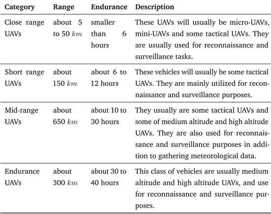
Table 2.3.Classification of the Current UAVs according to Range and Endurance
Category Range Endurance Description
Close range UAVs about 5 to 50 km smaller than 6 hours
These UAVs will usually be micro-UAVs, mini-UAVs and some tactical UAVs. They are usually used for reconnaissance and surveillance tasks. Short range UAVs about 150 km about 6 to 12 hours
These vehicles will usually be some tactical UAVs. They are mainly utilized for recon-naissance and surveillance purposes. Mid-range UAVs about 650 km about 10 to 30 hours
They usually are some tactical UAVs and some of medium altitude and high altitude UAVs. They are also used for reconnais-sance and surveillance purposes in addi-tion to gathering meteorological data. Endurance UAVs about 300 km about 30 to 40 hours
This class of vehicles are usually medium altitude and high altitude UAVs, and use for reconnaissance and surveillance pur-poses.
is the role of the routing protocol. Thus, the operation of an ad-hoc network significantly differentiates it from a network such as the Cellular network or Wi-Fi networks with access points : where one or more base stations are required for most communications between the different nodes of the network (Infrastructure mode), the ad-hoc networks organize themselves and each node can play different roles.
Similarly, a Fling Ad-Hoc Network (FANET) is simply an Ad-hoc network between several UAVs. It is part of the Vehicular Ad-hoc Networks (VANETs) themselves forming part of Mobile Ad-hoc Networks (MANETs) (The relationship is presented in figure2.1). A FANET is a multi-UAV communication network where the mobility degree of nodes is much higher than the mobility degree of MANET (Mobile Ad-hoc Network) or VANET (Vehicular Ad-Hoc Network) nodes. While typical MANET and VANET nodes are walking men and cars respectively, FANET nodes fly in the sky [10].
Figure 2.1.The relationship between FANET, VANET and MANET [10].
2.3.3 Applications of UAV-based WSN
Using UAVs extends significantly the deployment possibilities and its envisioned applications will be much more diverse in our daily life. Applications for UAV-assisted WSNs may either be traditional ones as home automation ; environmental and habitat monitoring ; industrial monitoring and control ; military ; security ; and health-care or completely new types of applications. Indeed, UAVs will allow rapid and easy deployments especially to rough and dangerous environments. They can offer to the sensor network quick access to more important technology in terms of end-to-end delay and throughput allowing the transport of different types of data, including global positioning systems (GPS) location, streaming video/voice, images, etc. This is much more important in new emergent applications such as rescue operations, traffic monitoring in smart-cities, and disaster management.
Hereafter we summarize some already deployed applications, we group them as follows,
– Military applications, including military combat [7], battlefield operation and military communication [74].
– Environmental applications, Homeland Surveillance & Electronics (HSE) offers 11 models of agriculture UAV crop dusters sprayers, 6 helicopters and 5 multi-rotor UAV crop dusters, to monitoring moisture, parasite and crop growth, etc [1].
– Urban applications, like traffic monitoring, urban surveillance and civilian security [80].
– Industrial applications, including product quality monitoring and Smart-Grid measurements [112]. Furthermore, the applications can be also classified with respect to the area where the sensors are deployed. In the first class, the nodes are scattered either on ground for crop monitoring [115] or underground such as
2.4 - Unmanned Aerial Vehicles as a Communication Node 15
for pipelines safety and monitoring [6]. This category is the most widely used and usually can not be used under water. The second class corresponds to underwater deployments wherein the sensors use acoustic communications [84]. This class of application usually cost a lot due to the protection of sensors from water when they were deployed for a long time under water. The third class is the hybrid one ; it combines both of the previous deployment modes, which not only widen the scope of application but also decreases the cost. In [52] for instance, sensor nodes are floating within a restricted area on the sea surface for the monitoring of marine disasters.
Regardless of the application domain, either the UAVs or the WSN have different application functionalities. The UAV is mainly involved in packet relying, data collection, WSN connectivity maintaining and Localization. Elsewhere, the WSN is in charge of data gathering, monitoring, object tracking, event detection and processing.
Thereafter, data collection and retrieval mode is a key characteristic in those applications and has an important impact on the whole system performance. Moreover, it decides on the UAV flight path (planned or unplanned trajectory, stationary or moving). Data collection and retrieval modes can be categorized into [9] : i) query driven, where the nodes send data only when required. ii) event driven, the nodes transmit data to the UAV only when an event occurs. iii) time driven, the sensor nodes communicate their readings to the UAV periodically. Time driven application is the most common one and has been broadly used in military and environmental applications.
2.4
Unmanned Aerial Vehicles as a Communication Node
One of the primary goals of the WSN applications is to process meaningful information from data obtained by sensor nodes deployed on the field. Thus, the sensed data must be transferred to a sink for processing and obtaining meaningful inferences. Traditionally, the data collection was processed in multiple hops. The nodes that are closer to the collector end up being relay nodes for the data of other nodes which are further away from the collector. As a result, these nodes lose energy much faster as compared to those who do not have to act as relay nodes frequently. Consequently more rapid death of these nodes results in getting the
network disconnected, which in turn leads to a loss of coverage. To address this issue mobile nodes were introduced.
The traditional mobile nodes usually move on the ground with limited speeds and movement conditions. It is challenging to apply the traditional mobile nodes in harsh areas (such as snow mountain, wild forest, etc.). UAV become a better choice for such applications because of its extensive and flexible conditions. As a communication node in WSN, the main functionalities of the UAV, including data collection, maintaining connectivity and localization, will be detailed in the following.
2.4.1 Functionalities – Data collection
The traditional data collection protocols were based on the assumption of dense networks so that any two nodes could communicate with each other through multi-hop paths. Hence, sensors were usually assumed to be static, and mobility was not considered. After the introduction of mobile nodes, it is a challenging task in WSN to collect the data from the mobile nodes and send it to the base station for processing.
Numerous applications are constrained by the difficulty of data collection, especially when working in harsh terrains (e.g. snow mountains, highly dense forest, vast and hot desert, etc.). Thus, many kinds of research have been done in both energy scheme (e.g. energy conservation [60,61], incremental deployment [88] and environmental energy harvesting [86]), collecting data scheme [85] and optimal speed control of UAV scheme [111] to collect data efficiently. Pang et al. [85] formulate the data collection in rechargeable WSNs into an optimization problem with the objective of maximizing data collection utility. They also give a novel side matching algorithm and a novel greedy algorithm to solve the distributed issues. In 2007, Kurs et al. [71] have a major breakthrough on wireless power transfer to provide a promising alternative for energy replenishment of sensors.
– Connectivity Maintaining/Relaying
Connectivity is a central problem in WSNs because the failures occurrence will lead to partially disconnecting of networks. One of the most powerful methods used for such network problems is to provide a reliable
2.4 - Unmanned Aerial Vehicles as a Communication Node 17
connection to support the connectivity via other kinds of nodes (e.g. mobile sink) that communicate with the sensor nodes. Extensive research has been conducted on maintaining UAV-assisted networks connectivity. Fodor et al. [37] focus on optimizing the routing in WSN with mobile sinks. However, this method does not maintain connectivity all the time. Thus, other approaches assume that the UAVs movement is predictable that can improve the WSN connectivity [57]. Kuiper and Nadjm-Tehrani [70] present a method combining position scheme and beacon-less strategy to maintain intermittent connection in ad hoc networks. Similarly, Edison et al. [25] apply a beacon-based mechanism to support WSN connectivity. Kuiper’s method handles the disconnection problems in his paper while Edison avoids the issues through the UAVs movement. – Localization
Location-based service plays a more and more important role in humans’ daily life. Location information is of great value to understand events detected in the sensing field. Localization of sensors is essential for the normal operation of WSN. Location-awareness of sensors is a fundamental and crucial problem in a wireless sensor network.
To guarantee the sensed coverage and good localization accuracy, WSN is usually composed of a large number of sensor nodes with high dense deployment in a field. Typically, sensors are deployed without their position information known in advance. A simple way to get the location information is to place them at certain positions manually. However, when the number of sensors is large, this becomes tedious. GPS [28] is another popular way which can offer good localization accuracy. However, it is not possible to equip every sensor node with a GPS module when taking into account the factors of power consumption, volume and cost. Localization mechanisms with mobile vehicles then have been proposed to overcome the shortage of the above methods. With the beacons provided by vehicles, sensors can realize self localization with few methods. The vehicles localization based schemes are categorized into static vehicle localization and mobile vehicle localization. In static case [34], the localization accuracy highly depends on the number and the position of the vehicles. The feature of uniform distribution and dense deployment of vehicles will lead to a better localization accuracy, but also with added cost. To overcome the problem, schemes with mobile vehicles are proposed. A mobile vehicle can obtain its own location information with the use of GPS or other localization technologies, and it travels around the sensing field while broadcasting its current coordinates
in the form of a beacon message. A sensor that has received the beacon could conduct that it is within the communication range of the mobile vehicle. When enough beacons are received, the sensor can estimates its location with a few methods that have been proposed.
In the context of UAV-assisted WSNs, authors in [117], the authors address the problem of 3D localization in WSNs using an UAV. The UAV is equipped with GPS and it flies over the monitoring area broadcasting its geographical position. Thus, the sensor nodes are able to estimate their geographical position without being equipped with GPS receiver. GPS is an efficient technique in the estimation of position in outdoor applications. It is better for the GPS to be used far enough from buildings or obstacles otherwise GPS signals become unreliable. In UAV-aided WSNs, the UAVs require an additional estimation, to remain operating after GPS failure. In [99], the authors proposed a real-time localization algorithms to estimate the position and velocity of an UAV using an Extended Kalman Filter [125] based on time difference of arrivals. Their algorithm makes a good estimation of position and velocity. Halder et al. [43] give a review on mobility-assisted localization techniques in WSNs.
2.4.2 Trajectory planning and placement
As mentioned in Chapter2.4.1, localization is a fundamental and crucial problem in WSN. A few methods [48,114] have been proposed to deal with this issue, while schemes with mobile vehicles stand out, due to the characteristics of mobility and flexibility. One key issue of the vehicles based scheme is path planning. Proper path planning can guarantee good coverage of the whole sensing field while keeping the path length reduced at the same time. In recent years, a wide range of researches has been done on this topic, with many algorithms proposed. The objective functions and optimization methods are different according to different applications.
The objectives of path planning in a mobility based sensor network are listed as follows :
– Reliable coverage of the whole sensing field. We have to make sure that the path of the vehicle will cover all the sensors that need to be localized. Shazly et al. [106] formulate an area coverage reliability problem that quantifies the likelihood that the network can be in an operating state where the coverage condition is satisfied.
2.4 - Unmanned Aerial Vehicles as a Communication Node 19
– Path length reduction. The whole path length should be controlled to reduce energy consumption and the localization delay. Kashuba et al. [64] proposed an effective path length reduction algorithm for UAV path planning in a sensor network where flying platform is used for data gathering. Their proposed algorithm has low computational complexity and it can be implemented not only on control center equipment but on UAV controller.
– Fine localization accuracy. Path planning makes it possible to choose the optimal position to send beacon messages to improve accuracy. Authors in [121] studied on UAV path planing accuracy problem and presented an novel algorithm which takes into account both the efficiency of flying and accuracy of positioning.
– Minimization of energy consumption and maximization of the quality of data communication. In [29], the authors proposed an energy efficient mechanism based on genetic algorithm for autonomous mobile robots. The constraints of natural terrains : obstacles and relief are considered. In [107], Sahoo et al. proposed Infrastructure based Data Gathering Protocol (IDGP) and Distributed Data Gathering Protocol (DDGP) to plan the data gathering path for a mobile sink.
The simplest way for the vehicle to move around the whole field is random walking. The author in [59] proposed a random mobility model based on random directions and speeds, whose current speed and direction are independent of its past ones. However, too frequent change randomly may lead to effortless moving, so trajectory planning/placement of mobile vehicles was introduced.
Path planning makes sure that the vehicles will move with definite purpose. Generally, according to whether there is interaction between vehicles and sensors, path planning of vehicles can be classified into two categories,
– Static path planning, which determines the trajectory for mobile vehicles in advance and then vehicles move along the pre-determined trajectory strictly. Research in [44] proposed a path planning scheme based on trilateral to achieve maximum performance with minimum movement ; the vehicle moves according to an equilateral triangle trajectory to send beacon messages. With the distance measured by received signal strength, then a sensor, with three beacons received, can calculate its location. The feature of triangle trajectory can provide three different beacons, which can efficiently solve the collinearity
problem.
– Dynamic path planning, in which no trajectory is set in advance and the vehicles determine their next walking direction with specific strategies, according to the information obtained by interaction with sensors that have not been localized during the localization procedure. Dac-Tu Ho et al. applied UAVs as mobile vehicles [48], they focus on minimizing the total flight time of the UAV and energy consumption of the nodes and maximizing the quality of data communication via the wireless channel between any node and its cluster head, and between the cluster heads and the UAV. They aim to provide a list of nodes which are then to be visited by the UAV and provide a path for the UAV to follow to complete one round of data collection.
2.5
Data Collection Applications
As aforementioned, WSNs are widely used in several applications ranging from military, agriculture to health monitoring. Data Collection is one of the most important issues in WSN, and this problem has witnessed a significant amount of researches over the decades. Traditionally data gathering schemes based on the static topology where the nodes are statically deployed but later on mobile nodes which are more energy efficient. The main idea of data-gathering is to sense data and forward these data to the collectors for further processing. Traditionally, the data transmissions were done in multiple hops. The relay nodes help the simple nodes to forward their data. Thus, they die out (lose energy) fastly which eventually lead to loss of coverage. Then, mobile nodes in such context were introduced. Mobile nodes move around the network in a pre-defined or random path to collect and forward the data. Data collection using mobile nodes consists of three phases [26] :
i) Discovery : In this phase, the mobile collectors broadcasts "hand-shake" messages to its coverage to inform
the nodes within its range the collector is coming. The sensors that received the message can identify the presence of the mobile collector. ii) Data Transfer : The nodes start to send data after they identify the presence of the collector. The goal of the data transfer phase is to achieve maximum data throughput during the limited contact duration time between the collector and the simple nodes. More generally, both the
2.5 - Data Collection Applications 21
nodes and the collectors are mobile, the data gathering in such dynamic context involves many important parameters among which the contact duration time and the data-rate between the collectors and the simple nodes present tremendous impact on data collection. iii) Routing : The mobile collectors forward the collected data to the sink or the base-station in this phase.
2.5.1 Performance Parameters – Contact Duration Time
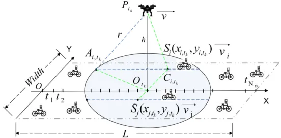
Figure 2.2.Simple Scenario with 1 UAV and 1 Sensor
Considering that the "one UAV and one sensor" was the basic unit in UAV-assisted WSNs, we take the scenario like in figure 2.2for example to calculate the communication time. The common scenarios will be taken into account in the following chapters.
In figure 2.2, UAV moves along a path to provide continuous connectivity and help in balancing the load on nodes. The sensor has an opportunity to communicate with the UAV when the UAV within its communication range. It is crucial to know the link intermittency in such context.
According to [58], the contact duration time between the UAV and the sensor (Tcdt) can be written as in
Tcdt=
2√r2− h2
v , (2.1)
where, r is the communication range of the UAV and the sensor. Indeed, we assume that the UAV and the Sensors have the same communication range for definiteness and without loss of generality. v and h are the
velocity and the flying height of the UAV respectively. As shown in figure 2.2, when the UAV flies on the top of a sensor, Tcdtcan achieve its maximum value. This is present in equation (2.1). The longer the contact
duration time between the UAV and the sensor, the more messages were gathered between them. – Multi-rate Mechanism
The communication performance is affected by the path loss, interference, and shadowing, etc. The data-rate between the UAV and nodes depends on the relative distance between them and the relative distance is changing over time. Thereby the data-rate is varying with the movement of the network also. Thus, it is more reasonable to use a multiple data-rate mechanism among different nodes during different times. A 4-pairwise communication parameters setting [77] is adopted in many applications. The higher the data-rate between the UAV and the node, the more data were transmitted between them.
According to the deployed environment where the application is used, the data collection schemes can be roughly divided into i) Data Collection Schemes based on the Static Topology. In this category, both the sensor nodes and the collector are statically deployed. ii) Data Collection Schemes based on the Mobile Topology. In mobile topology, the design of nodes and collectors depends on the applications ; some applications only need moving nodes or only need moving collectors while other applications should consider both of them moving. For instance, in rescue field or animal tracking, both the collector and the interest objects are moving.
If we take into account the hops of the schemes that the applications need, the data collection schemes can be classified as One-hop communication protocols and Multi-hop communication protocols.
2.5.2 Classification of the Data Collection Underlying Protocols – One-hop communication protocols
In this case, source nodes that are within the range of the destination node can directly communicate with the collectors. The transmission in this context requires appropriate distance between the source nodes and the destination nodes, and there are no obstacles between them and obstruct them to communicate with each other. If there are multiple nodes within the range of the destination node at the same time, the medium can be shared according to different protocols that can be further classified as Contention-based
2.6 - Underlying Layers for UAV assisted Networks 23
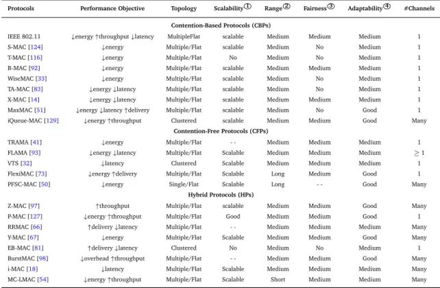
protocols, Contention-free protocols and Hybrid protocols. Many protocols have been proposed on these three classifications, such as B-MAC [91] (Contention-based), FLAMA [93] (Contention-free), Z-MAC [97] (Hybrid) and so on, Which will be detailed in Chapter2.6.2on medium access control protocols.
– Multi-hop communication protocols
It is better for the source nodes that are out of the range of the destination node or have poor transmission conditions (e.g. high energy consumption, high packet losses, etc.) to send packets by means of intermediate nodes that are within the range of the destination node and the source node at the same time or have better communication situations. The group of intermediate nodes is usually called Potential Forwarders. The use of mechanisms mainly depends on the network information provided by each node. In this sense, the multi-hop protocols can be further categorized and detailed in Chapter2.6.1on routing protocols.
2.6
Underlying Layers for UAV assisted Networks
2.6.1 Routing ProtocolsRouting protocols in sensor networks is very challenging due to several characteristics : i) generally, sensor nodes are battery powered, they are tightly constrained regarding transmission power, on board energy, processing capacity and storage and thus require careful resource management. ii) in large scale sensor networks, it is difficult to design a global addressing scheme for the sensor deployment. iii) in most WSN applications, the sensed data are usually required to be transmitted from multiple source nodes to a single destination node. iv) the data generation traffics have some redundancy in many applications since multiple sensors may generate the same data. Such redundancy needs to be exploited by the routing protocols to improve the network performance.
General Classifications of Routing Protocols
Several protocols are used in FANET. Some are more effective where others are simpler to implement. Most of routing protocols can be classified as data-centric, hierarchical, location-based or QoS-aware. Data-centric protocols are query-based and depend on the naming of desired data. Hierarchical protocols
aim at clustering the nodes so that cluster heads can do some aggregation and reduction of data to save energy. Location-based protocols utilize the position information to relay the data to the desired regions. The QoS-aware are based on general network flow modeling for meeting some QoS requirements.
– Data-centric protocols
Since transmitting data from each sensor node within the deployment region might result in significant unnecessary redundancy in data and incur in unnecessary energy and traffic expenditure, routing protocols that can select a set of sensor nodes and utilize data aggregation during the relaying of data have been considered.
In data-centric routing, the sink sends queries to selected regions which might be selected using clusters and waits for data from the nodes located in the regions. Since data is being requested through queries, attribute-based naming is necessary to specify the properties of data. Sensor Protocols for Information via Negotiation (SPIN) [47] is the first data-centric protocol, which considers data negotiation between nodes to eliminate redundant data and save energy. Later, Directed Diffusion [55] has been developed and has become a breakthrough in data-centric routing. Many other protocols have also been proposed based on Directed Diffusion, such as Energy-aware routing [101], Rumor routing [13] and Gradient-Based Routing [104].
– Hierarchical Routing protocols
Hierarchical clustering, originally proposed in wired networks, is well-known technique in WSNs. The hierarchical routing protocol is an energy efficient approach through sensor nodes, base station, and cluster heads. The main aim of cluster-based routing is to efficiently maintain the energy consumption of sensor nodes and improve network lifetime. In a hierarchical architecture, higher-energy nodes can be used to process and send the information, while low-energy nodes can be used to sense the target. The introduction of clusters can greatly contribute to overall system scalability, lifetime, and energy efficiency. Cluster-based routing is mainly two-layer routing where one layer is used to select cluster heads and the other for routing. Cluster formation is typically based on the energy reserve of sensors and sensor’s proximity to the cluster head. Low Energy Adaptive Clustering Hierarchy (LEACH) [46] is an initial hierarchical routing approaches which considers homogenous wireless sensor network. The selection of cluster heads in LEACH depends
2.6 - Underlying Layers for UAV assisted Networks 25
on the highest residual energy. LEACH rotates cluster head to evenly distribute the energy load among the sensors in the network and extend the network lifetime.
– Location-based protocols
Most of the routing protocols for sensor networks require location information of sensor nodes. In most cases, location information is needed to calculate the distance between two particular nodes so that energy consumption can be estimated. Relative coordinates of neighboring nodes can be obtained by exchanging such information between neighbors [15]. Alternatively, the location of the nodes may be directly available using GPS if nodes are equipped with a small low-power GPS receiver. Location-Aided Routing (LAR) [69] is a location-based routing protocol with an objective to limit the area to build a new route to a smaller request zone. In LAR, the route requests were sent to the whole network. Senouci et al. [103] optimized LAR, and only the nodes in the request zone have opportunities to forward the requests. Thus, the routing overhead is widely reduced.
– QoS-aware Protocols
The network needs to ensure Quality of Service (QoS) besides ease of implement, energy efficiency and low cost. One of the major design goals of WSNs is reliable data communication under minimum energy depletion to extend the lifetime of the network. Some of the routing challenges and design issues that affect the routing process in WSN are : node deployment, coverage, connectivity, node and link heterogeneity, fault tolerance, scalability, transmission media, data aggregation, and QoS. In QoS-based routing protocols, the network has to balance between energy consumption and data quality. Particularly, the network has to satisfy certain QoS metrics (delay, energy, bandwidth) when delivering data to the base station.
SPEED [45] is a QoS-aware routing protocol which is designed for real-time communication in sensor networks. SPEED handles congestion and provides soft real-time communication by using feedback control and non-deterministic geographic forwarding. A node computes speed to each neighbor and then forwards the packet to a neighbor which is close to the destination and has higher speed than other neighbors. In [27], Marot et al. propose a local load balancing routing protocol which aims to help source nodes to apply neighbor nodes potential capabilities without knowing their information. Their protocol improves the reliability and efficiency of the link quality indicator.
Multi-hop Protocols
Several multi-hop protocols exist in the literatures, they can be categorized as deterministic and random, according to the topologies.
(i) Deterministic Topologies
– Static Routing
This scheme establishes a pre-computed static table that is loaded when initializing the network. Unlike a dynamic routing protocol, static routes are not automatically updated and must be manually reconfigured by a network administrator when the network topology changes. Static routing provides ease of routing table maintenance in small scale networks. The route used to send data is known in advance. Thus, it uses little bandwidth as routers do not exchange routes. However, configuring the route table is time-consuming and error-prone, especially in large scale networks.
Load-carry-and-deliver (LCAD) [17] is a static routing protocol using UAVs to relay messages between two ground nodes. The route is configured on the ground before takeoff. In LCAD, the authors object to maximize throughput by configuring nodes positions. This type routing protocols are used for repetitive tasks, such as periodically surveillance missions. Adaptive Routing using Clustered Hierarchies (ARCH) [11] creates a multi-level hierarchy that adjusts its depth dynamically in response to the network topology. These hierarchical routing protocols, such as ARCH which is based on multilevel clustering, consist of a number of different components, such as clustering, routing and location management. Here, clustering is the process by which nearby nodes form groups, called clusters. In [110], the authors study the theoretical scalability aspects of multi-level hierarchical routing in MANET. In the general scheme they analyze, nodes organized in clusters, which are then grouped in higher level clusters. The number of levels is logarithmic in the network size. [110] is one of the crucial papers with comprehensive theoretical results of multi-level hierarchical routing protocols.
2.6 - Underlying Layers for UAV assisted Networks 27
Unlike static routing, dynamic routing helps the network administrator to manage the time-consuming and exacting process of configuring and maintaining static routes. Dynamic routing is able to find remote networks, maintain the routing information, and select the best path to destinations. Therefore, it is suitable in all topologies when multiple routers are required.
1. Application in Connex Topologies
The typical applications in connex topology are based on mobile ad hoc net works (MANET). They can be divided into proactive, reactive and hybrid routing protocols.
– Proactive Routing Protocols
In WSNs, sensors are used to store routing information for a specific region of the network. However, many of the tables must be updated when the topology is changed. Proactive routing protocols are based on periodic exchange of control messages. The main advantage of proactive routing is that it immediately provides the required routes when needed. Thus, a large number of messages are required to keep the system up to date. However, negative points are also present such as the bandwidth constraints on each communication link or the addition of a delay to each topological change (slow reaction). This will present a real disadvantage for time sensitive applications.
Optimized Link State Routing (OLSR [56]) is a proactive routing protocol used for mobile sensor networks. It maintains the topology information of the network through exchanging messages periodi-cally at each node. Furthermore, multi-point relaying scheme is used to efficiently and economiperiodi-cally flood its control messages.OLSR provides optimal routes regarding the number of hops, which are
immediately available when needed.OLSR is an optimization protocol over a pure link state. Other
examples of this kind of protocols are DSDV [89], STAR [39] and TBRPF [82]. – Reactive Routing Protocols
In reactive routing approach, a routing protocol does not respond to finding a route to a destination node, until it has a reservation request. The reactive routing protocol attempts to find a route only on-required by flooding its query in the sensor networks. The routing information will be stored only for the duration of the communication.
The removal of exchange messages periodicity improves the availability of bandwidth and eliminates the control traffic overhead. However, the implementation and closure of roads occurs more frequently.