Any correspondence concerning this service should be sent
to the repository administrator:
[email protected]
This is an author’s version published in:
http://oatao.univ-toulouse.fr/22353
Official URL
DOI :
https://doi.org/10.1109/UIC-ATC.2017.8397397
Open Archive Toulouse Archive Ouverte
OATAO is an open access repository that collects the work of Toulouse
researchers and makes it freely available over the web where possible
To cite this version:
Bagnolini, Guillaume and Da Costa, Georges and
Gerino, Magalie and Roth, Mathias and Trân, Cécile Multidisciplinarity
for biodiversity management on campus through citizen sciences. (2017)
In: 2nd Workshop on Smart and Sustainable City (WSSC 2017) in
conjunction with 2017 IEEE Smart World Conference, 4 August 2017
(San Francisco, United States).
Multidisciplinarity for biodiversity management on
campus through citizen sciences
Bagnolini Guillaume, Centre d'éthique contemporaine, Laboratoire Epsylon, Université de Montpellier
Email: [email protected]
Da Costa Georges, IRIT, Université de Toulouse, CNRS, INPT, UPS, Toulouse, France
Email :[email protected]
Gerino Magali, EcoLab, Université de Toulouse, CNRS, INPT, UPS, Toulouse, France
Email : [email protected],
Roth Mathias, GNUM, Université de Montpellier, Montpellier, France
Email: [email protected]
Trân Cécile, EcoLab, Université de Toulouse, CNRS, INPT, UPS, Toulouse, France
Email : [email protected]
Abstract—This paper explores the means to investigate the
biodiversity of multiple french campus. This is achieved by building multidisciplinary human relationships inside and between campus and between different researches laboratories. The “BiodiverCity” project, related to “Inventaire Fac’” and “neOCampus”, is encompassing expertise from several fields: informatic, social and environmental sciences as well as arts. It aims at harvesting data on biodiversity locations on several campus. This paper shows how this type of interdisciplinary cooperation can shape a citizen sciences projects. The presented case study is based on an Android mobile application named BiodiverCity that allows any campus user to notify the location of a contact with an animal or a plant on the campus territory along with its picture. This application is relayed by Inventaire Fac’ in charge of the data validation, storage and communication. This case study is viewed as an opportunity to investigate why people care about their campus wildlife and flora, and to examine how does the generated critical material provides pertinent data for campus green area management and conservation.
Keywords : Biodiversity, Citizen sciences, Multidisciplinarity,
neOCampus
I. Introduction
The two main threats over global biodiversity are now global change and habitat loss [1][2]. The need for a rapid awareness of the biodiversity value exists at the level of the politics as well as in the whole human population. One major step forward the biodiversity management was made with the species inventories and on line access to these databases. As soon as 1992, the global “Convention on Biological Diversity”
recognizes that the conservation of biological diversity is “a common concern of humankind” and is an integral part of the development process. Today, the Strategic plan for biodiversity (2011-2021), including Aichi Biodiversity Targets, encourages in the “Strategic Goal E” to enhance1 implementation through participatory planning, knowledge management and capacity building [3][4]. More specifically: Target 19 states that “by 2020, knowledge, the science base and technologies relating to biodiversity, its values, functioning, status and trends, and the consequences of its loss, should be improved and widely shared, transferred, and applied”. Obviously, better biodiversity information is essential to slow biodiversity loss and achieve a sustainable planet [5]. However a full accounting and identification of this biodiversity is seldom done because of the costs of biodiversity observation. The benefits that flow from this counting is resulting more from the use of the information, than its collection itself. Consequently, the first steps towards a successful national biodiversity strategy is to conduct surveys to find out which biodiversity and habitats exist, where are they located and what is endangered. On the basis of these survey results, governments can set measurable targets for conservation and sustainable use. The benefits to society of biodiversity knowledge multiply as the information is made available in such a way that it can be combined with other sources of information [5].
The involvement of non-professionals in scientific research and environmental monitoring, termed Citizen Science (CS), has now become a mainstream approach for collecting data on earth processes, ecosystems and biodiversity [6]. “Citizen 1 https://www.cbd.int/sp/targets/#GoalE
Sciences” are defined as a project (or ongoing program of work) which aims to make scientific discoveries, verify scientific hypotheses, or gather data which can be used for scientific purposes, and which involves large numbers of people, many of whom have no specific scientific training [7]. Citizen sciences and collaborative sciences are not new and the first people who dedicated their effort to science were not “professional scientists”, with contribution for sample collection and knowledge in Europe, at least for botanic inventories that last from the XVI century [2]. These last decades, an increasing number of citizen sciences project are emerging that favor the active involvement of everyone [2]. These projects are answering to a rising request from the citizens to help at the biodiversity conservation. In order to sustain this evolution, the data collection for a suitable, and scientifically accurate new information is requiring a large number of data to make this information significant [8]. In this way, the citizen sciences initiatives could be viewed as an additional solution to one of the biggest obstacles to adequate monitoring biodiversity that is the lack of local capacity to carry out such initiatives [9].
The following section will present an overview of our approach to answer to the presented question. The next section will present our advances and first results. Then, we will present in section IV the expected next steps and finally we will conclude.
II- BiodiverCity and Inventaire Fac’ approach A. An increasing need of data in the numeric time
This citizen involvement for scientific information generation coincides with the evidence of more efforts to be done for limiting biodiversity erosion in all regions. Together with this rising involvement, the amount of new generated data leads to large scale databases. To handle such extended data bases requires accurate contribution of numeric capacity infrastructure. As well as the economic sciences came to help the environmental sciences to demonstrate the economic values of this biodiversity, the informatic sciences appears now as a necessary contribution to environmental management in order to correctly manage the amount of produced information. Numeric sciences are not only useful for organising the flow of data toward accurate data bases, but also contribute to data storage, information collection and accessibility. The BiodiverCity / Inventaire Fac’ project is given as an example of how numeric sciences may largely improve the first critical step of data collection with the
creation of friendly and attractive tools for citizens. It also structure the organisation of data flow through a large web of users, starting from each citizen until the databases at the national level, passing throught biodiversity experts for validation. Therefore, the investigation of biodiversity has always been a collaborative effort [5].
B. A cooperative research hiding behind a smartphone application
The numeric management of the data flow allows to gather wildlife data that would have stayed at individual level without organised data collection and advertisement for this processing. The management of wildlife data with numeric expertize help to create a larger collection together with better and safer storage of the information, than it would have been possible with only environmental sciences expertize. This coupling of environmental and numeric sciences, leading to the improvement of biodiversity knowledge, is the source of new challenges and questions that only could be solved with new solutions coming out from research laboratories cooperation. To these new technical questions, other type of performances, as social sciences expertise are helpful to make the solution suitable and attractive for the new users.
C. City as important in field biodiversity
Recent decades have seen a growing interest in exploring wildlife and flora in cities and urban destination. The university campus are experienced as an intimate place in everyday life with its own biodiversity. The central idea behind the development of wildlife and commun biodiversity experiences is that it will lead to more intense emotional campus experiences and improve affinity with nature areas, to environmental learning, and finally to stronger nature protective behavior. By promoting the campus biodiversity conservation, it is more likely that improving biodiversity becomes makes the focus of the campus population. However this biodiversity may also contribute to natural services and quality of life as more wildlife could improve these as well. Also this topic is a nice opportunity to demonstrate the usefulness of this biodiversity in agglomeration areas. The researches that began to inventory this urban biodiversity supply surprising richness of species in public garden but also private gardens that would never have been depicted without the help of cityzen sciences. Obviously, the cities and campus are the most popular places in the word that are viewed as ideal field experiences for biodiversity data collection with the help of everyone.
D. University campus as in field experiment of new devices for numerical biodiversity data collection : the Inventaire Fac’ case study
Facing the global change effects, every type of actions that contribute to the improvement of the public and political awareness are welcome. This awareness that we are living in a changing word and we need to rapidly adapt our behaviours to this new environment is critical in the success of conservation of natural species. In this framework, initiatives coming from local and individual levels are potentially the most numerous [10].
With the naturalist group at Montpellier called GNUM, the action called Inventaire Fac’ was developed in 2011 with 3 main objectives :
- to promote the awareness for urban biodiversity conservation
- to increase the knowledge of this biodiversity - to give a chance to every user of the campus to
participate in the campus management
The first fauna and flora list of species that were observed on Montpellier campus were recognized with the help of the botanists, herpetologists, entomologists that were campus users and volunteers from their research laboratories, as a university staffs and students cooperation task. Inventaire Fac’ was initiated with the motivation to make this list organized in a specific database with the simultaneous possibility to make it visible on the web. Maps of the species occurrences on 9 university campus in France are now available on the web site of Inventaire Fac . The biodiversity 2 data coming from each campus is collected with the help of 9 student organisations that each supervises the process on its own territory. Inventaire Fac’ is in charge of the gathering and validation of these data with the help of naturalist experts groups. It also produces and updates biodiversity occurrence maps of each campus. With this management Inventaire Fac action is increasing its number of involved campus that reach 9 cities today: Montpellier, Lyon, Dijon, Besançon, Versailles, Grenoble, Marseille et Villejuif and Toulouse as a last one. In this task Inventaire Fac’ is monitored by the REseau Français des Etudiants pour le Développement Durable (REFEDD), with the GNUM as an administrative member.
2
http://www.inventairefac.com/
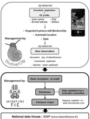
E. Objectives of the coupling with BiodiverCity application : BiodiverCity smartphone application made the data acquisition step more friendly to any users. This application is designed to let any campus user to take a photo of a wildlife occurrence and then to send it with GPS and localization to Inventaire Fac’. Before this linkage, data was collected by each users with its own camera, then downloaded on Inventaire Fac web site with individual connected computers. The BiodiverCity application permits to every campus users to send a biodiversity picture without having specific knowledge in numerical handling.
III Results
neOCampus is promoting Toulouse 3 Campus to be an operational platform for the researches occurring in this campus laboratories. By using the campus as real life field for testing research hypotheses, neOcampus is contributing at not only to inject innovation in the university ressource management for more sustainability but also should lead to the improvement of the quality of life on the campus. This project relies on a multidisciplinary scientific approach from informatique to bio-sourced concrete for buildings and outdoor spaces investigation by ecologists. This framework favored the cooperation of informatic sciences (IRIT UMR) with environmental sciences (ECOLAB UMR) for the development of BiodiverCity smartphone tool. This research team was then enlarged to the social sciences by the coupling of biodiverCity with the team of Inventaire Fac’ from Montpellier.
BiodiverCity was build in order to make the data acquisition easy enough to make it adopted by any campus citizen during its everyday life. This tool allows to send a picture made by the user when encountering a flora or fauna individual. When a picture is made with BiodiverCity, this information is automatically send with the geographical coordinates of the place where this picture is made, by using the internal GPS of each mobile phone of the users. This information is completed with the reference of the user (name, E-mail address, positions, comments, and species name) as optional additional information. After completing this first step, the users are also invited to identify the type of organisms that was encountered with a simple and short key of taxonomic identification. This short key is making possible to sort the encountered organism among the life kingdom by an easy access questions tree as, or the skin cover by hair or feathers or scales, the number of legs for animals, the shape of leaves for the trees, etc … This key makes it possible to sort the data that comes out from biodiverCity to enter in Inventaire Fac in several groups that are : Lichens, Fungi, Plants, Trees, Invertebrates, Birds, Fishes, Mammals, Amphibians, Reptiles… ) with easy access
questions such as skin covered with feathers ? Scales ? … The use of the identification key is not made as a necessity to send the data, but this additional information is making the next step of data validation more direct. The date of the observation is automatically added to the data.
When the data enter Inventair Fac’ (Figure 1) it is analysed with a web of taxonomist experts that are able to identify the organisms of the lower level in the living classification from an observation with a single picture, and to species level when it is possible. After identification, the data is integrated in the map of the campus as a contact point with the common or scientific name of the organism (figure 2). This map makes visible all the contact points that were gathered on the campus so far. This allows to visually shape the green corridors where the biodiversity is the most frequently observed in the campus. Every observation is also simultaneously stored in Inventaire Fac’s data base. Today, after BiodiverCity and Inventaire fac coupling, we are now working on the advertisement and diffusion of BiodiverCity tool on the different campus. In mai 2017, the number of contact points on the campus was 222 at Besançon, 150 at Montpellier, 140 at Toulouse, 131 at Lyon, 79 at Dijon, 76 at Versaille, 60 at Grenoble, 4 at Marseille, and 0 at Villejuif.
Inventaire Fac’ and BiodiverCity linkage helps sharing the computational facilities: the smartphone application, but also the organized data flow between the campus and the data storage capacities. In the same time, this linkage is favoring a larger participation of the people as it is no more necessary to use a camera, and then to upload the pictures from personal computers. In the other way, the data generated by BiodiverCity are benefiting now from the taxonomic identification of the organisms provided by the expert group from Inventaire Fac’.
The success of Inventaire Fac is measured by the increasing number of campus that are asking for the device to be developed on their territories. And the number of validated contact points is suggested as an indicator of the effects of the linkage with biodiverCity.
Fig 1: Example of the path of data followed by an observation with the BiodiverCity application
Fig 2: Campus maps. Example of Université de Toulouse III-Paul Sabatier campus. (available on www.inventairefac.com)
IV Short term issues :
The linkage between biodiverCity and Inventaire fac makes it possible to harvest contact data that are source of maps of frequencies and abundances of the species or groups of organisms, such as birds or amphibians. Among the next step to be achieved, the next results that should be produced are
- New maps for the spatial frequencies of dominant species.
- The evidence of hotspots of biodiversity on the campus that would be worth it to prioritize actions of conservation
- The drawing of the green and blue corridors as local reservoir of biodiversity where to set priorities of conservation for improving the reconnection of biodiversity movement through cities and between larger corridors at the national scale.
- The use of those maps and corridors in the management of the campus natural area.
The fragmentation and depletion of the surface area of the natural habitats are the main threats of biodiversity world while and even more in the urban area. Corridors are demonstrated to be fast and effective way of conserving, spreading and linking biodiversity over large areas of land while focusing on relatively small areas. They facilitate free movements of plants and animals, preserve species and prevent the fragmentation of habitats and ecosystems. Restoring connectivity is crucial in the biodiversity conservation for securing healthy, resilient and sustainable habitats and biodiversity. Campus could play active and socially inclusive role in this conservation in urban areas, specially due to the large territories they are covering. It should be noted here that corridors evidence as the major outputs from Inventaire Fac and BiodiverCity are firstly requiring contact points on the campus without deep investigations in the taxonomic identifications. In fact, the rare species are rarely captured on a picture from a non professional approach, so that the majority of the species data that are flowing through Inventaire fac are representative of a majority of commun species. However, the real need of information for giving evidence of these corridors are effectively based on the location of the higher frequencies of the contact points (that attest of the location of the natural habitats) rather than the location of the rare species. This reason makes the delivery of Inventaire Fac’ and BiodiverCity linkage being first the spatial distribution of contact points with any biodiversity, and when, it is possible the species richness arrives as an additional information with further and distinct usefulness.
An second and major effects of the development of this citizen sciences tool on the campus is then to improve sensitivity to natural habitats and biodiversity over the large spectrum of campus users from student to administrative and teaching professionals. Urban biodiversity is not well know and usually underestimated in the public evaluation. This is
also the case of the campus users and administrators that are often facing a dual choice between planted and clean garden or natural habitats with a priori less attractives area for leisure time. In this way, the integration of information coming out of Inventaire Fac’ such as hotspots and corridors of biodiversity into the negotiation for the management of the campus arrives as one more chance to increase the sensitivity for biodiversity in front of the administrative and political councils of the university and decision-makers. This awareness should lead to a better location in time and space of the different actions related to this green area. Example, if a tree needs to be cut, this action should be preferentially handled during period out of the nesting season of species detected in this area.
V. Conclusion and Long terme issues :
This first collaboration between computer scientists, ecologists and naturalist has been successful as first observations are coming through the BiodiverCity application toward Inventaire Fac’ web site.
This first experience of biodiversity data generation at a local scale is also the opportunity to train for larger data fluxes. Today biodiversity data are produced in a increasing numbers of organisations that should all flow until national data bases The SINP (Information system on nature and landscape) and ECOSCOPE (Observation for research on biodiversity data hub) are two distinct scientific infrastructures on biodiversity in France [11]. In the last report of ECOSCOPE [12], the weakness of these national devices is at the level of the new data implementation in this metadata bases. Without solving this question at the scale of the national harvesting, one of the next step of our local experience could be to apply the scientific cooperation of Inventaire Fac and BiodiverCity to implement the flux of data coming out from this initiative into this type of metadata infrastructures.
Acknowledgement
This work was supported by the neOCampus operation of University Paul Sabatier, leaded by Marie-Pierre Gleize. Inventaire Fac device was developed with the help of the REFFED3.
Bibliographie
[1] Butchart, S. H. M., Walpole, M., Collen, B., van Strien, A., Scharlemann, J. P. W., Almond, R. E. E., et al. (2010). Global
biodiversity: Indicators of recent declines. Science 328,
1164–1168.
[2] Bœuf, G., Allain, Y.-M. et Bouvier, M., 2012. L’apport
des sciences participatives dans la connaissance de la biodiversité. Rapport remis à la ministre de l’Écologie.
[3] Marques, A., Pereira, H. M., Krug, C., Leadley, P. W., Visconti, P., Januchowski-Hartley, S. R., Walpole, M. (2014).
A framework to identify enabling and urgent actions for the 2020 Aichi Targets. Basic and Applied Ecology, 15(8),
633-638. DOI: 10.1016/j.baae.2014.09.004
[4] Secretariat of the Convention on Biological Diversity 2000 Sustaining life on Earth. Edition CBD, 20 p., ISBN 92-807-1904-1
[5] Scholes, R.J., Gill, M.J., Costello, M,J., Sarantakos, G., Walters, M., 2017. Working in Networks to Make Biodiversity Data More Available. The GEO Handbook on Biodiversity
Observation Networks, pp 1-17.
[6] Chandler, M., See, L., Buesching, C.D., Cousins, J.A., Gillies, C., Kays, R.W., Newman, C., Pereira, H.M., Tiago, P., 2017. Involving Citizen Scientists in Biodiversity
Observation. The GEO Handbook on Biodiversity
Observation Networks, pp 211-237.3
[7] Haklay, M 2015. Citizen Science and Policy: A European
Perspective. Washington, DC: Woodrow Wilson International
Center for Scholars.
[8] Mathieu, D., 2012, Opportunités et dynamique des
programmes de science participative , La Lettre de l’OCIM,
144 |, 25-32.
[9] Schmeller D. S. , C. Arvanitidis, M. Böhm, N. Brummitt, E. Chatzinikolaou, M. J. Costello, H. Ding, M. J. Gill, P. Haase, R. Julliard, J. García-Moreno, N. Pettorelli, C. Peng, C. Riginos, U. Schmiedel, J. P. Simaika, C. Waterman, J. Wu, H. Xu and J. Belnap 2017 Case Studies of Capacity Building for Biodiversity Monitoring. The GEO Handbook on Biodiversity Observation Networks, pp 309-326.
[10] Bagnolini G., Inventaire fac’ : un programme de science participative sur les campus étudiants, Cahiers de l’action,
1/2016 (N° 47), p. 47-53
3
https://refedd.org
[11] Taffoureau, E., A. Cohen Nabeiro and J. Touroult 2016
Metadata on Biodiversityಞ: Definition and Implementation
FRB, Proc. Int’l Conf. on Dublin Core and Metadata
Applications.
[12] FRB 2016 Etat des Lieux et analyse du paysage des
observatoires francais de recherche sur la biodiversité.