Assessment of the effectiveness of soil and water conservation measures in reducing runoff and soil loss: establishment of a European database
W. Maetens (1), M. Vanmaercke(1) , J. Poesen(1)
(1)Departement of Earth and Environmental Sciences, Katholieke Universiteit Leuven, Celestijnenlaan 200E, 3001, Heverlee (Belgium). E-mail: willem.maetens@ees.kuleuven.be
ABSTRACT
Soil erosion by water is recognised as a major soil degradation process that requires a global approach. Large regions all over the world are in need of integrated conservation strategies that sustainably prevent and remediate soil erosion. Therefore, quantitative and globally interpretable data are needed in support of models and decision making. The effects of various soil and water conservation techniques (SWCT) on runoff and soil loss in Europe have been extensively studied over the last 60 years. Runoff plots are the most widely used measurement technique to study the effects of SWCT on runoff and soil loss by water erosion. Hence, many data are available. However, the insights gained hereby remain mostly local and often qualitative whereas the full potential of the available data is not exploited yet. This is mainly due to the fragmentation of knowledge and extrapolation difficulties inherently linked with this type of data.
This study addresses the issue of the availability of quantitative runoff and soil loss data from plot measurements in Europe and the quantitative assessment of the effectiveness of various SWCT in reducing runoff and soil loss. In the framework of the EU-DESIRE project, a database is currently compiled. The database currently contains 3175 plot-year data on runoff and soil loss measurements from 108 study sites in Europe and the Mediterranean. The SWCT documented herein include crop rotations, conservation tillage, cover cropping, mulching, vegetated buffer strips and terraces. From this dataset, an evaluation can be made of the effectiveness of various SWCT in reducing runoff and soil loss by water for a range of environmental conditions in Europe. A first example, regarding the effectiveness of SWCT in olive orchards, is discussed in this paper.
Keywords: desertification, water erosion, runoff plot, soil and water conservation
INTRODUCTION
The use of SWCT as part of sustainable agricultural practices is an important tool in the ongoing struggle against land degradation and desertification. Several national and international projects have studied the use of SWCT and propagated their effective use (e.g. MEDALUS, DESIRE). Several approaches to document their applications like the World Overview of Conservation Approaches and Techniques (WOCAT) exist. However, the effects of these measures in mitigating soil erosion are often deduced from local experience. The overall effectiveness of these SWCT is rarely represented in quantitative way. Nonetheless, many such data are available, albeit dispersed in the literature, and these data can greatly help land users, planners and decision makers to optimize the application of SWCT. Therefore, a database of runoff and soil losses by sheet and rill erosion, measured on plots throughout Europe is being compiled as part of the international DESIRE project.
Apart from providing an insight into the effectiveness of SWCT, the data can be further used for the calibration and validation of erosion models in a European context, e.g. in the case of the widely used Revised Universal Soil Loss Equation (RUSLE). RUSLE was initially developed for conditions of medium-textured, non-stony soils and the climatic conditions of its home ground in the American Midwest (Wischmeier and Smith, 1978). While there are
regions in Europe that meet these conditions, others (like Northern Europe, the Alpine regions and the Mediterranean) do not Therefore, application of RUSLE in these regions requires the adjustment of parameter values.
METHODS
Plot-scale runoff and soil loss data are collected through a detailed literature review of journals, books, PhD theses, internal project reports and through correspondence with researchers collecting runoff and soil loss data from plots. One entry in the database corresponds to the combination of one land use, without or with SWTC for a specific location and measurement period.
For each recorded entry, the database contains the following data: (1) source(s) of the data (author(s), reference), (2) measurement site details (location, land use, SWCT evaluated in the experiment, plot dimensions, slope gradient, annual precipitation (mm), soil characteristics (type, texture, organic matter content), vegetation type and density), (3) measurement period (plot years) and (4) runoff and soil loss measurements (annual plot runoff (mm/year), runoff coefficient (%/year), soil loss (Mg/ha.yr)).
RESULTS AND DISCUSSION
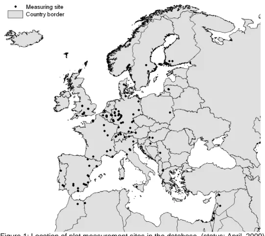
The database currently comprises 3 175 plot-year data (i.e. data collected at one plot during one year) at 108 sites throughout Europe and the Mediterranean (Figure 1).
Figure 1: Location of plot measurement sites in the database. (status: April, 2009)
The distribution of the plot sites over the climatic zones in Europe (Table 1) is not homo-genous, with the Artic, Alpine and Steppic environments being underrepresented. However, most erosion-prone regions have been extensively studied, making the database representative for the effectiveness of SWCT where water erosion is problematic.
Artic Boreal Atlantic Alpine Mediterranean * Continental Steppic TOTAL
N° of sites 0 12 38 3 30 25 0 108
Table 1: Distribution of measurement sites over the climatic zones. Climatic zones are defined by Metzger et al., 2005. *; North, South and East Mediterranean (status: April, 2009)
Slope lengths of the plots in the database vary between 5 m and 175 m, and plot areas between 5 m² and 43750 m². The slope gradient varies between 1.8% and 65% and measurement periods range from 1 growing season to 17 consecutive years. All runoff and soil loss data were recorded under natural rainfall. Currently, the SWCT contained in the database consist of measures that either increase soil cover (i.e. cover and catch crops, strip cropping, crop residue, different types of mulches and geotextiles), improve soil management (i.e. different types of conservation tillage depending on the equipment, depth and frequency of tillage operations, contour tillage and drainage) and mechanical measures (i.e. terraces and buffer strips).
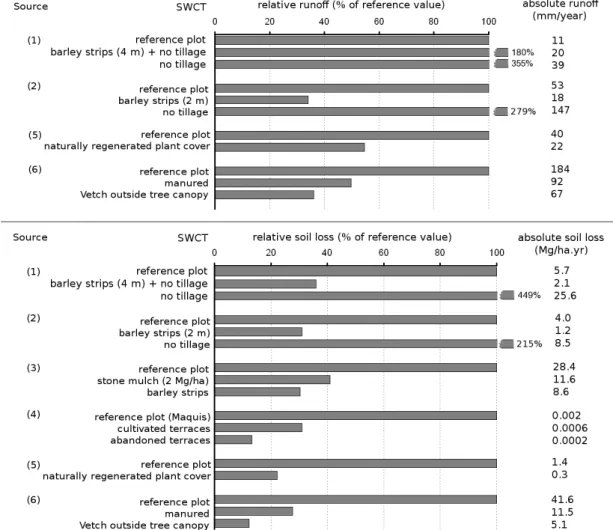
As an example of a first analysis, the comparison of the effectiveness of selected SWCT in olive orchards is presented in Figure 2. The conventional cultivation practices at the research site serve as reference and corresponding runoff and soil loss are set equal to 100%. The effectiveness of specific SWCT in reducing runoff and soil loss is then represented relative to these reference values. Absolute values of runoff (mm/yr) and soil loss (Mg/ha.yr) are given for further illustration.
_______________________________________________________________________________________________________
Figure 2: Comparison of the effect of different SWCT on relative and absolute annual runoff (upper) and soil loss (lower) in olive orchards (n=62 plot years). The reference value is the value for the conventional practice at the research site and is set to 100%. Sources of data: (1) Francia-Martinez et
al., 2006; (2) Gomez et al, 2004; (3) Aspizu, 2003; (4) Arhonditsis et al., 2000; (5) Ordóñez-Fernández et al., 2007; (6) Bruggeman et al., 2005
Apart from no tillage, the selected SWCT all reduce runoff and soil loss with respect to the reference plots. The application of no tillage causes higher bulk densities in the topsoil and lower infiltration rates (Francia-Martinez et al., 2006), which in turn causes the higher runoff rates (Source 1 and 2). This effect can be reduced by combining no tillage with vegetation strips (Source 1). Furthermore, it is shown that for the selected studies, the SWCT are more effective in reducing soil losses than they are in reducing runoff.
CONCLUSIONS
The quantification of the effectiveness of SWCT in reducing runoff and soil losses from water erosion is made possible through the establishment of a database containing runoff and soil loss data collected on erosion plots. As is commonly assumed, most of the applied SWCT are found to mitigate runoff and soil loss, but they differ in effectiveness depending on the local conditions. Therefore, the final database will also serve as a tool for the optimization of the choice for specific SWCT in a given context.
ACKNOWLEDGMENTS
The authors wish to thank all researchers who provided publications and further information concerning the plot measurements in this study. The research described in this paper was conducted in the framework of the EC-DG RTD- 6th Framework Research Programme (sub-priority 1.1.6.3) - Research on Desertification- project DESIRE (037046): Desertification Mitigation and Remediation of land – a global approach for local solutions.
REFERENCES
Arhonditsis, G., Giourga, C. & Loumou, A. 2000. Ecological Patterns and Comparative Nutrient Dynamics of Natural and Agricultural Mediterranean-Type Ecosystems. Environmental Management. 26(5), 527-573.
Aspizu, R. 2003. Erosion Assessment and Conservation Measures in Sloping and Mountainous Olive Production Systems in Andalucía. OLIVERO Student Report Series N°2
Bruggeman, A., Masri, Z., Turkelboom, F., Zöbisch, M. & El-Naeb, H. 2005. Strategies to sustain productivity of olive groves on steep slopes in the northwest of the Syrian Arab Republic, In Benites, J., Pisante, M. and Stagnari, F. (Eds.) Integrated soil and water management for orchard
development, FAO Land and Water Bulletin 10, 75-101.
Francia Martínez, J.R., Durán Zuazo, V.H. & Martínez Raya, A. 2006. Environmental impact from mountainous olive orchards under different soil-management systems (SE Spain). Science of the
Total Environment. 358, 46-60.
Gomez, J.A., Romero, P., Giráldez, J.V. & Fereres, E. 2004. Experimental assessment of runoff and soil erosion in an olive grove on a Vertic soil in southern Spain as affected by soil Management. Soil
Use and Management. 20, 426-431.
Metzger M.J., Bunce R.G.H, Jongman R.H.G, Mücher C.A. & Watkins J.W. 2005. A climatic stratification of the environment of Europe. Global Ecology and Biogeography. 14: 549-563.
Ordóñez-Fernández, R., Rodríguez-Lizana, A., Espejo-Pérez, A.J., González-Fernández, P. & Saavedra, M. 2007. Soil and available phosphorus losses in ecological olive groves. Europ. J. Agronomy. 27, 144–153.
Wischmeier, W. & Smith, D. 1978. Predicting rainfall erosion losses: A guide to conservation planning.