Recent sedimentation in three adjacent fjord-lakes on the Québec North Shore (Eastern 1
Canada): facies analysis, laminae preservation and potential for varve formation 2
Obinna P. Nzekwe, Pierre Francus, Guillaume St-Onge, Patrick Lajeunesse, David Fortin, Antoine G. 3
Poiré, Édouard G. H. Philippe, Alexandre Normandeau 4
O. P. Nzekwe1 and P. Francus. Institut National de la Recherche Scientifique, Centre - Eau Terre 5
Environnement, Québec, QC G1K 9A9, Canada, Canada Research Chair in Environmental 6
Sedimentology & GEOTOP 7
Email: [email protected] 8
Email: [email protected] 9
G. St-Onge. Institut des sciences de la mer de Rimouski (ISMER), Université du Québec à Rimouski, QC 10
G5L 2Z9, Canada, Canada Research Chair in Marine Geology & GEOTOP 11
Email: [email protected] 12
P. Lajeunesse and A. G. Poiré.Centre d’études nordiques, Département de géographie, Université Laval, 13
Québec, G1V 0A6, Canada 14
Email: [email protected] 15
Email: [email protected] 16
D. Fortin.School of Earth Sciences and Environmental Sustainability, Northern Arizona University, 17
Flagstaff, AZ 86011, USA 18
Email: [email protected] 19
Édouard G. H. Philippe. Institut des sciences de la mer de Rimouski (ISMER), Université du Québec à 20
Rimouski, Canada and Institut de Physique de Globe de Paris, Paris, France & GEOTOP 21
Email: [email protected] 22
A. Normandeau. Geological Survey of Canada (Atlantic), Bedford Institute of Oceanography, 23
Dartmouth, Nova Scotia B2Y 4A2, Canada 24
Email: [email protected] 25
1
Corresponding author. Email: [email protected] 26
Keywords: Limnogeology, sedimentary structures, laminations, varves, CT-scan, Québec North 27
Shore 28
Submitted to the Canadian Journal of Earth Sciences 29
30
Abstract 31
This paper analyzes short gravity cores sampled along transects in three adjacent deep fjord-32
lakes (lakes Pentecôte, Walker and Pasteur) on the Québec North Shore, Eastern Canada, in 33
order to evaluate the distribution of laminated sediments and potential for varve formation. 34
Facies analysis based on lithological description, digital photos, CT-scan images and 35
bathymetric data allowed for the identification of four main sediment facies, namely: laminated 36
sediments, partially laminated sediments, bioturbated sediments, and massive sediments. Direct 37
evidence that Lake Walker undergoes thermal stratification was monitored from 2014–2016. 38
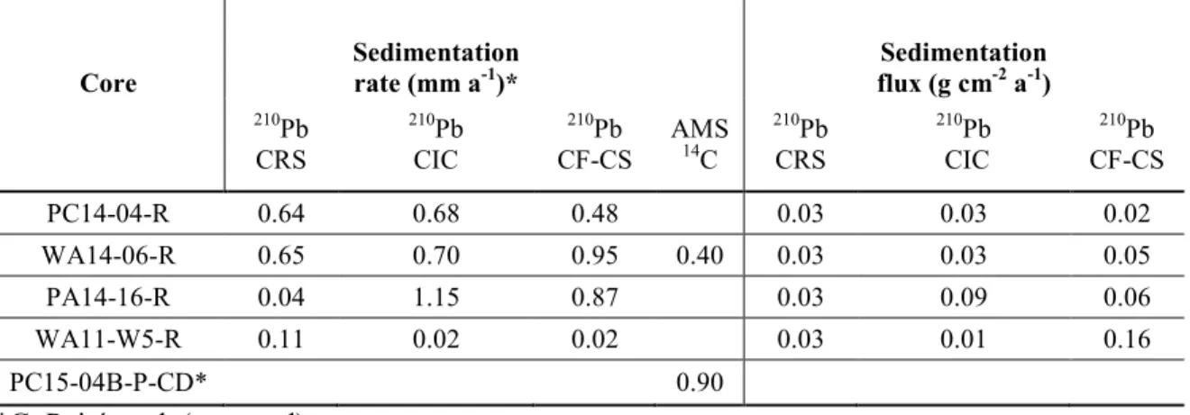
Mean sedimentation rates and sedimentation fluxes of postglacial sediments in the distal basin of 39
the three studied lakes are < 0.12 cm a-1 and 0.03–0.16 g cm-2 a-1, respectively based on 210Pb, 40
137
Cs and AMS radiocarbon dating. On the basis of thin section image analysis and 210Pb (CIC) 41
chronology model, Lake Pentecôte contains mainly massive–partially laminated sediments, 42
while Lake Pasteur contains partially laminated sediments and non-annual varve-like sediments. 43
However, Lake Walker contains laminated sediments that are likely varves. The increased 44
potential for laminae preservation observed in Lake Walker compared to lakes Pentecôte and 45
Pasteur is associated with more favourable morphological characteristics including higher 46
relative depth, mean depth, maximum depth and topographic exposure. 47 48 49 50 51 52 53
Introduction 54
Lacustrine environments are subject to physical, chemical and biological processes that 55
influence the nature of sediment deposition (Schnurrenberger et al. 2003; Tylmann et al. 2012; 56
Zolitschka et al. 2015). Lake sediments are characterized by sedimentary facies that reflect the 57
processes driving their deposition such as settling, wind-, or density-driven currents (Tylmann et 58
al. 2012). Sedimentary structures such as laminations can be particularly useful for 59
paleoenvironmental reconstructions when they are annually laminated, i.e. formed by seasonal 60
deposition of autochthonous (formed within the lake basin) and/or allochthonous (transported 61
from the watershed to the lake basin) materials under favourable conditions (Larsen and 62
MacDonald 1993; O'Sullivan 1983; Saarnisto 1986; Zolitschka et al. 2015). However, the 63
combination of several environmental and morphological conditions facilitate the preservation of 64
laminations: (1) the absence of sediment-water mixing due to wave or wind-driven circulations, 65
(2) presence of gentle to flat lake bottom that reduces the frequency of mass movements, (3) a 66
deep basin that favours seasonal or permanent axonia, (4) reduced biological activity of benthic 67
organisms, (5) a seasonally contrasted sedimentary supply, and (6) sufficient sedimentation rates 68
(Jenny et al. 2013; Larsen and MacDonald 1993; Larsen et al. 1998; O'Sullivan 1983; 69
Schnurrenberger et al. 2003; Tylmann et al. 2012; Wetzel and Likens 1991; Zolitschka et al. 70
2015). It has been argued that there is a relationship between the distribution of laminated 71
sediments and the lake morphometry (Zolitschka et al. 2015). Several authors have reported 72
empirical assumptions using morphometric variables in order to improve the chances of 73
recovering laminated sediments during reconnaissance field surveys or in areas where prior 74
studies are relatively limited (e.g. (Gorham and Boyce 1989; Larsen and MacDonald 1993; 75
Larsen et al. 1998; O'Sullivan 1983; Ojala et al. 2000; Zolitschka et al. 2015). 76
On the Québec North Shore, in the southeastern Canadian Shield (Eastern Canada), three 77
lakes (lakes Pentecôte, Walker and Pasteur) were studied for the possible occurrence of annually 78
laminated sediments. High-resolution swath bathymetry, subbottom acoustic profiles and 79
sediment cores were collected to reconstruct the Late Quaternary geomorphological evolution of 80
these fjord-like lakes in response to deglaciation and postglacial sedimentary processes 81
(Gagnon-Poiré 2016; Normandeau et al. 2016). In this paper, short gravity cores retrieved from 82
these three adjacent lakes are analysed in order to evaluate laminae preservation and the 83
potential for varve formation. The specific objectives are to: (1) identify the sedimentary facies 84
present in the short gravity cores and assess their distribution and depositional environments, and 85
(2) evaluate laminae visibility, sedimentation rates and the potential for establishing a varve 86
chronology in the uppermost sediments from the lakes, using radiometric dating (210Pb and 87
137
Cs) and image analysis of thin sections. 88
Regional setting 89
Lakes Pentecôte, Walker, and Pasteur are located on the Québec North Shore, in the 90
northwestern Gulf of St. Lawrence in Eastern Canada (Fig. 1). In the local context, the studied 91
lakes are located within the Reserve faunique de Port-Cartier–Sept-Îles. They have been fairly 92
undisturbed by anthropogenic activities such as dredging or hydropower generation, except for 93
controlled fishing, boating and wood harvesting. The maximum depths of lakes Pentecôte, 94
Walker and Pasteur are 130, 271 and 70 m, respectively (Gagnon-Poiré 2016); their elevation 95
above sea level (asl) is 84, 115 and 86 m, respectively. The studied lakes have steep sidewalls 96
and relatively deep bottoms, forming a fjord-type morphology. The lakes lie below the limit of 97
the deglacial transgression associated with glacio-isostatic depression, which is at 130 m asl in 98
the region (Dredge 1983). 99
The Québec North Shore region has a subarctic climate where spring snowmelt, which 100
constitutes the peak of the annual runoff period, occurs usually between April and May. The 101
studied lakes are typically covered by ice from December until April. The lake basins receive 102
seasonal inflows from major rivers and small streams that drain areas covered with glacial fine 103
and marine sediments (Fig. 1). In Lake Walker, the Schmon and Gravel rivers flow into the 104
northwestern and northeastern parts, respectively (Fig. 1). Lakes Pentecôte and Pasteur are 105
principally fed by Pentecôte and Pasteur rivers that both flow into their northern parts (Figs. 1). 106
Land cover is largely a boreal forest comprising fir, black spruce, poplar, aspen and shrubs. 107
Morphological and other characteristics of the lakes are shown in Table 1. 108
The Québec North Shore region lies within the geologic province of Greenville. Bedrock 109
geology consists of Precambrian rocks that are Archean or Proterozoic in age (Ministère des 110
ressources naturelles du Québec 2002). Archean rocks comprise migmatite and gneiss, which 111
contain plagioclase, biotite and/or hornblende and/or amphibolite. Proterozoic rocks comprise 112
mafic to ultramafic rocks, as well as sedimentary rocks, which contain paragneiss and quartzite 113
(Ministère des ressources naturelles du Québec 2002). Gneissic rocks underlie most parts of 114
lakes Walker and Pentecôte watersheds, while paragneissic rocks underlie most parts of Lake 115
Pasteur. The history of the sedimentation in the watersheds of studied lakes during the transition 116
from late Quaternary glacial to postglacial has been discussed by Gagnon-Poiré (2016), 117
Normandeau et al. (2016) and G. Poiré et al. (accepted). The fjord-type lakes in the southeast 118
Canadian Shield region have been formed by preglacial fluvial erosion during a lower base level, 119
which carved out V-shaped valleys subsequently occupied by Quaternary sediments preserved 120
below the Laurentide Ice Sheet (LIS) (Lajeunesse 2014). 121
Methods and materials 122
Fieldwork and sediment coring 123
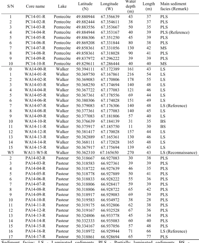
Short sediment cores ranging from 30 to 100 cm were collected from lakes Pentecôte, Walker 124
and Pasteur in June 2014. Efforts were made to carefully retrieve undisturbed sediment/water 125
interface from suitable locations based on multibeam bathymetry and subbottom profiler data, 126
which provided insight on the lake basin morphology and nature of sediment deposition. 127
Detailed information on high-resolution subbottom acoustic data from the three studied lakes 128
have been presented by Gagnon-Poiré (2016) and G. Poiré et al. (accepted). Sediment cores were 129
obtained in the central and southern parts of Lake Pentecôte and along two transects in the 130
northern part of Lake Walker (Figs. 2A and 2B). Coring was restricted to the northern part of 131
Lake Pasteur due to limited accessibility (Fig. 2C). A free fall gravity corer (modified after 132
(Hvorsley and Stetson 1946) equipped with metal bars as load was used to improve sediment 133
penetration at depths. In total, 42 short gravity cores were collected: 10 cores at Lake Pentecôte, 134
16 at Lake Walker and 16 at Lake Pasteur (Table 2). The sediment cores were collected on board 135
a pontoon boat on lakes Pentecôte and Walker and from an inflatable boat on Lake Pasteur. All 136
boats were positioned with DGPS systems (ca 60 cm precision; Hemisphere GPS, Calgary, 137
Canada). 138
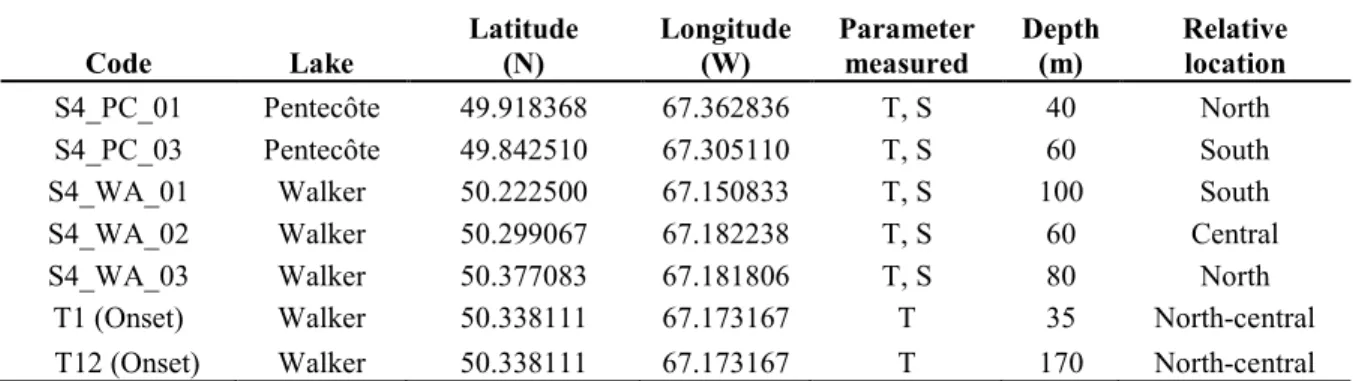
Temperature sensors (Onset Hobo Water Temp Pro v2 and Tidbit v2 models) were 139
deployed in Lake Walker on June 5th 2014, in order to determine whether the lake undergoes 140
thermal stratification. The deployment location (50°23'17.2" N, 67°10'23.4'' W) was chosen for 141
its relative proximity to the area of coring and to the inflow of the two rivers in the northern part 142
of the lake (Fig. 2B). The temperature sensors were placed along a polypropylene rope and set to 143
take readings every hour for a two-year period, after which they were retrieved. To ensure 144
upright suspension of the sensors, a load (concrete block) was tied to the base of the mooring 145
while two buoys located 20 m apart were attached at the upper end of the rope. 146
On September 25th 2014, during another fieldwork, an S4 current meter (InterOceans 147
Systems Inc. USA) was used to measure temperature and salinity. Two measurements were 148
collected at Lake Pentecôte and three at Lake Walker, at points where the water depths ranged 149
from 40 to 100 m (Table 3). None were collected at Lake Pasteur due to logistical constraints. 150
Computed tomography and digital photography 151
Whole core sections were analyzed using a SIEMENS SOMATOM Definition Volume 152
Access sliding gantry medical CT-scanner at the Institut National de la Recherche Scientifique, 153
Centre Eau Terre Environment (INRS-ETE). The CT-Scan allowed for the non-destructive 154
acquisition of longitudinal and transverse images showing the internal structures of the cores. 155
The acquisition was performed at a voltage of 140 keV, current of 410 mA and a rotation time of 156
1000 ms/rot. The resulting images were displayed in gray scale, with lighter and darker areas 157
indicating higher and lower X-ray attenuations, respectively. Gray scale values are expressed as 158
CT numbers or Hounsfield units (HU). X-ray attenuation is related to sediment bulk density, 159
porosity and mineralogy (Boespflug et al. 1995; Cremer et al. 2002; Fortin et al. 2013). Analysis 160
of CT-scan images was done using the Siemens software or the Image J software (Schneider et 161
al. 2012). 162
Shortly after splitting and prior to oxidation of the sediment core surface, the split 163
sediment cores were photographed with a GEOTEKTM Geoscan IV line-scan camera (50-µm 164
pixel size) mounted on a GEOTEKTM Multi-Sensor Core Logger (MSCL; Geotek Ltd., UK.) at 165
the Institut des sciences de la mer de Rimouski (ISMER), Canada. Subsequently, another high-166
resolution line camera mounted on an ITRAX core scanner (Cox Analytical Systems, Sweden) at 167
INRS-ETE was used to acquire RGB colour images (50-µm pixel size) of the split cores. The 168
advantage of the latter over the former is that the images are relatively free from the effects of 169
glare from water on the sediment surface, due to polarizers of the ITRAX. 170
Facies- and image analysis 171
Sediment cores were described and grouped into facies based on qualitative identification 172
of textural properties such as colour, grain size and sedimentary structures through a 173
combination of visual inspections, digital photos, CT-scan images and ITRAX line scan images. 174
Colour of sediments was expressed based on the Munsell Soil Colour Chart (Munsell Color 175
Xrite). A qualitative index, the “Lamination visibility index (LVI)” was introduced to describe 176
the visibility of laminations, as observed from the digital images, with values as follows: 0 - 177
none, 1 - faint, 2 - visible, 3 - clear, and 4 - distinct. One reference core was selected for each 178
lake based on the presence of laminations and evidence of minimal sediment disturbance, 179
namely PC14-04-R (Pentecôte), WA14-06-R (Walker) and PA14-16-R (Pasteur), respectively. 180
Undisturbed sections were subsampled from the selected reference cores using 181
overlapping metal slabs made of thin aluminium (measuring 18 x 1.5 x 0.5 cm), and thin 182
sections were made based on freeze-drying and epoxy-resin embedding techniques (Francus and 183
Asikainen 2001). Image observation of scanned thin-section slabs was performed using software 184
developed at INRS-ETE (Francus and Nobert 2007). This allowed for further description of the 185
laminae visibility (using the LVI index), and for microscopic counting of laminations on the 186
digital scans (Francus 2006). Laminae were counted by two independent researchers and 187
counting error (%) was estimated based on the difference in the number of counted laminae 188
couplets along the thin sections (Zolitschka et al. 2015). 189
Sediment dating 190
For 210Pb analysis, the upper 10 cm section of the three reference cores was sampled at 191
intervals of 0.4 cm. In addition, another core, WA11-W5-R that was retrieved ∼2 km southeast 192
of core WA14-06-R during a reconnaissance survey in Lake Walker in 2011, was included in the 193
analysis for comparison (hereafter referred to as reconnaissance core, Fig. 2B). Core WA11-W5-194
R was previously sampled at intervals of 0.5 cm. Freeze–dried samples (ca. 2g) were analysed 195
for 210Pb activity using a high-resolution germanium diode gamma detector and multichannel 196
analyzer gamma counter at the Centre d’études Nordiques (CEN), Université Laval (Canada) for 197
core WA11-W5-R, and subsequently with a similar instrument at INRS-ETE for the reference 198
cores. 210Pb activities were analysed as function of depth expressed in form of cumulative dry 199
mass in order to account for the effect of compaction (Appleby and Oldfield 1978). The profiles 200
of 210Pb unsupported were used as input for three possible dating models: (1) the constant rate of 201
sedimentation (CRS) model that takes into account variable sedimentation rates, but constant 202
fluxes of 210Pb, (2) the constant initial concentration (CIC) model that simultaneously takes into 203
account varying sedimentation rates and fluxes of 210Pb, and (3) the constant flux - constant 204
sedimentation model (CF-CS) that simultaneously takes into account constant rate of 205
sedimentation and input of 210Pb (Appleby et al. 1979; Robbins and Edgington 1975). 206
Confidence intervals were calculated by first-order error analysis of counting uncertainty 207
(Appleby and Oldfield 1978; Appleby et al. 1979). This was done in order to determine the age 208
(a), sedimentation rate (cm a-1), and sediment (mass) accumulation rates (g cm-2 a-1) for the past 209
∼150 years (Zolitschka et al. 2015). 137Cs was used to identify sediments deposited during the 210
peak of atmospheric nuclear testing between the periods from 1963 to 1964 (Appleby and 211
Oldfield 1978). 212
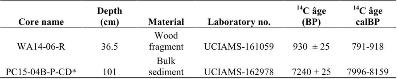
Terrestrial plant macrofossils (wood fragments) were collected from core WA14-06-R at 213
a depth of 36.5 cm. Bulk sediment from another core, PC15-04B-P-CD that was sampled from 214
Lake Pentecôte in 2015 was included for comparison (G. Poiré et al. accepted). The samples 215
were prepared at CEN and analysed using accelerator mass spectrometry (AMS) at the Earth 216
System Science Department Keck Carbon Cycle AMS Facility at the University of California at 217
Irvine. The dates were calibrated using the Calib 7.1 software using the INTCAL2013 (Stuiver 218
and Reimer 1993) and are presented with 2 sigma standard deviation (Table 4). 219
Loss on ignition 220
Within the intervals sampled for 210Pbdating, sediments were extracted to perform loss-221
on-ignition (LOI) measurements. Organic matter content was calculated as the difference in 222
weight between sediment dried at 60 °C and the ash produced after ignition at 550 °C for 4 223
hours. Furthermore, the percentage of calcium carbonate was calculated as the difference in 224
weight between ash produced after ignition at 550 and 1000 °C within a high temperature 225
furnace (Heiri et al. 2001). 226
Results 227
Physical limnology 228
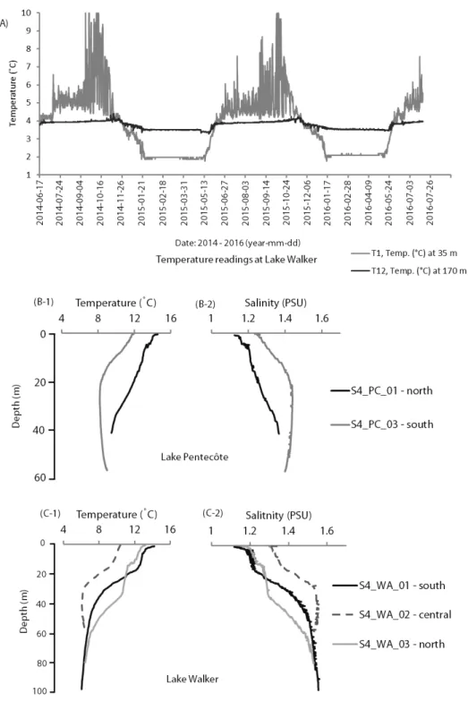
Figure 3A shows a clear evidence of temperature variations measured at 35 and 170 m depths 229
(below water level) over a 2-year period (June 5th 2014 – August 4th 2016) in Lake Walker. In 230
the upper part of the lake (∼35 m), temperature varied between 3.4 and ∼7.0 °C and fluctuated 231
intermittently to 10.0 °C between June and November. It decreased from 3.4 to 2.0 °C during 232
winter. In the lower part of the lake (∼170 m), temperature was ∼4 °C between June and 233
November, decreasing to ∼3.5 °C during winter. Lake mixing, evidenced by temperature 234
reversals across the two depth intervals, occurred twice each year, in May and November, which 235
correspond to the time of ice breakup and ice formation, respectively. 236
Figures 3B and 3C shows point measurements of temperature and salinity in lakes 237
Pentecôte and Walker measured in September 2014 (Table 3). In Lake Pentecôte, profiles from 238
the northern (S4_PC_01) and southern (S4_PC_03) parts of the lake show a temperature 239
decrease from ∼15–12 °C at the surface and ∼12–8 °C at 20 meters, and slight increase in 240
salinity from 1.1–1.3 and 1.8–1.9 PSU. Between 20 and 40 m, the northern profile indicates a 241
temperature trend from ∼12–9 °C, and slight increase in salinity from 1.2–1.3 PSU, while the 242
southern one shows that towards ∼60 m depth, temperature and salinity steadied at ∼8 °C and 243
∼1.4 PSU, respectively. 244
In Lake Walker, profiles from the southern (S4_WA_01) and northern (S4_WA_03) 245
parts show comparable trends between 0–60 m: temperature decreases from ∼14–8°C and 246
salinity increases slightly from 1.2–1.4 PSU. Further down, the three parameters stabilize. 247
However, a profile from the central (S4_WA_02) part of the lake indicates that within 0–30 m, 248
temperature decreases from 11–6 °C, while salinity increases slightly from 1.3–1.5 PSU (Figs. 249
3C-1 and 2). These data show that thermal stratification occurs in Lake Walker. 250
Sedimentary facies 251
The following distinct sedimentary facies were identified based on qualitative analysis: 252
laminated, partially laminated, bioturbated and massive sediments. Rapidly deposited layers and 253
turbidite deposits were also identified (Figs 2, 4 and 5). 254
Laminated sediments (LS) 255
The two basic units that compose the laminated sediment facies are a silty minerogenic material 256
(silty lamina) and a clay and organic rich material (clayey lamina). The silty lamina is grayish 257
brown to dark gray (Munsell colour: 2.5Y 5/2 to 4/2), whereas the clayey lamina is dark gray to 258
very dark gray (Munsell colour: 2.5Y 5/2 to 3/2). LS facies have visible to distinct laminations 259
(LVI index 2–4). The thickness of lamina couplets ranges from 0.2 to 1 cm. Laminations are 260
usually horizontal, although sometimes inclined due to disturbance during deposition or coring 261
and transportation. CT number varies from 1100 to 1500 HU (Fig. 5). 262
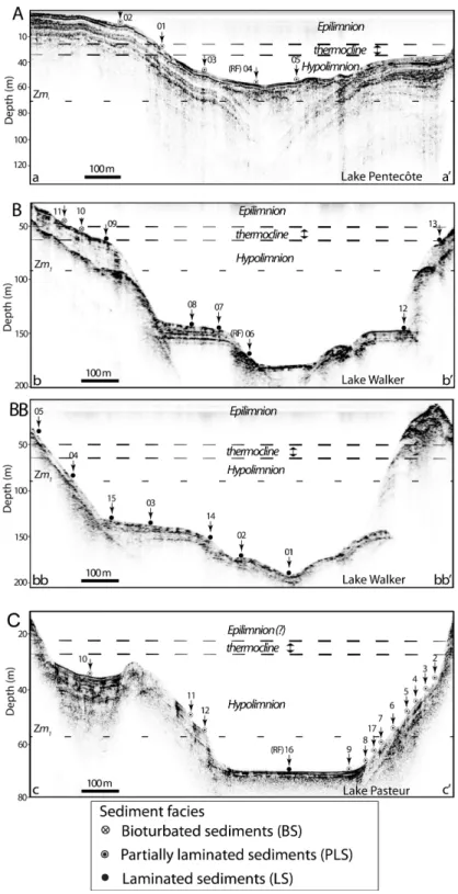
The distribution of the LS facies in the three lakes is shown on Figures 2 and 4. Of the 263
ten short sediment cores collected from Lake Pentecôte, none were laminated along its entire 264
length. In Lake Walker, 81% (13 out of 16) of cores were characterised entirely by the LS facies. 265
These cores were retrieved at water depths ranging from 60 to 270 m, which correspond to the 266
deep central part of the lake basin (Figs. 2B, 4B and 4BB). In Lake Pasteur, 6% (1 out of 16) of 267
cores contained LS facies along the entire core. It was retrieved at a depth of 70 m, which 268
corresponds to the deepest part of the lake’s basin (Figs. 2C and 4C). 269
Partially laminated sediments (PLS) 270
Partially laminated sediments comprise olive gray silty lamina and dark to very dark olive gray 271
clayey lamina (Munsell colour: 5Y 3/15 and Y 4/2 to 3/2, respectively). They are characterized 272
by similar grain size as the LS facies, but with parallel or inclined laminations that range from 273
faint to clear (LVI index 1–3) at intervals within the same core (Fig. 5). Laminae thickness 274
ranges from 0.4 to 1 cm. Wood fragments are more common in the PLS than in the LS facies. 275
CT number varies from 1200 to 1600 HU. 276
In Lake Pentecôte, partially laminated sediments characterized 80% (8 out of 10) of 277
collected cores. The cores were retrieved from water depths ranging from 39–130 m, 278
representing the shallow to deep parts of the lake (Figs. 2A and 4A). In Lake Walker, none were 279
partially laminated, while in Lake Pasteur, 94% (15 out of 16) of sediment cores were partially 280
laminated. They were collected at water depths ranging from 28–48 m, representing the shallow 281
to moderately deep parts of the lake (Figs. 2C and 4C). 282
Bioturbated sediment (BS) 283
Bioturbated sediments are marked by colour mottling, with variation from light yellowish brown 284
to light olive brown and gray to dark grayish brown silty clay and clay materials (Munsell 285
colour: 10YR 6/4 to 4/1, 2.5Y 6/1 to 5/2). The laminations appear faint to visible (LVI index 1– 286
2) and are parallel to inclined, sometimes disturbed. CT number ranges from 1400 to 1500 HU 287
(Fig. 5B). 288
The BS facies was encountered in the upper part of two cores from Lake Walker, which 289
were retrieved at depths of 10–30 m that correspond to the proximal and shallow parts of the 290
lake (Figs. 2B and 4B). 291
Massive sediments (MS) 292
Massive sediments consist of olive gray and dark gray silty and clayey materials (Munsell 293
colour: 5Y 4/2 to 4/1, respectively). There is no clear evidence of visible laminae pattern though 294
faint laminations (LVI index 0-1) are occasionally present (Fig. 5E). This facies contains organic 295
materials such as wood fragments and deformations due to gas expansion that were more evident 296
after core splitting. The transition between the PLS and MS facies are rather subtle. 297
Of the three studied lakes, sediment cores that present the MS facies were retrieved only 298
in Lake Pentecôte. In that lake, MS facies characterized two cores (Fig. 2A) and also the lower 299
part of another core, PC14-04-R (Fig. 5A). The cores were sampled at water depths of 39–42 m, 300
which corresponds to the shallow parts of the lake (Fig. 2A). 301
Rapidly deposited layers (RDLs) 302
Within the LS and PLS facies, there is evidence of a distinct sub-facies that is 303
characterized by light gray to dark yellowish brown silty and clayey materials (Munsell colour: 304
2.5Y 7/1 to 4/2, 5.Y 3/1), with clearly visible boundaries (LVI index 2–3) that is marked by an 305
abrupt change in CT number from 1300–1500 HU, compared to the LS/PLS facies (Fig. 5). They 306
are interpreted as rapidly deposited layers (RDLs) (St-Onge et al. 2012). RDLs show a sequence
307
of reverse to normal grading (Fig. 5F) and were encountered in several cores from the three 308
studied lakes, irrespective of coring depth. They range from few mm to >1 cm in thickness and 309
are noticeable on CT-scan images and the ITRAX line scan images, but may be obscure under 310
the naked eye (Figs. 5A and 5C). However, a 5 cm thick RDL is clearly noticeable on one core, 311
PA14-16-R from Lake Pasteur (Fig. 5F). 312
Turbidites 313
Another sub-facies, characterized by fine grained (silty clay) materials and coarse 314
grained (sandy) materials and which is non-laminated and normally graded, was observed. Its 315
lower and upper boundaries are marked by sharp contacts with the underlying and overlying LS 316
facies, and are evidenced by abrupt change in CT number from 1300 to 1500 HU (Fig. 5D). It is 317
interpreted as a turbidite deposit (St-Onge et al. 2004). It was encountered only in Lake Walker, 318
on one core, WA14-01-R that was collected at a depth of 216 m (Figs. 4BB and 5D). 319
Thin section image analysis 320
Laminae visibility index was used to describe thin sections from the three reference cores, PC14-321
04-R, WA14-06-R and PA14-16-R, and are plotted on Figure 6. Counting of laminae in cross-322
polarized light was preferred due to higher birefringence of silty particles relative to the fine clay 323
matrix. Image observation of thin sections from core PC14-04-R, collected from Lake Pentecôte 324
at a depth of ∼40 m, indicates that it is characterized by MS facies in the lower section that pass 325
into PLS facies in the upper section. The uppermost part appears disturbed near the 326
sediment/water interface. The laminae are faint (LVI index <2) and occurrence is discontinuous 327
(Figs. 6A). Consequently, replicate counting of laminae was not performed and thus no counting 328
errors were estimated for this lake. 329
On thin sections of core WA14-06-R, collected from Lake Walker at 151 m depth, the 330
laminae visibility index shows that laminations appear visible to distinct laminae (index 3–4) in 331
lower to upper intervals, which facilitated replicate counting, but passes into faint laminations 332
(index 0–1) in the uppermost part of the core near the sediment/water interface (Fig. 6B). 333
Approximately 400 lamina couplets were counted along the 43 cm long core, with varying error 334
estimation within successive thin sections. A plot of error estimation versus depth shows that 335
error limit decreases with increasing depth, ranging from 4% for the lowermost part of the core, 336
where distinct laminae were most evident, to 10% for the topmost (5 cm) sediment interval 337
(Figs. 6B and 7B). 338
On thin sections of core PA14-16-R, collected from Lake Pasteur at 70 m depth, 339
laminations are visible to clear (LVI index 2–3) in the lower part of the core, which facilitated 340
replicate counting (Figs. 6C and 7C), passing into discontinuous and faint (LVI index 0–1) in the 341
uppermost section near the sediment/water interface. Approximately 560 lamina couplets were 342
counted along the 63 cm core. Error estimation versus depth illustrates that the error limit varies 343
irregularly between 3–54% down core (Fig. 6C). Laminae boundaries are noticeably obscured 344
within RDLs, consequently higher error limits were observed where RDLs occur (e.g. between 345
15–20 cm on core PA14-16-R, Fig. 6C). 346
Age-depth models and sedimentation rates 347
210
Pb and 137Cs age models 348
Figure 8 (A-1, B-1 and C-1) depicts 210Pb activity versus depth profiles for the three reference 349
cores. The mean sedimentation- rates and fluxes derived from the three 210Pb models (CRS, CIC 350
and CF-CS) are comparable (Table 5). The 210Pb CIC model was selected as the most suitable 351
model because (1) it is least susceptible to the low activity levels of 210Pb measured on the 352
reference cores (where 210Pbtotal <0.1 Bq g-1 except for the top 2 cm), (2)ittakes into account the 353
varying sedimentation rates and fluxes of 210Pb that were observed (Fig. S1), and (3) it shows a 354
near-constant slope profile for the three reference cores (Figs. 8A-1, B-1, and C-1). Moreover, 355
the 210Pb CIC model is in close correspondence with the CRS model in the upper sections of 356
cores PC14-04-R and WA14-06-R; and the mean sedimentation rates averaged from both 357
models are similar (Table 5). On the other hand, the 210Pb CF-CS model was the least suitable, as 358
it was most susceptible to decrease in 210Pb unsupported activity levels towards equilibrium, 359
which is evidenced by the wavy outline and age reversals observed (Figs. 8A-2, B-2 and C-2). 360
On core PC14-04-R (Lake Pentecôte), mean sedimentation rate of ∼0.07 cm a-1 and mean 361
sedimentation flux of 0.03 g cm-2 a-1 were calculated based on the 210Pb CIC model, respectively 362
(Table 5). 137Cs activity starts at 1.8 cm and reaches a peak at 0.6 cm sediment depth (Figs. 8A-1 363
and A-2). 364
On core WA14-06-R (Lake Walker), mean sedimentation rate of 0.07 cm a-1 and mean 365
sedimentation flux of 0.03 g cm-2 a-1 were calculated based on the 210Pb CIC chronology model, 366
respectively. 137Cs activity starts at 1.4 cm and reaches a peak at 0.6 cm (Figs. 8B-1 and B-2). 367
These values were compared to results from the reconnaissance core, WA11-W5-R (Fig. S2). On 368
that core, mean sedimentation rate of 0.002 cm a-1 and mean sedimentation flux of 0.01 g cm-2 a -369
1
were calculated based on the 210Pb CIC model, respectively (Table 5). 137Cs activity starts at 2.3 370
cm and reaches a peak at ∼1.3 cm (Fig. S2). The equilibrium depth of 210Pb unsupported (where 371
values tend to zero) corresponds to ∼3.75 cm. 372
On core PA14-16-R (Lake Pasteur), mean sedimentation rate of ∼0.12 cm a-1 and mean 373
sedimentation flux of 0.09 g cm-2 a-1 were calculated based on the 210Pb CIC model, respectively 374
(Table 5). 137Cs activity starts at 2.2 cm and reaches a peak at 1.8 cm (Figs. 8C-1 and C-2). 375
Radiocarbon age 376
A wood fragment collected from core WA14-06-R at 36.5 cm dated 980 + 25 years 14C 377
BP (790-920 cal BP, UCIAMS-161059), which allowed for estimation of a mean sedimentation 378
rate of ∼0.04 cm a-1 for the entire core (Fig. 5C). Bulk sediment sampled at 101 cm from another 379
core, PC15-04B-P-CD from Lake Pentecôte dated 7240 + 25 years 14C BP (7996-8156 cal BP, 380
UCIAMS-162978) (G. Poiré et al. accepted), and allowed for estimation of a mean 381
sedimentation rate of ∼0.09 cm a-1 for the entire core (Table 5). 382
Comparison of laminae counts to radiometric dating 383
In order to test the hypothesis that the studied lakes could be annually laminated, laminae counts 384
were compared to the 210Pb and 137Cs chronology models for cores WA14-06-R and PA14-16-R 385
from lakes Walker and Pasteur, respectively. Lake Pentecôte was excluded due to low laminae 386
visibility index (index < 2) irrespective of depth. 387
In Lake Walker, Figure 8B-3 illustrates that the profile of the 210Pb CIC model is 388
consistent with that of laminae couplet counts. Both profiles plots within the error limit (+ 6 389
years) of the other for the uppermost 3 cm sediments interval, and relatively close at lower 390
depths. If the CRS model is considered, there is still close correspondence between the 210Pb 391
CIC versus CRS model and laminae count. The error margin is, however, larger for the CRS 392
model in the lower (3–5cm) part of the core (Fig. 8B-3). The CF-CS model was excluded in the 393
comparison due its high margin of error. 394
In Lake Pasteur, there is divergence between the 210Pb CIC model and laminae counts. 395
The 210Pb CRS and CF-CS models were less comparable due to age reversals and divergence 396
that are associated with that core (Fig. 8C-3). Figures 8B-3 and 8C-3 show that there is 397
divergence between the profiles of the 137Cs versus 210Pb chronology (CIC) models and also 398
laminae count. 399
Discussion 400
Catchment and local controls over sediment deposition 401
The recent sedimentation in lakes Pentecôte, Walker and Pasteur is influenced by 402
interacting factors including limnological, climatic, morphological and possibly dynamic 403
processes. These lakes undergo thermal stratification typical of the boreal climate in that region, 404
and this was confirmed by instrumentation in Lake Walker (Fig. 3). The transitions between the 405
lower part of the lakes (containing cooler water) and the upper part (containing warmer water), 406
inferred from measured data (30–40 m in Lake Pentecôte and 50–60 m in Lake Walker; Figs. 3B 407
and 3C) corresponds to the summer thermocline in those lakes (Håkanson and Jansson 2002). 408
Temperature reversals observed in Lake Walker indicate that mixing of the water column occurs 409
twice each year, in May and November (Fig. 3A), which implies that it is dimictic. Circulation in 410
its water column occurs to at least 170 m. 411
Sediment coring in Lake Pentecôte was fairly extensive compared to lakes Walker and 412
Pasteur due to its accessibility. However, the frequency of partially laminated and massive 413
sediments in Lake Pentecôte could be attributed in part to shallow coring depths (generally < 45 414
m, Table 2) or the influence of processes that inhibit laminae preservation such as sediment 415
mixing due to wind or current driven circulations across the lake’s basin (Larsen and MacDonald 416
1993; O'Sullivan 1983). In Lake Walker, the uniform distribution of laminated sediments (75%) 417
in the distal part of the river deltas (Figs 2B, 5B and 5BB) suggests that sediment deposition is 418
dominated by low-energy suspension settling (Smith 1978; Smith and Ashley 1985). The 419
occurrence of bioturbated facies in two cores that were retrieved in the proximal part of the lake 420
(< 55 m; Figs. 2B and 4B) indicates that sediment disturbance and/or mixing are restricted to the 421
shallow parts of the lake, near the sediment/water interface. It also implies that current and oxic 422
conditions exists in proximal areas near the lake shore, possibly allowing bioturbation 423
(O'Sullivan 1983). Similarly, in Lake Pasteur, the only core that contained LS facies (6 %) was 424
in a deep part, while other cores with PLS facies (94 %) were retrieved from shallower depths 425
(Figs. 2C and 4C). 426
Lakes Pentecôte, Walker and Pasteur are principally fed by the Pentecôte River, the 427
Gravel and Schmon rivers, and the Pasteur River, respectively from the northern part into the 428
lakes’ basin. Although Lake Walker receives fluvial input from two major rivers on its northern 429
part, compared to lakes Pentecôte and Pasteur that receive from one, respectively, the 430
sedimentation rates and fluxes in the central part of the three lakes are of the same order of 431
magnitude, considering the 210Pb models (Figs. 2, Table 5). Also, overall composition of the 432
sediment is similar based on bulk density, calcium carbonate and organic matter contents (Fig. 433
S3). Nevertheless, the low mean sedimentation rates in lakes Pentecôte, Walker and Pasteur (< 434
0.12 cm a-1) are similar to those described in other boreal lakes in southern Québec [e.g. Lake 435
aux Sables: 0.08 cm a-1; Lake St-Joseph: 0.07 cm a-1; and Lake Mékinac: 0.18 cm a-1 (Trottier et 436
al, submitted)] and other Canadian provinces [e.g. Birchbark Lake: 0.08 cm a-1; Miller Lake 0.11 437
cm a-1 and Whitemouth Lake (0.15 cm a-1) (Turner and Delorme 1996)]. 438
Relating the presence of laminations to lake morphometry using empirical assumptions 439
Some researchers have applied empirical relationships to predict laminae formation and 440
preservation in small lakes using morphometric parameters (e.g.(Gorham and Boyce 1989; 441
Larsen and MacDonald 1993; Larsen et al. 1998; O'Sullivan 1983; Ojala et al. 2000; Zolitschka 442
et al. 2015). However, there are insights from applying some of those empirical parameters in 443
fjord lakes such as Pentecôte, Walker and Pasteur that are of larger areal size and different 444
geographical context (Table 1). For example, a relevant parameter is the relative depth, Zr
445
(Hutchinson 1957), which was used by O'Sullivan (1983) to illustrate that lakes with stratified 446
water columns might contain laminated sediments, by relating maximum depth (Zmax) and lake 447
surface area (A) [where Zr = 50Z√π/√A]. In this regard, the relative depthof lakes Pentecôte, 448
Walker and Pasteur is « Zr = 2.7, 3.9 and 1.4 » respectively (Table 1). These values fall within 449
the range of those of some large lakes in Europe and North America with significant maximum 450
depth (Zm > 70), in which laminated sediments have been found [e.g. Lac D’Annecy, Zm = 82 451
(Dearing 1979); Pääjärvi, Zm = 87 (Ojala et al. 2000); Lillooet lake, Zm = 137 (Desloges and 452
Gilbert 1994; Gilbert 1975) and Zugersee, Zm = 197 (Thompson and Kelts 1974)]. 453
Larsen and MacDonald (1993) demonstrated that small lakes (<3 km2) with maximum 454
depths deeper than their critical boundary Zm1, might preserve laminated sediments, while those
455
with maximum depth Zm less than the depth of Zm1, are likely to contain non-laminated
456
sediments. That assumption is valid in a general sense when applied to lakes Pentecôte, Walker 457
and Pasteur (with surface area of 18.9, 41 and 19.3 km2 respectively), based on obtained Zm1
458
values and facies distribution (Fig. 4; Tables 1 and 2). However, a modified form of Zm1, the
459
maximum critical boundary (Zmm) by Larsen et al. (1998) is inapplicable to lakes Pentecôte,
460
Walker and Pasteur because Zmm is shallower than the depths from which all cores (except two
461
from Pentecôte) were retrieved. 462
Alternative variables that describe lake basin morphology, for example by considering 463
both size and depth using mean depth of sampled cores, mean- and maximum wind fetch and 464
exposure index (e.g. (Tylmann et al. 2013; Wetzel and Likens 1991) were considered to evaluate 465
facies distribution in lakes Pentecôte, Walker and Pasteur. Table 1 shows that Lake Walker has a 466
mean depth (m = 125) that is significantly deeper than lakes Pentecôte and Pasteur (m = 59.5 467
and 54.7 respectively), though the three lakes have more or less the same exposure index (ratio 468
of surface area to mean depth). Compared to the other two lakes, Lake Walker also has a longer 469
maximum wind- and mean wind fetch (that describe the distance between coring location and 470
lake shore) due to its greater maximum length (∼30 km) and surface area (41 km2), which 471
suggests that it is exposed to stronger winds that would likely have its water column mixed at 472
relatively greater depths (Wetzel and Likens 1991). However, the fact that LS facies were 473
preserved on 75% of cores collected from Lake Walker compared to lakes Pentecôte and Pasteur 474
(0 and 6% respectively) indicates that the effects of the longer maximum wind and mean wind 475
fetch are likely compensated by the higher mean depth and maximum depth in the former, as 476
opposed to the latter (Wetzel and Likens 1991). Topographic exposure index calculated for Lake 477
Walker (which is twice as much as the next lake, Pasteur, Table 1) is also a factor favouring 478
laminae preservation (Wetzel and Likens 1991). Thus, morphologically, Lake Walker can be 479
distinguished from lakes Pentecôte and Pasteur based on its unique characteristics: higher 480
relative depth, mean depth, maximum depth and topographic exposure (Table 1). 481
Laminated vs possibly varved sediments in the three deep fjord-lakes 482
The potential of establishing a varve chronology differs in the three studied lakes based on the 483
laminae counts and 210Pb dating. In Lake Pentecôte, the prevalence of massive to partially 484
laminated sediment facies and absence of distinct laminations on core PC14-04-R suggest low 485
potential for annual rhythmicity. In Lake Pasteur, the occurrence of partially laminated 486
sediments and the divergence between the 210Pb CIC model versus laminae counts of core PA14-487
16-R indicate that it contains laminated sediments that are non-annual. 488
In Lake Walker, close agreement between laminae counts and the 210Pb CIC and CRS 489
chronology models of core WA14-06-R support the hypothesis that the sediments are likely 490
varves. The validity of the depth of 137Cs peak (supposedly 1963) from two cores from Lake 491
Walker is, however, questionable. On core WA14-06-R, the mean sedimentation rate is 0.07 cm 492
a-1 (from the CIC model) and the time span between 1963 (137Cs peak) and 2013 (anchor year for 493
the laminae count) is ∼50 years. Thus, the supposed depth for the 137Cs peak should be ∼3.5 cm 494
« 50 a * 0.07 cm a-1 = 3.5 cm » rather than the actual depth, 0.6 cm (Fig. 8B-1). On the 495
reconnaissance core, WA11-05-R, retrieved 3 years earlier, the 137Cs peak is at 1.25 cm (Fig. 496
S2), while the supposed depth should be ∼0.094 cm « 47 a * ∼0.002 cm a-1 = 0.094 cm ». In 497
these two cores, the disparity between the supposed and actual depths of 137Cs peak, yet sharp 498
aspect of the 137Cs peak in the profile suggests possible migration of 137Cs in the sediments, 499
which should be interpreted with caution (e.g. (Davis et al. 1984; Turner and Delorme 1996). 500
Another hypothesis is that coring operations using a free-fall gravity corer (also called rocket 501
corer) at great depth (>100 m) do somehow wash away the very unconsolidated water/sediment 502
interface, even if a clear water/sediment interface is apparent in the core tubes. Systematic errors 503
in laminae counting and the chronologies presented could have resulted from technical sources 504
such as sediment sampling that are associated with thin-section preparation, subjective counting 505
of very fine laminae and/or artefacts of the dating models applied (Appleby and Oldfield 1978; 506
Turner and Delorme 1996; Zolitschka et al. 2015). The hypothesis of the laminations in Lake 507
Walker being varves needs to be verified by recovering sediments with other coring techniques, 508
or extensive radiocarbon dating down core where laminae are better preserved, or sediment trap 509
studies (initial deployment of two sediment traps in Lake Walker was unsuccessful). 510
Nevertheless, this study showed that by comparing several 210Pb (CIC, CRS and CF-CS) and 511
137
Cs models, with laminae counts that varves are likely preserved in the upper part of the 512
sedimentary sequence in Lake Walker. 513
Summary and conclusions 514
This paper analysed short sediment cores collected across transects alongside subbottom profiles 515
in three deep fjord-lakes (lakes Pentecôte, Walker, Pasteur) on the Québec North Shore, Eastern 516
Canada. The main results are as follows: 517
• Based on visual description of textural properties supported by CT-scan images and 518
ITRAX line scan images, the following postglacial sedimentary facies were identified: 519
Laminated sediments (LS), Partially laminated sediments (PLS), Bioturbated sediments 520
(BS), and Massive sediments (MS). Rapidly deposited layers (RDLs) and a turbidite 521
deposit were also identified. These facies were deposited under modern conditions, and 522
reflect the influence of interacting factors including seasonality, sedimentation rate and 523
depth. 524
• Morphological parameters, including relative depth, maximum depth and some variables 525
(mean depth, mean wind fetch, maximum wind fetch and topographic exposure) favour 526
laminae preservation in Lake Walker compared to lakes Pentecôte and Pasteur. 527
• Lake Pentecôte contains mainly massive to partially laminated sediments, while Lake 528
Pasteur contains (partially) laminated facies that reflect non-annual deposition. On the 529
other hand, Lake Walker contains laminated sediments that are better preserved with 530
increasing depth. Despite inconsistencies in 137Cs dating, there is evidence of close 531
correspondence between laminae counts and the 210Pb (CIC and CRS) chronology 532
models, which support the hypothesis that Lake Walker is likely a varved lake. 533
Therefore, Lake Walker is a promising archive for future varve-based 534
paleoenvironmental reconstructions. 535
Acknowledgement 536
The authors thank the Editor, Ali Polat and two anonymous reviewers for constructive reviews 537
in improving this paper. This research was funded by the Natural Sciences and Engineering 538
Research Council of Canada (NSERC) Discovery grants and Ship Time grant, and by the Fonds 539
de Recherche du Québec: Nature et Technologies (FRQNT) – recherche en équipe to P.F, G.S 540
and P.L. Graduate scholarships from GEOTOP (2015) and NSERC CREATE EnviroNorth 541
(2016) to O.N are acknowledged. Reinhard Pienitz at Université Laval is acknowledged for 542
comments and literature that inspired some ideas in this paper. The authors thank members of 543
their research teams:Jean-Philippe Jenny, Arnaud De Coninck, François Lapointe and Thibault 544
Labarrre at INRS-ETE; Etienne Brouard, Annie-Pier Trottier, Francois-Xavier L’Heureux-545
Houde, Gabriel Joyal and Daniel Deschênes at Université Laval, and Quentin Beauvais, Elissa 546
Barris and Melissa Éttorre at UQAR-ISMER for their assistance during fieldwork and/or in the 547
laboratory. Lastly, we thank the management and staff at La Réserve faunique de Port-Cartier-548
Sept-Îles for ease of access to the lakes. 549
References
550
Appleby, P., and Oldfield, F. 1978. The calculation of lead-210 dates assuming a constant rate of supply 551
of unsupported 210 Pb to the sediment. Catena 5(1): 1-8. 552
Appleby, P.G., Oldfield, F., Thompson, R., Huttunen, P., and Tolonen, K. 1979. Pb-210 Dating of 553
Annually Laminated Lake-Sediments from Finland. Nature 280(5717): 53-55. 554
Boespflug, X., Long, B.F.N., and Occhietti, S. 1995. Cat-Scan in Marine Stratigraphy - a Quantitative 555
Approach. Mar Geol 122(4): 281-301. 556
Cremer, J.F., Long, B., Desrosiers, G., de Montety, L., and Locat, J. 2002. Application of scanography to 557
sediment density analysis and sediment structure characterization: Case of sediments deposited in the 558
Saguenay River (Quebec, Canada) after the July 1996 flood. Can Geotech J 39(2): 440-450. 559
Davis, R.B., Hess, C.T., Norton, S.A., Hanson, D.W., Hoagland, K.D., and Anderson, D.S. 1984. 137Cs 560
and 210Pb dating of sediments from soft-water lakes in New England (U.S.A.) and Scandinavia, a failure 561
of 137Cs dating. Chem Geol 44(1): 151-185. 562
Dearing, J.A. 1979. Application of Magnetic Measurements to Studies of Particulate Flux in Lake-563
watershed Ecosystems. Ph.D. Thesis, University of Liverpool, U.K. 564
Desloges, J.R., and Gilbert, R. 1994. Sediment source and hydroclimatic inferences from glacial lake 565
sediments: the postglacial sedimentary record of Lillooet Lake, British Columbia. J Hydrol 159(1-4): 566
375-393. 567
Dredge, L.A. 1983. Surficial geology of the Sept-Îles area, Quebec north shore. Geological Survey of 568
Canada, Vol. 408, Ottawa. 569
Fortin, D., Francus, P., Gebhardt, A.C., Hahn, A., Kliem, P., Lise-Pronovost, A., Roychowdhury, R., 570
Labrie, J., St-Onge, G., and Team, P.S. 2013. Destructive and non-destructive density determination: 571
method comparison and evaluation from the Laguna Potrok Aike sedimentary record. Quaternary Sci Rev 572
71: 147-153.
573
Francus, P. (ed). 2006. Image Analysis, Sediments and Paleoenvironments. Developments in 574
Paleoenvironmental Research, vol. 7. Springer, Dordrecht. 575
Francus, P., and Asikainen, C.A. 2001. Sub-sampling unconsolidated sediments: A solution for the 576
preparation of undisturbed thin-sections from clay-rich sediments. Journal of Paleolimnology 26(3): 323-577
326. 578
Francus, P., and Nobert, P. 2007. An integrated computer system to acquire, process, measure and store 579
images of laminated sediments. In 4th International Limnogeology Congress, Barcelona, Spain (11–14th 580
July). 581
Gagnon-Poiré, A. 2016. Sédimention tardi-quaternaire glaciaire à postglaciaire dans trois fjords lacustres 582
adjacents du sud-est du Bouclier canadien. In (Mémoire de maîtrise non publiée) Centre d’études 583
nordiques, Département de géographie. Université Laval, Québec. 584
Gilbert, R. 1975. Sedimentation in Lillooet Lake, British Columbia. Can J Earth Sci 12(10): 1697-1711. 585
Gorham, E., and Boyce, F.M. 1989. Influence of lake surface area and depth upon thermal stratification 586
and the depth of the summer thermocline. J. Great Lakes Res. 15(2): 233-245. 587
Håkanson, L., and Jansson, M. 2002. Principles of Lake Sedimentology, 2nd ed. The Blackburn Press, 588
New Jersey. pp. 316. 589
Heiri, O., Lotter, A.F., and Lemcke, G. 2001. Loss on ignition as a method for estimating organic and 590
carbonate content in sediments: reproducibility and comparability of results. Journal of paleolimnology 591
25(1): 101-110.
592
Hutchinson, G. 1957. A treatise on limnology. Vol. 1. Geography, physics, and chemistry. John 593
Wiley&Sons. Inc. New York: 1015. 594
Hvorsley, M.J., and Stetson, H.C. 1946. Gravity coring instruments and mechanics of sediment coring. 595
Bull. Geol. Soc. 57: 935. 596
Jenny, P., Arnaud, F., Dorioz, M., Giguet Covex, C., Frossard, V., Sabatier, P., Millet, L., Reyss, J.-597
L., Tachikawa, K., and Bard, E. 2013. A spatiotemporal investigation of varved sediments highlights the 598
dynamics of hypolimnetic hypoxia in a large hard-water lake over the last 150 years. Limnol Oceanogr 599
58(4): 1395-1408.
600
Lajeunesse, P. 2014. Buried preglacial fluvial gorges and valleys preserved through Quaternary 601
glaciations beneath the eastern Laurentide Ice Sheet. Geol Soc Am Bull 126(3-4): 447-458. 602
Larsen, C.P.S., and MacDonald, G.M. 1993. Lake morphometry, sediment mixing and the selection of 603
sites for fine resolution palaeoecological studies. Quaternary Sci Rev 12(9): 781-792. 604
Larsen, C.P.S., Pienitz, R., Smol, J.P., Moser, K.A., Cumming, B.F., Blais, J.M., Macdonald, G.M., and 605
Hall, R.I. 1998. Relations between lake morphometry and the presence of laminated lake sediments: A re-606
examination of Larsen and Macdonald (1993). Quaternary Sci Rev 17(8): 711-717. 607
Ministère des ressources naturelles du Québec. 2002. Carte géologique du Québec. Ministère des 608
ressources naturelles, Québec, DV 2002-06, Québec. 609
Normandeau, A., Lajeunesse, P., Poiré, A.G., and Francus, P. 2016. Morphological expression of 610
bedforms formed by supercritical sediment density flows on four fjord lake deltas of the south eastern 611
Canadian Shield (Eastern Canada). Sedimentology 63(7): 2106-2129. 612
O'Sullivan, P.E. 1983. Annually-laminated lake sediments and the study of Quaternary environmental 613
changes — a review. Quaternary Sci Rev 1(4): 245-313. 614
Ojala, A.E., Saarinen, T., and Salonen, V.-P. 2000. Preconditions for the formation of annually laminated 615
lake sediments in southern and central Finland. Boreal Environment Research 5(3): 243-255. 616
Robbins, J.A., and Edgington, D.N. 1975. Determination of recent sedimentation rates in Lake Michigan 617
using Pb-210 and Cs-137. Geochim Cosmochim Ac 39(3): 285-304. 618
Saarnisto, M. 1986. Annually laminated lake sediments. In Handbook of Holocene palaeoecology and 619
palaeohydrology. Edited by B. B.E. John Wiley and Sons Ltd, Chichester. pp. 343-370. 620
Schneider, C.A., Rasband, W.S., and Eliceiri, K.W. 2012. NIH Image to ImageJ: 25 years of image 621
analysis. Nature methods 9(7): 671. 622
Schnurrenberger, D., Russell, J., and Kelts, K. 2003. Classification of lacustrine sediments based on 623
sedimentary components. Journal of Paleolimnology 29(2): 141-154. 624
Smith, N.D. 1978. Sedimentation processes and patterns in a glacier-fed lake with low sediment input. 625
Can J Earth Sci 15(5): 741-756. 626
Smith, N.D., and Ashley, G.M. 1985. Proglacial lacustrine environment. In Glacial Sedimentary 627
Environments. Edited by G.M. Ashley and J. Shaw and J.A. Smith. Soc. Econ. Peleont. Miner., Tulsa, 628
Oklahoma. 629
St-Onge, G., Chapron, E., Mulsow, S., Salas, M., Viel, M., Debret, M., Foucher, A., Mulder, T., 630
Winiarski, T., and Desmet, M. 2012. Comparison of earthquake-triggered turbidites from the Saguenay 631
(Eastern Canada) and Reloncavi (Chilean margin) Fjords: Implications for paleoseismicity and 632
sedimentology. Sediment Geol 243: 63-107. 633
St-Onge, G., Mulder, T., Piper, D.J.W., Hillaire-Marcel, C., and Stoner, J.S. 2004. Earthquake and flood-634
induced turbidites in the Saguenay Fjord (Quebec): a Holocene paleoseismicity record. Quaternary Sci 635
Rev 23(3-4): 283-294. 636
Stuiver, M., and Reimer, P.J. 1993. Extended 14 C data base and revised CALIB 3.0 14 C age calibration 637
program. Radiocarbon 35(01): 215-230. 638
Thompson, R., and Kelts, K. 1974. Holocene sediments and magnetic stratigraphy from Lakes Zug and 639
Zurich, Switzerland. Sedimentology 21(4): 577-596. 640
Turner, L.J., and Delorme, L.D. 1996. Assessment of 210Pb data from Canadian lakes using the CIC and 641
CRS models. Environmental Geology 28(2): 78-87. 642
Tylmann, W., Szpakowska, K., Ohlendorf, C., Woszczyk, M., and Zolitschka, B. 2012. Conditions for 643
deposition of annually laminated sediments in small meromictic lakes: a case study of Lake Suminko 644
(northern Poland). Journal of Paleolimnology 47(1): 55-70. 645
Tylmann, W., Zolitschka, B., Enters, D., and Ohlendorf, C. 2013. Laminated lake sediments in northeast 646
Poland: distribution, preconditions for formation and potential for paleoenvironmental investigation. 647
Journal of Paleolimnology 50(4): 487-503. 648
Wetzel, R.G., and Likens, G.E. 1991. Limnological Analyses. 2nd Edition ed. Springer-Verlag. pp. 391. 649
Zolitschka, B., Francus, P., Ojala, A.E.K., and Schimmelmann, A. 2015. Varves in lake sediments – a 650
review. Quaternary Sci Rev 117(0): 1-41. 651 652 653 654 655 656 657 658 659 660 661 662 663 664 665 666 667 668
List of Tables
669
Table 1. Characteristics of the studied lakes and empirical parameters relating laminated sediments to 670
lake morphometry 671
672
Table 2. List of sediment cores sampled from the three studied lakes 673
674
Table 3. List of sampling points for measurement of physico-chemical parameters in lakes Pentecôte and 675
Walker 676
677
Table 4. AMS 14C age of the dated materials from lakes Pentecôte and Walker 678
Table 5. Comparison of sedimentation- rates and fluxes derived from sediment dating from surface cores 679
from lakes Pentecôte, Walker and Pasteur 680 681 682 683 684 685 686 687 688 689 690 691 692 693 694 695 696 697 698 699 700 701 702 703 704 705 706 707 708 709 710 711
List of Figures 712
Fig. 1. (A) Geographic location of the Québec North Shore region in Eastern Canada. The insert (B) 713
shows the location of lakes Pentecôte (PC), Walker (WA) and Pasteur (PA) (shown in blue background) 714
and the extent of their respective watersheds (marked by dark lines). Major river inflows in the northern 715
area of each lake are also shown. 716
Fig. 2. Maps showing bathymetry, location of sediment cores and the sediment facies described in (A) 717
Lake Pentecôte, (B) Lake Walker and (C) Lake Pasteur. Core names are abbreviated as serial numbers 718
e.g. WA14-06-R written as 6 (Table 1). W5 refers to the reconnaissance core, WA11-W5-R from Lake 719
Walker (see text). Also shown is the deployment location of Onset temperature sensors in Lake Walker, 720
labelled as T. Schematic subbottom profiles along marked transects are shown in Fig. 3. Core names 721
along transect c-c’, Lake Pasteur, are clearer in Fig. 4D 722
Fig 3. Measurement of physical parameters: (A) Temperature variations in the water column of Lake 723
Walker at 35 and 170 m depths measured using Onset Hobo temperature sensors over a 2-year period 724
(June 2014 – July 2016). Deployment location of sensors is marked as T in the Fig. 2. (B and C) Profiles 725
of temperature and salinity measured in lakes Pentecôte and Walker, respectively using an S4 current 726
meter on September 24 2014 (sampling points are described in Table 3) 727
Fig. 4. Schematic subbottom profiles along the transects shown in Fig. 2. (A) a – a’, Lake Pentecôte; (B) 728
(b – b’, bb – bb’, Lake Walker) and (C) c – c’, Lake Pasteur. The location of cores retrieved and the 729
sediment facies encountered are shown (see full legend in Fig. 2). Core names are abbreviated as serial 730
numbers (see Table 1). RF indicates the reference core for each lake. Thermal stratification zones are 731
inferred from temperature measurements (see text). Also shown are the empirical depths of the critical 732
boundary (Zm1) described for each lake (See text and Table 1) 733
Fig. 5. Digital photo (Ph), ITRAX line scan images (L) and CT-scan frontal view (CT) showing example 734
images of the sedimentary facies described in lakes Pentecôte, Walker and Pasteur. Rapidly deposited 735
layers (RDLs) and turbidites (TB) represent isolated events. The LLS (?) represents proglacial facies that 736
was encountered (below the BS facies, 5B) but not discussed in detail in this study (see core PC15-04-P-737
CD; G. Poiré et al. accepted). Note that corresponding images may appear slightly different because they 738
were taken along different slices/views of the respective sediment cores 739
Fig. 6. Profiles with the digital photo (Ph), ITRAX line scan image (L) and CT-scan frontal view (CT), 740
and results of sedimentological analysis: laminae visibility index (LVI) and laminae counting error 741
estimate for the reference cores (A) PC14-04-R, (B) WA14-06-R and (C) PA14-16-R from lakes 742
Pentecôte, Walker and Pasteur, respectively. LVI index: 0 - none, 1- faint, 2 - visible, 3 - clear, 4 - 743
distinct. Thin-sections from the lower part (marked “TS” on the digital photos) are shown in Fig. 7 744
Fig. 6 (continued, 6C) Profiles with the digital photo, CT-scan frontal view, line scan image (ITRAX) 745
and results of sedimentological analysis: laminae visibility index (LVI) and laminae counting error 746
estimate for the core PA14-16-R from Lake Pasteur. LVI index: 0 - none, 1- faint, 2 - visible, 3 - clear, 4 - 747
distinct. Thin-sections from the lower part (marked “TS” on the digital photos) are shown in Fig. 7 748
Fig. 7. Image observation of laminae structure in lower intervals of the reference cores: (A) PC14-04-R, 749
(B) WA14-06-R and (C) PA14-16-R using thin-sections viewed in plane (left) and cross polarized light 750
(right). Scale is 1 cm. Blue backgrounds in the cross-polars are due to the embedding resin. In the WA14-751
06-R and PA14-16-R, visible–distinct laminae couplets comprising a silty lamina and a clayey lamina 752
with sharp contact with the overlying laminae can be seen 753
Fig. 8. Recent chronology (210Pb and 137Cs) for the reference cores from (A) Lake Pentecôte, (B) Lake 754
Walker and (C) Lake Pasteur, respectively: (A-1, B-1, and C-1) Total (measured) and supported (from 755
226
Ra decay) 210Pb activity and 137CS activity; (A-2, B-2, and C-2) Chronology models based on the 756
constant rate of supply (CRS), the constant initial concentration (CIC) and constant flux–constant 757
sedimentation (CF-CS); (B-3, and C-3) Comparison of applicable age models (CIC/CRS) to lamina 758
couplet counts in the upper sediments of lakes Walker and Pasteur 759
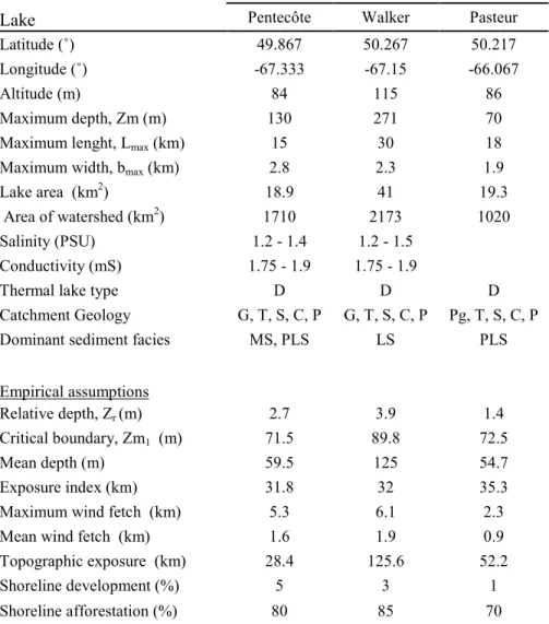
Table 1. Characteristics of the studied lakes and empirical parameters relating laminated sediments to lake morphometry
Lake Pentecôte Walker Pasteur
Latitude (˚) 49.867 50.267 50.217
Longitude (˚) -67.333 -67.15 -66.067
Altitude (m) 84 115 86
Maximum depth, Zm (m) 130 271 70
Maximum lenght, Lmax (km) 15 30 18
Maximum width, bmax (km) 2.8 2.3 1.9
Lake area (km2) 18.9 41 19.3
Area of watershed (km2) 1710 2173 1020
Salinity (PSU) 1.2 - 1.4 1.2 - 1.5
Conductivity (mS) 1.75 - 1.9 1.75 - 1.9
Thermal lake type D D D
Catchment Geology G, T, S, C, P G, T, S, C, P Pg, T, S, C, P
Dominant sediment facies MS, PLS LS PLS
Empirical assumptions
Relative depth, Zr (m) 2.7 3.9 1.4
Critical boundary, Zm1 (m) 71.5 89.8 72.5
Mean depth (m) 59.5 125 54.7
Exposure index (km) 31.8 32 35.3
Maximum wind fetch (km) 5.3 6.1 2.3
Mean wind fetch (km) 1.6 1.9 0.9
Topographic exposure (km) 28.4 125.6 52.2
Shoreline development (%) 5 3 1
Shoreline afforestation (%) 80 85 70
Basic morphometric characteristics according to (Gagnon-Poiré 2016; Normandeau et al. 2016). Thermal lake type: D - dimictic. Catchment geology: G gneiss, Pg paragniess, T morainic till, S sand and gravel, C clay and silt, P peat. Empirical assumptions (Hutchinson 1957; Larsen and MacDonald 1993; Tylmann et al. 2013; Wetzel et al. 1991). Facies legend is given in Table 2.