1 PESTEAUX: A PROJECT FOR BUILDING GIS-BASED TOOL FOR THE ASSESSMENT OF WATER POLLUTION RISKS AT LOCAL SCALE DUE TO
PESTICIDES
Boubacar Billo BAH1*, Stéphanie NOËL2*, Dominique BUFFET1, François HENRIET3,
Olivier PIGEON3, Bruno HUYGHEBAERT2
1Walloon Agricultural Research Centre (CRA-W), Biometry, Data management and Agrometeorology Unit, Gembloux, BELGIUM
2 CRA-W, Agricultural Engineering Department, Gembloux, BELGIUM 3 CRA-W, Pesticide Research Department, Gembloux, BELGIUM
* b.bah@cra.wallonie.be, noël@cra.wallonie.be Abstract
Diffuse pollution of water resources due to pesticides uses is a major environmental issue in the European Union, regulated by specific legislations: the Water Framework Directive (Directive 2000/60/EC) and the Thematic Strategy on the Sustainable Use of Pesticides. Solving this environmental problem requires methods and tools for spatial risk analysis, notably at a local scale (agricultural parcel level). This paper presents the first developments of a decision support system aiming to assess surface and ground waters pollution risks due to pesticides uses, based on a Geographic Information System (GIS). Different factors affecting pesticide environmental propagation are taken into account, as for example land use, pesticides properties and application modalities, environment characteristics (soil properties, topography, climate, …) as well as surface and ground waters characteristics. A pesticide emission model is used to assess pesticide leaching or runoff to water resources. The reference scale for risks assessment is the agricultural parcel. The quality of the results obtained will be assessed by comparison with existing water monitoring data and related studies.
Keywords: Pesticide, vulnerability, surface and ground waters pollution, risks assessment, modelling, GIS.
2 Introduction
Nowadays, pesticides pollution of drinking water reserves and aquatic systems is a key issue of the European Policy with the implementation of the Water Framework Directive (Directive 2000/60/EC) and the Thematic Strategy on the Sustainable Use of Pesticides. According to these legislations, Member States are supposed to take measures to limit environmental and toxicological effects caused by pesticides uses1.
This project initiated by the Walloon Agricultural Research Centre (CRA-W) aimed at implementing a decision support system based on a Geographic Information System (GIS) to assess diffuse (non-point sources) pollution risks of surface and ground water resources by pesticides.
Contrary to most of the existing tools usually working at a wider scale (catchment or regional level), the innovative aspect of the approach is the possibility to generate pollution risks maps at a local scale (agricultural parcel level). Another originality of the tool is the possibility to estimate pollution risks by taking into account worst-case scenarios and highlight sensitive areas.
This paper describes the methodology followed for the development of the pesticide pollution risks assessment tool.
Material and Methods
Water pollution risk assessment
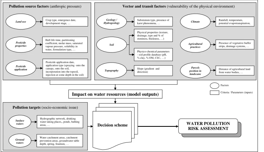
Pollution risks assessment depends on three main factors: (1) the pollution source, (2) the environment in which transits the pollutant, and which is also the vector of transmission and dispersion, and (3) the pollutant receiver(s) i.e. the surface and ground water resources in our study. Figure 1 gives a schematic overview of the main factors involved.
1 A Thematic Strategy on the Sustainable Use of Pesticides [COM(2006) 372 final]. Full details
3
v
Figure 1 – Schematic overview of the pollution risks assessment.
Parcels position in landscape Agricultural practices Climate Topography Soil Geology / Hydrogeology
Slope (gradient and direction)
Presence of vegetative buffer strips, drainage systems, … Rainfall, temperature, potential evapotranspiration, …
Physico-chemical parameters - soil profile database (pH, % clay, % OM, CEC, …) Physical properties (texture, drainage, type and % of stoniness, thickness, …) Substratum type, presence of karst phenomena, …
Vector and transit factors (vulnerability of the physical environment)
Distance of agricultural land from water bodies, …
Pesticide properties
Land use Crop type, emergence date,
development stage, …
Half-life time, partitioning coefficient, molar mass, saturated vapour pressure, solubility in water, formulation type, …
Pesticide application date, application type (spraying onto the canopy, onto the soil,
incorporation into the topsoil, injection at some depth in the soil)
Pesticide application
Pollution source factors (anthropic pressure)
Factors
Criteria / Parameters (inputs)
Decision scheme
Impact on water resources (model outputs)
WATER POLLUTION RISK ASSESSMENT Surface
waters
Hydrographic network, drinking water taking places,, ponds, bathing areas, …
Water catchment areas, catchment prevention areas, groundwater table depth, spring, fountain, …
Ground waters
4
Pollution source factors
In our study, only diffuse pollution is considered and is characterized by parameters related to land use (crop type, …), pesticide properties (particularly half-life time, partitioning coefficient, sorption coefficient, solubility in water, …) and pesticide application modalities (date, type, quantity).
Vector and transit factors
Pesticides are mainly propagated by water, through runoff to surface waters and infiltration into the soil to groundwaters. Pesticides transfer from the soil to water depends on several parameters: (i) environmental characteristics (geology and hydrogeology, soil, topography and climate), determining the vulnerability to pollutants penetration and migration; (ii) agricultural practices, such as protection means (vegetative buffer strips, …), a way to limit pesticide transfer into water, or drainage systems, which can have opposite effects by draining pesticides rapidly into surface waters; and (iii) agricultural parcels position in landscape with regard to water bodies.
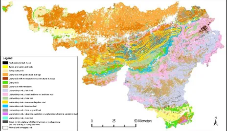
One of the core data sources of the local risks assessment is the Digital Soil Map of Wallonia (Fig. 2), implemented from the Belgian ”paper” Soil map at the scale of 1/20,000, providing detailed geomorphopedologic information at parcel level.
Figure 2 – Digital Soil Map of Wallonia (Bah et al., 2006).
5
Pollution targets
Pollution targets are, in the framework of this study, water resources (surface and ground waters). Thus, pollution risks will be assessed for both surface and groundwaters which implies to consider spatial and monitoring databases for these two water resources. For example the hydrographical network or ponds will be taken into account for surface waters and water catchments for groundwaters.
Modeling tool
Modeling is more and more used for pesticides runoff and leaching assessment and therefore to assess the risks to pollutants propagation. In our study we have selected, on the basis of a state-of-the-art, a pesticide leaching to groundwater and drainage/runoff to surface water model named GeoPEARL (Tiktak et al., 2003). GeoPEARL consists in a GIS coupled to a one-dimensional, dynamic and multi-layered model (PEARL: Pesticide Emission Assessment at Regional and Local scales) of the fate of pesticides and relevant transformation products in the soil-plant-atmosphere system. Model inputs are mainly extracted from the existing databases of pesticide properties (source) and environmental characteristics (vector/transit). Parameters not directly available in existing databases, such as bulk density, hydraulic conductivity, … will be derived from pedotransfers functions. Relevant parameters, such as karst phenomena, proximity of agricultural parcels in comparison to surface waters, … not taken into account by the model, will be considered in the decision scheme.
Validation of results
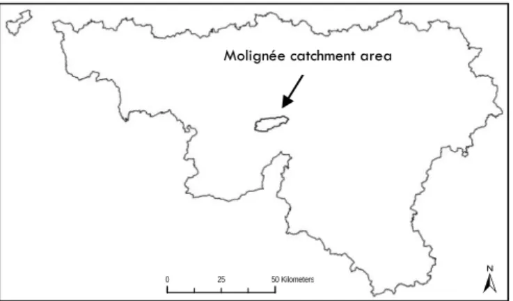
Validation will be conducted in pilot areas, where monitoring data on surface and groundwaters are available. The first selected pilot area is the Molignée catchment (Fig. 3), in the Belgian Condroz region. Molignée catchment is a geomorphopedological contrasted area. Several relevant hydrogeologic, pedologic and hydrologic studies (DGRNE, 2000) have been conducted in this area. Results of these studies will be used to validate the developed pollution risks assessment system.
6
Figure 3 – Location of the pilot area in Walloon region (Belgium).
References
Bah B., Veron P., Lejeune P., Rondeux J., Bock L. (2006). Carte des principaux types de sols de la Région wallonne. Edition à 1/250 000. D’après la Carte des sols de la Belgique à 1/20.000 de l’IRSIA et sa version numérisée. Faculté universitaire des Sciences agronomiques de Gembloux (FUSAGx). Gembloux, Belgique. Carte réalisée dans le cadre de la phase « interprétation » du Projet de Cartographie numérique des sols de Wallonie, financé par la Région wallonne (DGA).
DGRNE (2000). Bassin hydrographique de la Molignée - volume 1 - Facteurs abiotiques. Direction Générale des Ressources Naturelles et de l’Environnement. Ministère de la Région wallonne, Namur. 205p + annexes.
EC (European Communities). Directive of the European Parliament and of the Council of 23 October 2000 establishing a framework of Community action in the field of water policy (2000/60/EC), 22 December 2000. Official Journal of the European Communities 2000; L 327.
Tiktak, A., Van der Linden, A.M.A. & Boesten, J.J.T.I. (2003). The GeoPEARL model. Model description, applications and manual. RIVM (Bilthoven), Alterra (Wageningen, The Netherlands). RIVM report 716601007/2003, 79 pp.
0 25 50Kilometers
Molignée catchment area