DOCTORAT DE L'UNIVERSITÉ DE TOULOUSE
Délivré par :
Institut National Polytechnique de Toulouse (Toulouse INP) Discipline ou spécialité :
Surfaces Interfaces Continentales Hydrologie
Présentée et soutenue par :
M. CLEMENS VON SCHEFFER le mercredi 3 juillet 2019
Titre :
Unité de recherche : Ecole doctorale :
Holocene human impact, climate and environment in the northern Central
Alps: A geochemical approach on mountain peatlands
Sciences de l'Univers de l'Environnement et de l'Espace (SDU2E)
Laboratoire Ecologie Fonctionnelle et Environnement ( ECOLAB) Directeur(s) de Thèse :
M. GAËL LE ROUX M. INGMAR UNKEL
Rapporteurs :
Mme ANNE-VERONIQUE WALTER-SIMONNET, UNIVERSITE DE BOURGOGNE Mme KARIN KOINIG, UNIVERSITY OF INNSBRUCK
Membre(s) du jury :
M. RAINER DUTTMANN, CHRISTIAN ALBRECHTS UNIVERSITAT KIEL, Président M. FRANCOIS DE VLEESCHOUWER, CNRS TOULOUSE, Invité
M. GAËL LE ROUX, TOULOUSE INP, Membre
M. INGMAR UNKEL, CHRISTIAN ALBRECHTS UNIVERSITAT KIEL, Membre
Dr. Gaël Le Roux (Toulouse INP)
Prof. Dr. Ingmar Unkel (Kiel University)
Date of Disputation: 03.07.2019
Examination chairperson:
External reviewer 1:
External reviewer 2:
Place of Disputation: Kiel
--- Abstract (English)
Since the last deglaciation the European Alps have experienced several phases of human colonisation from different directions and societies. However, the interaction of climate, human impact and environment is still not fully understood in this high mountain region. In particular, information on the time and scale of human impact in the northern Central Alps (NCA) during the Holocene is missing. This study fills this gap by using geochemical, pollen and radiocarbon analyses in comparison to regional archaeological and historical data. Mires in three areas of the NCA were selected as study sites: Kleinwalser Valley (Vorarlberg, Austria), Piller Mire (Tyrol, Austria) and upper Fimba Valley (Grisons, Switzerland), situated in an altitudinal range of 1100 to 2400 m a.s.l.
These mires were cored and analysed. The use of geochemical proxies (lithogenic elements, trace metals) in peat is a well-established method to detect mineral input, erosion or metallurgical activities. Despite an advantage of a fast sample preparation and measurement, applying portable X-Ray-Fluorescence analysis (pXRF) on mountain mires is an uncommon approach, mainly due to limitations by low count rates, matrix effects or lacking calibrations for organic materials. By calibrating pXRF with measurements of quantitative Inductively Coupled Plasma – Mass Spectrometry (ICP-MS), these issues could be overcome, showing that, Ti, Pb, Sr, Zn, K, S, Fe, V, Zr, and - to some extent - Rb, Ca and Mn, can be successfully calibrated and used as palaeoenvironmental proxies in peat. These proxies allow the following conclusions:
At high elevations, periglacial processes influence the deposition processes in the mires. Around 8200 and in the late 7th millennium BP, wetter and colder climate conditions prevail in the region.
The earliest land use is recorded in the Kleinwalser Valley around 5500 cal BP, with fire clearings, pastoralism and hints at previously undetected regional metallurgy. Just before the Bronze Age (c. 4300 cal BP), centuries before mining districts in the Eastern Alps boomed, metallurgy around the Piller Mire is detected. The possibly strongest human land use in prehistoric times affects all sites from the Mid to Late Bronze Age (3500-3000 cal BP), as shown by elevated erosion and significant landscape alteration – from forests to agro-pastoral systems. Potential metal enrichments are, however, masked by high mineral inputs. This period is followed by a phase of lower land use, reaching well into the late Roman period (2800 cal BP to 250 cal CE). However, a strong Pb enrichment factor (Pb EF) in the Kleinwalser Valley is recorded around 2700 cal BP. Human impact increases in north-western Tyrol around 2400 cal BP. Periods of mining and metallurgy are indicated by increased Pb EF in all mires during the Roman Empire but also right after its collapse. Intensive human activities rise again with the fading Roman power after 250
cal CE in the Kleinwalser Valley but are interrupted by a climate deterioration after 500 cal CE (Late Antique Little Ice Age). At the sites in higher elevations, land use intensification does not take place before the High Middle Ages and is accompanied by rising Pb EF, indicating mining activities after 1000 cal CE. While Pb EF keeps rising due to mining, industrialisation and leaded fuel until 1980 cal CE, fluctuating human impact (deforestation, pasture management, drainage) can be linked to a varying impact of climatic, cultural and demographic factors. Over the last century, growing tourism and infrastructure construction increase erosion, but land use change leads to a recovery of the studied mires in Kleinwalser Valley and Tyrol.
The results of this study add a new dimension to archaeological and historical data, by showing the wider extent of human land use and its links to climate. Moreover, previously unknown periods of prehistoric mining or metallurgy in the NCA are revealed, encouraging further interdisciplinary research.
---
Abstract (Français)
Les Alpes européennes ont connu plusieurs phases de colonisation humaine. Cependant, l'interaction entre climat et impacts humains sur l'environnement dans le passé n'est pas encore totalement comprise dans cette région de haute montagne. Il existe notamment un manque de connaissances sur la chronologie et l'ampleur des impacts humains dans les Alpes centrales du nord (ACN) pendant l'Holocène, que cette étude comble en utilisant des analyses géochimiques, de palynologiques et de datation radiocarbone comparées avec des données archéologiques et historiques régionales. Des tourbières dans trois secteurs des ACN ont été choisies comme sites d'étude: Petite Vallée de Walser (PVA, Autriche), Tourbière Piller (TP, Autriche), vallée de Fimba (VF, Suisse).
La géochimie de séquences de tourbe est une méthode bien établie pour détecter les apports minéraux, l'érosion ou les activités métallurgiques. L'application de l'analyse par fluorescence des rayons X portable (pXRF) sur les tourbières de montagne reste une approche peu courante, principalement en raison des limitations dues aux limites de détection, aux effets de matrice ou à l'absence de calibration. En étalonnant la pXRF à l'aide de mesures de spectrométrie de masse à plasma à couplage inductif (ICP-MS), cette étude montre que Ti, Pb, Sr, Zn, K, S, Fe, V, Zr et, dans une certaine mesure Rb, Ca et Mn, peuvent être étalonnés dans la tourbe.
À haute altitude, les processus périglaciaires influencent les processus de dépôt dans les tourbières. Vers 8200 et 6300 cal BP, les conditions climatiques sont plus froides et humides. La
première utilisation du sol a été enregistrée dans la PVA vers 5500 cal BP, avec de la déforestation, du pastoralisme et des signes d’une métallurgie régionale jusqu’alors non-détectée. Juste avant l'âge du bronze (environ 4300 cal BP), des siècles avant l'essor des régions minières des Alpes de l'Est, la métallurgie autour la TP est donc détectée. L'utilisation des sols par l'homme, probablement la plus forte de la préhistoire, affecte tous les sites d’études à l'âge du bronze (3500-3000 cal BP), comme le montrent l'érosion élevée et la modification significative du paysage - de la forêt aux systèmes agro-pastoraux. Les facteurs d’enrichissements en métaux (Pb EF) sont toutefois masqués par des apports élevés en minéraux. Cette période est suivie d'une phase d'utilisation plus faible des sols jusqu'à l'époque romaine. Un fort Pb EF dans la PVW est cependant enregistré autour de 2700 cal BP et l'impact humain augmente autour de la TP vers 2400 cal BP. L'exploitation minière romaine est indiquée par une augmentation du Pb EF dans toutes les tourbières. Les activités humaines intensives reprennent avec le déclin de la puissance romaine après 250 cal CE dans la PVW, mais sont interrompues par une détérioration du climat après 500 cal CE. Sur les sites situés en altitude plus hauts, l'intensification de l'utilisation des sols n'a pas lieu avant le haut Moyen Âge (1000 cal CE) et s'accompagne d'une augmentation du Pb EF. Alors que le Pb EF continue d'augmenter en raison de l'exploitation minière, de l'industrialisation et des essences plombées jusqu'en 1980, les fluctuations de l'impact humain (défrichements, pâturages, drainage) peuvent être liées à des facteurs climatiques, culturels et démographiques variables. Au cours du siècle dernier, la croissance du tourisme et la construction d'infrastructures ont augmenté l'érosion, mais le changement d'occupation des sols a entraîné une régénération des tourbières étudiées.
Les résultats de cette étude ajoutent une nouvelle dimension aux données archéologiques et historiques, en montrant l'étendue plus large de l'utilisation humaine des sols et les liens avec le climat. De plus, des périodes de métallurgie préhistoriques jusque-là inconnues, dans les ACN sont révélées, ce qui encourage la poursuite des recherches interdisciplinaires associant archéologie, paléobotanique et géochimie environnementale.
---
Abstract (German)
Seit dem Ende der letzten Eiszeit haben die europäischen Alpen mehrere Phasen der menschlichen Kolonisation erlebt. Allerdings sind für diese Gebirgsregion die Wechselwirkungen von Klima, menschlichem Einfluss und Umwelt noch nicht vollständig geklärt. Insbesondere das Wissen über die Zeitpunkte und Ausmaße der menschlichen Auswirkungen in den nördlichen Zentralalpen (NZA) während des Holozäns ist noch mangelhaft. Mit Hilfe von Geochemie-,
Pollen- und Radiokohlenstoffanalysen und deren Vergleich mit regionalen archäologischen und historischen Daten soll diese Arbeit zur Ausfüllung dieser Lücken beitragen. Dazu wurden Bergmoore in drei Untersuchungsgebieten der NZA ausgewählt: Kleinwalsertal (Vorarlberg, Österreich), Piller Moor (Tirol, Österreich) und oberes Fimbatal (Graubünden, Schweiz).
Aus diesen Mooren wurden Proben entnommen und untersucht. Die Verwendung geochemischer Proxys (lithogene Elemente, Spurenmetalle) in Torfen ist dabei eine etablierte Methode zum Nachweis von Mineraleintrag, Erosion oder metallurgischen Aktivitäten. Trotz der Vorteile einer schnellen Probenvorbereitung und Messung ist der Einsatz der tragbaren Röntgenfluoreszenzanalyse (pXRF) insbesondere für Moore selten: aufgrund von Einschränkungen durch niedrige Zählraten, Matrixeffekte oder fehlende Kalibrierungen für organische Materialien. Durch die Kalibrierung der pXRF mit Messungen der quantitativen „Induktiv gekoppelten Plasma-Massenspektrometrie“ (ICP-MS) konnte dieses Problem gelöst werden. Diese Studie zeigt, dass Ti, Pb, Sr, Zn, K, S, Fe, V, Zr und - zum Teil - Rb, Ca und Mn erfolgreich kalibriert werden und als paläoökologische Proxys in Torf verwendet werden können. Diese Proxys lassen folgende Schlüsse zu:
In hohen Lagen beeinflussen periglaziale Prozesse die Depositionsprozesse in den Mooren. Um 8200 und im späten 7. Jahrtausend cal BP herrschen feuchtere und kältere Klimabedingungen im Untersuchungsgebiet. Die früheste Landnutzung ist im Kleinwalsertal um 5500 cal BP zu verzeichnen, mit Brandrodungen, Viehzucht und Hinweisen auf bisher unentdeckte regionale Metallurgie. Kurz vor der Bronzezeit (ca. 4300 cal BP), Jahrhunderte vor dem Boom der Bergbaugebiete in den Ostalpen, sind metallurgische Spuren um das Piller Moor nachweisbar. Die möglicherweise umfassendste prähistorische menschliche Landnutzung betrifft alle Standorte von der mittleren bis zur späten Bronzezeit (3500-3000 cal BP) in Form erhöhter Erosion und erheblicher Landschaftsveränderungen – von Wald- zur Weidelandschaft. Mögliche Metallanreicherungen werden jedoch durch hohe Mineralstoffeinträge überdeckt. Dieser Zeit folgt eine Phase geringerer Landnutzung, die bis weit in die römische Zeit reicht (2800 cal BP bis 250 cal CE). Im Kleinwalsertal wird jedoch um 2700 cal BP eine erhöhte Bleianreicherung sichtbar, während in Nordwesttirol eine Zunahme des menschlichen Einflusses um 2400 cal BP registriert wird. Der weit verbreitete römische Bergbau wird durch einen erhöhten Bleianreicherungsfaktor (Pb EF) in allen untersuchten Mooren angezeigt. Eine kurze Zeit regionaler Bergbauaktivitäten scheint auch unmittelbar nach dem Zusammenbruch des Römischen Reiches stattgefunden zu haben. Intensivere menschliche Aktivitäten beginnen ab ca. 250 cal CE mit dem Verfall Römischer Macht im Kleinwalsertal, werden aber durch eine Klimaverschlechterung nach 500 cal CE unterbrochen. An den höher gelegenen Standorten findet die Intensivierung der Landnutzung erst im Hochmittelalter (ca. 1000 cal CE) statt. Ein
steigender Pb EF deutet außerdem auf stärker werdende Bergbauaktivitäten hin. Während der Pb EF aufgrund von Bergbau, Industrialisierung und verbleitem Brennstoff bis 1980 cal CE weiter ansteigt, können menschliche Eingriffe in die Landschaft (Rodungen, Weidemanagement, Entwässerung) mit unterschiedlichen Auswirkungen klimatischer, kultureller und demografischer Faktoren verbunden werden. Im Laufe des letzten Jahrhunderts verstärken wachsender Tourismus- und Infrastrukturbau die Erosion, doch eine veränderte Landnutzung führte schlussendlich zu einer Erholung der untersuchten Moore im Kleinwalsertal und in Tirol.
Die Ergebnisse der vorgelegten Studie verleihen den archäologischen und historischen Daten eine neue Dimension, indem sie das Ausmaß der menschlichen Landnutzung und dessen Verbindungen zum Klima zeigen. Darüber hinaus werden bisher unbekannte Perioden des prähistorischen Bergbaus oder der Metallurgie in den NZA aufgedeckt.
Acknowledgements
First of all, I would like to thank my three supervisors for supporting me in every situation, from the beginning to the end of the three years, and for giving me time and space but also for pushing me forward when I needed it. Ingmar Unkel for encouraging me to apply for this PhD-position in the first place. François De Vleeschouwer for making possible the cotutelle and especially for hosting me during my visits in Toulouse: with good food, drinks and SP-episodes. Also, Gaël Le Roux for advice in the lab, for involving me into fieldwork in the Pyrenees and for taking over François’ position in the final phase. Particularly when hearing stories from other PhD-students, I can say that I have been really lucky and that I am very grateful to have had them as my supervisors.
During my stays at Ecolab in Toulouse, I met many very nice and kind people. Chuxian Li was not just a PhD-comrade and a helping hand for peat core slicing and in one of the field campaigns, but also became a dear friend to me. Besides being very kind, also Marie-Jo Tavella at Ecolab has always been there to help in the lab and Annick Corrège overcame any of my issues with the French bureaucracy. At Kiel University, I would like to thank Annika Lange for counting pollen, Britta Witt for managing organisational issues and paperwork, Marcus Schütz and Mathias Bahns for their support with technical issues and for rescuing a stuck corer, Alexander Suhm, Sandra Kiesow and the international Master students for joining field work in the Alps in 2016 and 2017, Joachim Schrautzer for the enthusiastic support in the Kleinwalser Valley and, of course, the proof-readers. Special thanks are also going out to Karl Keßler from the landscape conservation association of the Kleinwalser Valley for organising access to the mires, but also for a nice dinner with the best Käsknöpfle I ever had. I would also like to thank Dr. Ernst Partl of the Kaunergrat nature park in Tyrol. Besides life at universities, I would like to say thank you to my friends and family for understanding that my time has been limited lately. Finally, I do not want to forget to mention whomever I forgot to mention.
Funding
I would like to express my gratitude for several travel grants and financial support, which greatly contributed to the successful completion of this bi-national PhD-project:
- “Soutien à la Mobilité Internationale (SMI) 2016” from the Institut National Polytechnique de
Toulouse.
- PPP (Nr 57316724)/PHC-PROCOPE Nr 37646SG from DAAD/Campus-France (partly funded by the BMBF – German Federal Ministry of Education and Research).
- Mobility grant from Deutsch-Französische Hochschule/université franco-allemande (DFH/UFA).
The PhD-project was co-funded by the Graduate School “Human development in landscapes” at Kiel University (DFG-Excellence Initiative, GSC-208).
1
Inhalt
1 Introduction ... 1
1.1 Aims and key questions of this study ... 2
2 Study area and background information ... 4
2.1 Geology and geography ... 4
2.2 Climate and environment in the Central Alps ... 5
2.3 Population dynamics and human land use ... 6
2.4 Prehistoric mining and metallurgy ... 7
2.5 Peatlands: functions and implications for palaeoenvironmental-research ... 9
3 Methods ... 14
3.1 Coring techniques ... 14
3.2 Core slicing and subsampling ... 16
3.3 Radiocarbon dating ... 17
3.4 Geochemistry ... 18
3.4.1 ICP-MS and ICP-OES ... 18
3.4.2 Portable XRF scanning ... 20
3.4.3 XRF core scanning ... 26
3.4.4 Carbon/Nitrogen ratio ... 28
3.4.5 Enrichment factors and mineral accumulation rates ... 28
3.4.6 Principal Component Analysis ... 31
3.5 Core descriptions and macrofossil analysis ... 31
3.6 Pollen... 32
3.7 Terminology of chronological classification ... 32
4 Kleinwalser Valley ... 34
4.1 Introduction (Kleinwalser Valley) ... 34
4.1.1 Geographical and geological setting (Kleinwalser Valley)... 36
4.1.2 Climate (Kleinwalser Valley) ... 38
4.1.3 Coring sites description (Kleinwalser Valley) ... 38
4.1.4 Coring and subsampling (Kleinwalser Valley) ... 41
4.2 Results & discussion (Kleinwalser Valley) ... 42
4.2.1 Core descriptions (Kleinwalser Valley) ... 42
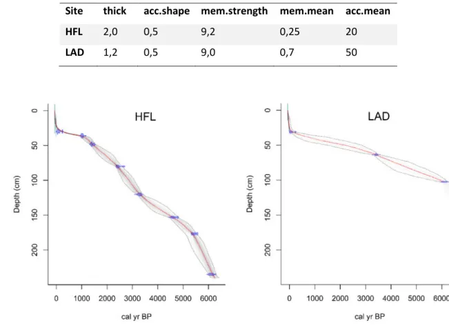
4.2.2 Radiocarbon dates and age-depth models (Kleinwalser Valley) ... 44
4.2.3 Geochemistry (Kleinwalser Valley)... 47
4.2.4 Pollen (HFL) ... 61
4.3 Chronological discussion (Kleinwalser Valley) ... 63
4.3.2 5800 to 3500 cal BP: early human occupation... 64
4.3.3 3500 cal BP to 2800 cal BP: Bronze Age ... 67
4.3.4 2800 cal BP to 600 cal CE: Iron Age and Roman period ... 68
4.3.5 600 cal CE to 2016 CE: from Early Middle Ages to Modern Times ... 71
4.4 Conclusions on the Kleinwalser Valley ... 75
5 Piller Mire ... 77
5.1 Introduction (Piller Mire) ... 77
5.1.1 Geographical and geological setting (Piller Mire) ... 79
5.1.2 Climate (Piller Mire) ... 80
5.1.3 Coring site description (Piller Mire) ... 80
5.1.4 Coring and subsampling (Piller Mire) ... 82
5.2 Results & discussion (Piller Mire) ... 83
5.2.1 Core description (Pi17, Piller Mire) ... 83
5.2.2 Radiocarbon dates and age-depth models (Piller Mire) ... 84
5.2.3 Geochemistry (Piller Mire) ... 86
5.3 Chronological discussion (Piller Mire) ... 94
5.3.1 4800 to 4000 cal BP: transition to the Bronze Age ... 95
5.3.2 3900 to 2800 cal BP: Bronze Age ... 97
5.3.3 2800 to 1950 cal BP: Iron Age to Roman Expansion ... 99
5.3.4 1950 cal BP to 700 cal CE: Roman period and Early Middle Ages ... 100
5.3.5 700 cal CE to 2017 cal CE: Middle Ages and Modern Era ... 102
5.4 Conclusions on the Piller Mire ... 106
6 Fimba Valley ... 108
6.1 Introduction (Fimba Valley) ... 108
6.1.1 Geographical and geological setting (Fimba Valley) ... 109
6.1.2 Climate, vegetation and recent land use (Fimba Valley) ... 110
6.1.3 Coring site descriptions (Fimba Valley) ... 111
6.1.4 Coring and subsampling (Fimba Valley) ... 113
6.2 Results & discussion (Fimba Valley) ... 114
6.2.1 Core descriptions (Fimba Valley) ... 114
6.2.2 Radiocarbon dates and age-depth models (Fimba Valley) ... 117
6.2.3 Geochemistry (Fimba Valley) ... 121
6.3 Chronological discussion (Fimba Valley) ... 128
6.3.1 Early to Mid-Holocene (10,500 to 6300 cal BP) ... 129
6.3.2 6200 to 2800 cal BP ... 132
6.3.4 450 cal CE until Modern Times ... 138
6.4 Conclusions on the Fimba Valley ... 141
7 Synthesis ... 144
7.1 Regression analysis comprising all samples ... 144
7.2 Integrated chronological discussion ... 148
7.2.1 Early to Mid-Holocene: climate versus human impact ... 149
7.2.2 4200 to 2000 cal BP: rise of human land use /land-management ... 151
7.2.3 Roman period ... 153
7.2.4 Middle Ages and Modern Times ... 155
7.2.5 Human impact and peat accumulation ... 158
8 Conclusions and perspectives ... 160
8.1 Analytical development of pXRF ... 160
8.2 Site specific factors and proxy sensitivity ... 161
8.3 Multiproxy – multisite – multi disciplinary: the key to understanding a complex changing mountain environment... 162
9 References ... 165
List of figures
Figure 1: Overview of the northern Central Alps with study sites and ore deposits ... 5
Figure 2: Subsampling sketch of Wardenaar, Usinger and Russian system... 17
Figure 3: pXRF with connected sampling chamber ... 21
Figure 4: Regression analysis of CRMs vs pXRF measurements ... 25
Figure 5: Map of the Kleinwalser Valley and surrounding areas with important sites ... 37
Figure 6: Photo of Hoefle Mire ... 39
Figure 7: Surface vegetation and boreholes of HFL and LAD ... 39
Figure 8: Photo of HHA, showing the stream meandering through the mire... 40
Figure 9: Open profile of HHA and charred wood radiocarbon sample ... 41
Figure 10: Eriophorum vaginatum spindles and Sphagnum leaf for dating ... 45
Figure 11: Age-depth models of HFL and LAD ... 46
Figure 12: Regression analysis in HFL peat samples ... 49
Figure 13: Concentration profiles of HFL peat samples ... 53
Figure 14: HFL depth-profiles for Nd/Ti in HFL and for Pb and Zn in parallel core ... 55
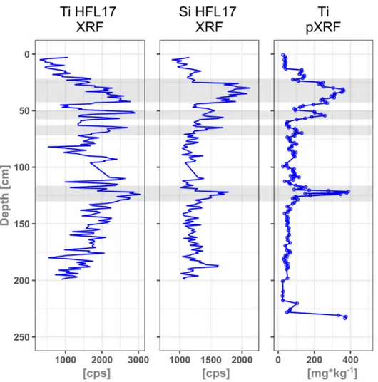
Figure 15: Ti-Profile (pXRF) in HFL compared with Ti and Si (XRF) in a parallel core ... 56
Figure 16: Elemental concentration profiles of calibrated pXRF in LAD ... 58
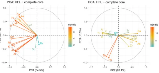
Figure 17: PCA of the ICP-MS results of the complete core of HFL ... 59
Figure 18: PCA of ICP-MS measurements in ombrotrophic section of HFL ... 60
Figure 19: Profiles of C:N and S in HFL ... 61
Figure 20: Pollen diagram of HFL Mire ... 62
Figure 21: Chronological profiles of Sr, C:N and Pb EF in HFL, MAR in HFL and LAD and pollen groups in HFL ... 65
Figure 22: Enrichment factors in HFL of Pb, Cu, Zn and Sb ... 66
Figure 23: Map of region around the Piller Mire with relevant ore deposits/ancient mines ... 77
Figure 24: Detailed aerial photo of Piller Mire and surroundings ... 79
Figure 25: Photo of Piller Mire borehole with surface vegetation ... 81
Figure 26: Photo with view on the open Piller Mire ... 82
Figure 27: Photo of Sphagnum stem with leaves in Pi17 sent for dating ... 85
Figure 28: Age-depth model of Pi17 ... 85
Figure 29: Regression analysis of ICP-MS and pXRF measurements in Pi17-sequence ... 87
Figure 30: Elemesntal profiles in the Pi17 composite core ... 90
Figure 31: Core scanning profiles of Pb, Ti and Si of Pi17 ... 92
Figure 32: PCA of ICP-MS measurements in the Pi17 core ... 93
Figure 34: Chronological profiles of MAR, EF Pb, EF Zn, EF Cu and EF Sb in Pi17 ... 97
Figure 35: Aerial photo from 1974 CE of Piller Mire and peat mining facility ... 104
Figure 36: Full profile of Pb EF in the Piller Mire ... 105
Figure 37: Overview map of Fimba Valley and surroundings ... 109
Figure 38: Photo of Upper and Lower Las Gondas (ULG and LLG) ... 111
Figure 39: Satellite image of the upper Fimba Valley with cored sites ... 112
Figure 40: Photo of western side of Fimba Valley ... 113
Figure 41: BWM core line scan ... 116
Figure 42: Heterogeneous LCM core, alternating peat and sediment layers ... 117
Figure 43: Brown moss from LLG sent for dating ... 118
Figure 44: Age-depth model of LLG-A ... 119
Figure 45: Age-depth-model of MM-A ... 120
Figure 46: Age-depth model of BWM ... 120
Figure 47: Age-depth model of ULG... 121
Figure 48: Regression analyses in LLG ... 122
Figure 49: Elemental profiles in LLG derived from ICP-MS and pXRF ... 125
Figure 51: XRF core scanning profiles of Si and Pb in the MM core ... 126
Figure 52: PCA of ICP-MS measurements in LLG ... 128
Figure 53: Coarse sediment layer of the 8.2 ka event in LLG ... 130
Figure 54: MAR, Pb EF, Zn EF, Cu EF, and Sb EF in LLG ... 134
Figure 55: Si, Pb/Si, Cu/Si and Zn/Si profiles in the MM-core-scan ... 136
Figure 56: Cattle grazing paths on the slopes of the upper Fimba Valley ... 139
Figure 57: Combined regression analyses of HFL, Pi17 and LLG ... 145
Figure 58: Summary of mineral accumulation, Si and Pb enrichment... 154
Figure 59: Pb EF since the Late Middle Ages in all mires ... 157
Figure 60: Peat accumulation and growth rates in the investigated mires ... 159
Suppl. Figure 1: Line-scans of Kleinwalser Valley core-sequences ... 197
Suppl. Figure 2: Line-scans of a composite Piller Mire core-sequence ... 198
List of tables
Table 1: Summary of all coring sites, coordinates and analyses carried out ... 14
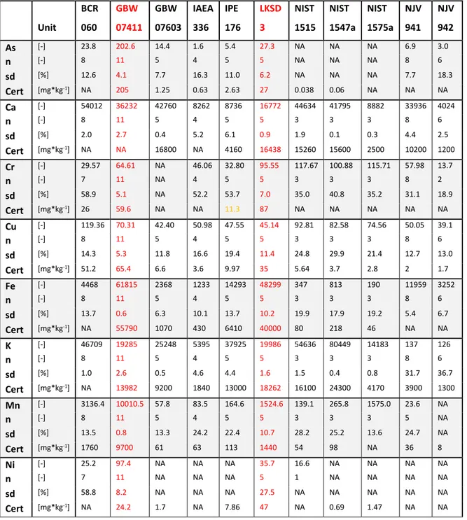
Table 2: Quality control of pXRF measurements of CRMs ... 22
Table 3: UCC values of relevant elements ... 29
Table 4: Chronological classification of cultural periods... 33
Table 5: Core description of the composite HFL peat sequence ... 42
Table 6: Core description of the composite LAD sequence ... 43
Table 7: List of Kleinwalser Valley radiocarbon samples ... 44
Table 8: Settings in rbacon for the age-depth models of HFL and LAD ... 46
Table 9: List of Piller Mire radiocarbon samples ... 84
Table 10: Settings in rbacon for age-depth model of Pi17 ... 84
Table 11: Core description of LLG ... 114
Table 12: Core description of MM ... 116
Table 13: Core description of BWM ... 116
Table 14: List of Fimba Valley radiocarbon samples ... 117
Table 15: Settings in rbacon for LLG, MM and BWM ... 119
List of abbreviations
a.s.l.: ... Above sea level (B)CE: ... (Before) Common Era BP: ... Before Present BWM: ... Butterwiesen Mire cal: ... Calibrated Cert.: ... Certified C:N: ... Carbon:Nitrogen Ratio CRM: ... Certified Reference Materials DACP: ... Dark Ages Cold Period EF: ... Enrichment factor HFL: ... Hoefle Mire ICP-MS: ... Inductively Coupled Plasma – Mass Spectrometry ICP-OES: ... Inductively Coupled Plasma – Optical Emission Spectrometry LAD: ... Ladstatt Mire LALIA: ... Late Antique Little Ice Age LIA: ... Little Ice Age LLG: ...Lower Las Gondas Mire LOD: ... Limit of Detection MAR: ... Mineral accumulation rate MM: ... Marmot Mire Pi17: ...Piller Mire core n: ... Number of measurements pXRF: ... Portable XRF REE: ... Rare earth element sd: ... Standard Deviation UCC: ... Upper continental crust ULG: ... Upper Las Gondas Mire XRF: ... X-Ray-Fluorescence analysis
1
Introduction
When the ice caps of the last glacial maximum disappeared, vegetation and game were returning. Humans began to repopulate and use a landscape that had previously been barren or inaccessible for thousands of years. Still today, high mountain areas like the Central Alps are harsh environments with extreme conditions for life. The onset of human activity on high Alpine passes, slopes, and valleys for travelling, trade, hunting (Leitner, 2015), agriculture, seasonal pastoralism (Oeggl, 2015) and dairy production (Reitmaier et al., 2018), or mining and metallurgy (e.g. Stöllner and Oeggl, 2015) is not yet fully understood. The impact radii of humans were limited by sensitive climate feedbacks and the heterogeneous landscape’s morphology. Hence, periods of colonisation or occupation climaxes did not happen contemporaneously and originated from different regions and cultures (e.g. Carcaillet, 1998; Gulisano, 1995; Kutschera et al., 2014; Oeggl and Nicolussi, 2009; Reitmaier, 2012; Vorren et al., 1993). The regional climate conditions led to a half nomadic lifestyle or transhumance, which was and still is the basis for seasonal livestock management systems in the European Alps (Reitmaier, 2017; Reitmaier et al., 2018). Archaeological evidence for this ephemeral presence is, however, difficult to detect and one of the reasons why there is no consistent narrative for the European Alps so far. Moreover, strong erosive forces of ice and water are responsible for a general scarcity of suitable palaeoenvironmental archives and archaeological sites in high mountain areas. Single archaeological finds and historical documentation cannot provide continuous information and may bias interpretations towards separate findings. Any approach to reconstruct the history of land use has to be put together piece by piece, region by region and valley by valley from lowland to summit. In particular, the complex relationships between humans and the development of environmental and climatic conditions on local or regional scales still need detailed investigation. Gaps need to be closed by research on various continuous palaeoenvironmental archives, such as lakes, glaciers or mires.
Climate, environment and human impact in the Central Alps are variables in a complex system that can interact in intricate ways. Reconstructing their past and recent development is important to better understand such systems, also to prepare for future changes concerning disaster management, infrastructure, agriculture, forestry etc. Thus, getting a better understanding requires some background knowledge on the involved factors (the Alps, area, climate, land use) as well as on the archives (peat) and tools (methods) that are available to gather information about the past. Hence, they will be introduced in the following chapter after defining the main research questions of this work.
1.1
Aims and key questions of this study
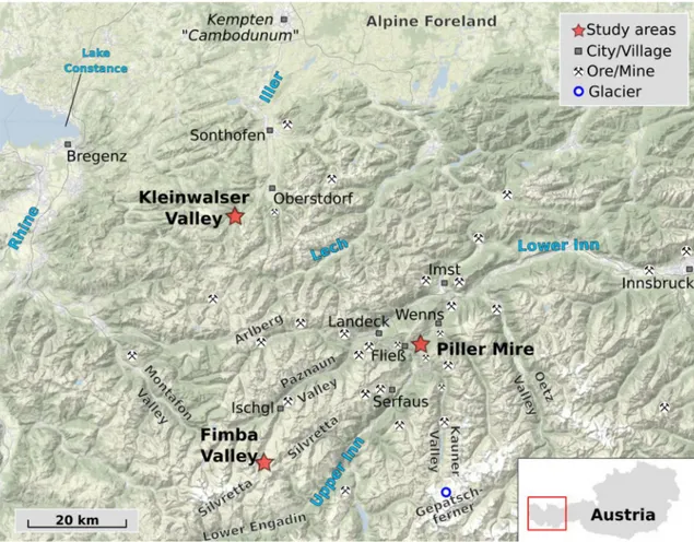
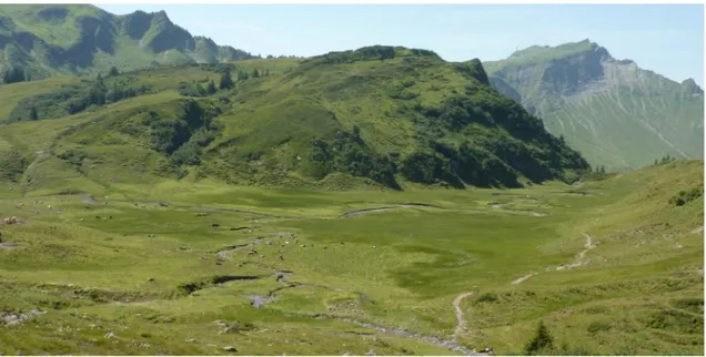
Mires in the Central Alps are hardly used as a palaeoenvironmental archive when it comes to the application of geochemical methods. Compared to lowland mires, mountain peatlands are more heterogeneous and complex systems. They are dependent on geology, geomorphology, altitude, exposition and climate, all of which are controlling hydrology, trophic state, evapotranspiration and thus vegetation, peat growth and accumulation rates. Exploiting peat sediment cores from mountain mires as palaeoenvironmental archives therefore needs to consider many possible factors. As detailed geochemical studies have not been conducted so far on any mires in the region, it is yet unknown how human or climatic impact would be reflected in the samples. One of the aims of this work is, therefore, the detection of potential geochemical signals in peat cores that can be used as proxies for erosion, mining, metallurgy or environmental feedback. They can, thus, shed light on the interactions of climate, environment and human impact on a local and regional scale in heterogeneous, elevated landscapes like the Alps. To address this heterogeneity, this approach is applied on three different study areas at different elevations in the northern Central Alps (Figure 1): the Kleinwalser Valley (Vorarlberg, Austria – chapter 4), the Piller Mire (Tyrol, Austria – chapter 5) and the upper Fimba Valley (Canton of Grisons, Switzerland – chapter 6).
The Kleinwalser Valley is both rural and touristic and a geographical gateway to the northern Alpine Foreland. By the presence of farms, roads and villages in the centre of the valley and by centuries of human activities, prehistoric traces were possibly overprinted. However, a few archaeological sites on the slopes outlived these transformations. The Piller Mire and the Fimba Valley are both located deeper within the Central Alps and further away from farms and settlements, however, prehistoric sites of particular importance exist there as well. Nonetheless, the histories of all the presented study areas are quite reduced to the last few centuries and little is known about the extent of human impact on the landscape before the Late Middle Ages: a research gap that this study is aiming to fill. It also aims at finding out if and how past human activity was recorded in local mires. Since and until when have humans been present and is there more information than archaeology and pollen could provide? What was the magnitude of their impact on environment and landscape, how was it triggered and what was the role of climate?
These research questions are related, but different when it comes to the local characteristics of the individual areas and sites and what is known about them already. One of the overarching main criteria for the selection of the studied mire sites was their vicinity to either existing archaeological sites or the availability of other complementing data. The three sites cover different levels of altitude to capture effects that could be dependent on elevation. Investigating
these spatially separated areas within a wider region allows, to some extent, to differentiate which of the recorded signals are local and independent of each other, and which could be linked by regional developments (e.g. climate) and impacts of e.g. population peaks. Furthermore, the proximity to former ore mines (Figure 1) helps to resolve questions on the existence of prehistoric mining or metallurgy in the region.
One of the basic requirements to be able to answer these questions is an efficient and reliable method to analyse the geochemistry in peat samples. Therefore, the rarely used application of a portable X-ray fluorescence (pXRF) on peat samples is critically assessed within this study. The semi-quantitative pXRF results are calibrated element by element using certified reference materials (CRM) and peat samples from the study areas, which are measured parallelly by Inductively Coupled Plasma Mass Spectrometry or Optical Emission Spectrometry (ICP-MS/OES). This approach allows listing elements that are quantifiable in peat by pXRF and evaluating where the limitations of pXRF are within this study. Further analyses include direct XRF-core-scanning, Carbon (C) and Nitrogen (N) analyses as well as pollen analysis. A chronological framework is provided by Bayesian age-depth modelling of radiocarbon dates. This enables careful interpretation of the acquired data and comparison to other studies from connected disciplines like climatology, archaeology, palynology, dendrochronology and historical sources. Is the data from the mires, for example the geochemistry, showing signals contemporaneous with archaeological findings or pollen? What was behind these signals: human activities or climate? Ultimately, the results assess the significance of the geochemical data in these mountain mires and their potential use as palaeoenvironmental proxies to eventually draw conclusions about the development of climate, human impact and environmental conditions in these three study areas of the northern Central Alps.
2
Study area and background information
2.1
Geology and geography
The Alps are the highest and largest mountain range in Europe in terms of elevation, going up to 4800 m a.s.l., but also in terms of area, covering almost 191,000 km². Along the approximately 1000 km long alpine main ridge, they are often subdivided into Western and Eastern Alps. They are shared at least partly between eight countries: Austria, France, Germany, Italy, Liechtenstein, Monaco, Slovenia and Switzerland. The focus of this study is on the northern Central Alps, the area amidst the eastern and western part, from the Alpine Rhine Valley to the Zugspitze peak, until the Alpine Divide in the south, i.e. the main Alpine Ridge. All precipitation and meltwater are collected within four different watersheds and end up in either the Rhine (Northwest), Danube (Northeast), Rhône (Southwest) or Po (South).
In terms of geology, the orogenesis of the mountain range started at the end of the Cretaceous, due to the colliding plates of the African and European continent, although the main phase of uplift occurred around 30 million years ago. As a result of the complex collision tectonics, the geology of the Alps is very complex. The main geological units are the Helvetic, Penninic, Eastern and Southern Alpine Nappes (Fitzsimons and Veit, 2001). Going from north to south in the central part of the Alps, the Helvetic Nappes (Mesozoic to Tertiary sedimentary rock) are followed by Penninic Flysch, and then by the Eastern Alpine or Austroalpine Nappes (Geological Survey of Austria, 2013). The latter are divided into the prominent Northern Limestone Alps and, to the south of it, the Eastern Alpine Crystalline, consisting of metamorphic rock like Schist and Gneiss (Egger et al., 1999). Recurring large glaciations over the Quaternary period strongly shaped the Alps into their modern form (Fitzsimons and Veit, 2001).
The three study areas (Figure 1) are distributed over three consecutive altitudinal zones:
1. Kleinwalser Valley (Austria, 1200-1000 m a.s.l.) in the montane zone 2. Piller Mire (Austria, 1550 m a.s.l.) in the subalpine zone
3. upper Fimba Valley (Switzerland, 2400 m a.s.l.) in the alpine zone
They are all north of the Alpine main ridge, which is one of the few common features. The Kleinwalser Valley is the northernmost site and shares parts of the Northern Calcareous Alps (or Northern Limestone Alps), which belong to the Upper Eastern Alpine zone, but also to the Helveticum and to subzones of the Penninic Nappes. The Piller Mire is the easternmost site and separated from the limestone by the Inn Valley and already in the metamorphic eastern alpine crystalline zone. Also, the Fimba Valley, being the southernmost site, is within this zone, although the area around it belongs to the Penninic Nappes of the Engadine Window (Geological
Survey of Austria, 2013). A more detailed description of each study area and site is provided in each of the respective sub-chapters.
Figure 1: Overview of the northern Central Alps with study sites and documented ore deposits or ancient mines compiled from (Grutsch and Martinek, 2012; Vavtar, 1988; von Klebelsberg, 1939; von Srbik, 1929; Weber, 1997).
Edited from source: Stamen Design under CC-BY-3.0 and OpenStreetMap contributors under ODbl.
2.2
Climate and environment in the Central Alps
The climate of the Alps is part of a complex system. Due to its heterogeneous topography and landscape, it can vary significantly on relatively small spatial scales. The differences are mainly the result of vertical and horizontal factors. Latitudinally and longitudinally, the Alps overlap with three climate zones. Two zones are within oceanic influence, the Atlantic in the North-western and the Mediterranean in the Southern Alps, whereas an increasing continental influence dominates the Eastern Alps. Furthermore, the Alps are right between the Icelandic Low and the Azores High and, therefore, influenced by the NAO, i.e. Northern Atlantic Oscillation (Beniston, 2005; Casty et al., 2005). One aspect of the horizontal climate pattern is expressed in the annual precipitation, which has two decreasing main gradients: from west to east and from the fringes to the inner Alpine valleys (e.g. Frei and Schär, 1998). Taking Austria as an example, the north-western regions can receive up to 4000 mm of precipitation, whereas years with less
than 700 mm are not unusual in parts of Eastern Austria (Frei and Schmidli, 2006). Moist air masses from the Atlantic and Mediterranean, are the main factor behind this distribution, as they precipitate after rising and cooling down at the slopes. Especially in the Northern and Central Alps, the highest precipitation occurs during summer (Frei and Schär, 1998).
Moving on from the spatial perspective, climate is strongly bound to altitude or elevation as well as exposure, which can be depicted with the Geiger-Köppen classification (Geiger, 1961). Based on this classification, Rubel et al. (2017) describe the modern climate zonation of the Alps with an alpine tundra climate prevailing above, and cool boreal climate below the theoretical (natural) timber line (10°C isotherm). An alpine frost or polar climate prevails only in the highest parts above the lower limit of the snow line (0°C isotherm).
However, these climate zones are not static. The current status is just a snapshot in time: The conditions will change in the future within decades and did so in the past (Rubel et al., 2017). Since the all-encompassing ice at the last glacial maximum melted away at the end of the Pleistocene, forests began to occupy the slopes and valleys, with a varying upper limit due to natural climate oscillation (e.g. Nicolussi, 2012; Nicolussi et al., 2005). Modern day’s climate change will further change the environment, especially at higher elevations (Grabherr et al., 2010) and in interaction with human land use practices (Theurillat and Guisan, 2001).
2.3
Population dynamics and human land use
Only vague estimates can be made about the population in the Alps during prehistoric times. Supposing that most early communities were probably not bound to settlements and lived as hunters and gatherers or nomads, people might have travelled between high slopes and the lower Alpine Foreland in summer and winter. Estimated numbers for Switzerland of McEvedy and Jones (1978) were 30,000 by 5500 cal BP and a four times higher population by the Late Bronze Age around 3000 cal BP, which doubled again by 2000 cal BP. In Austria, their estimates show a steeper development since 5500 cal BP from 20,000 people to already half a million by 2000 cal BP. A severe decline was documented in both areas during the Early and Late Middle Ages. Austria lost almost 38 % of its population between 1300 and 1400 AD as a consequence of the Black Death. Around 1900 AD, both countries together counted approximately 11 Million inhabitants. By the year 2007, 14 Million people lived in the area of the Alps (Alpine-Convention, 2010), mainly in the lower areas and in touristic hot spots. Except for the south-eastern Slovenian part and the south-western part of Italy, the overall population increased over the last decades (Alpine-Convention, 2010). However, Bätzing et al. (1996) reported that, from 1870 to
1990, only lower-lying valleys attracted population and grew while an adverse trend was observed for higher elevated areas.
With increasing population, the use of land became an important factor in the development of the Alps. Under the term “land use” an endless list of human activities and their consequences concerning ecosystems worldwide was summarised by DeFries et al. (2004) and Foley et al. (2005). Basic needs for food, fibre, water and shelter need to be satisfied and consume space for crops, pasture, plantations, settlements. Concerning infrastructure, streets and railways for trade and transportation, dams and pipelines for water as well as power lines for electricity are necessary. Furthermore, all resources that are required to build and sustain the system need to be harvested or mined from natural sources and deposits: wood, coal, oil, metals, stone, salt, fertilisers, food (fish and game). It is undisputed that these human requirements threaten ecosystems worldwide and, as pointed out by Foley et al. (2005), even endanger the earth’s capacity of sustaining fundamental ecosystem services (Costanza et al., 1997). With the development of mass tourism, a new factor of land use heavily affects the environment (Shaw and Williams, 1994).
In the fragile landscape of the Alps, these types of land use and their consequences on nature can be observed. It can be seen everywhere that their impact does not stop at higher elevations. Nowadays, tourism is the most important economic pillar in otherwise weakly developed regions and the impact of mass tourism replaces ‘traditional’ alpine economy and landscapes (Barker, 1982). The economic transformation from pasture, animal husbandry and forestry, to industry all the way to tourism was rapid (Lichtenberger, 1965). It led to a decline of animal husbandry and reduced the number of mountain farms (in Austria partly by a decrease of 70 % between 1970 and 1999) after they had flourished during High Middle Ages (Bender, 2010). The types, distributions and intensities of land use are, of course, strongly associated to a population’s size and change with its individual culture, economy and technology. These anthropogenic activities are affecting the landscape and, thereby, vegetation cover and sediment fluxes and patterns.
2.4
Prehistoric mining and metallurgy
A special type of land use is open mining. The chronicle of prehistoric to historic mining is long and very complex as there are several factors which are complicating any attempts of reconstructing a continuous development. Until today, metals have gained more and more importance. Most ancient mining sites were probably destroyed by the demand of land of following generations and cultures, exploiting the same ores at the same spots. Pits or other
open sites are also prone to natural erosion, especially in the mountains, where processing structures like ovens or slags are destroyed and carried away easily by natural forces. In addition, metal artefacts found in an archaeological context may have been traded or re-casted and do not have to be related to in-situ smelting or mining. Only with the invention and acceptance of Pb-isotopic studies, these issues could be tackled (O’Brien, 2015).
Some very early indications for, partly even subterranean, mining activities date back as far as the Middle Palaeolithic or the Late Pleistocene at different spots in the world: in Australia (Bednarik, 1992), in South-Africa around 45,000 years ago (Dart, 1971) and in Egypt at least 50-60,000 years ago (Vermeersch and Paulissen, 1993). Most people think of gold, silver or other metals when hearing of mining. However, these early traces were related to chert or flint deposits, exploited to produce tools and weapons. In Europe, Meso- to Neolithic flint mines were reported for the Alps by Leitner et al. (2011). Besides flint and metal, the range of extractable resources also comprises coal, peat, clay, salt and any kinds of rock.
Metallic ores were used a long time before smelting technologies were discovered, but again differently than most people would think. Goethite (FeO(OH)) and Haematite (Fe2O3), forms of
iron (hydr-)oxides, were exploited as pigments (ochre) on the African continent as early as 200,000 years ago (Barham, 2002). First hints at the existence of smelting technology as early as 7450 cal BP were suggested for lead objects in ancient Egypt. In the eastern Mediterranean, a metal hoard was dated to 5150 cal BP (Zwicker, 1989), slags in Israel at 5450 cal BP and copper artefacts on Cyprus at the same time. For the period from 4640 to 4130 cal BP, Véron et al. (2006) showed an immense Pb- pollution in bay sediments of ancient Alexandria.
One of the earliest direct evidence of copper smelting in Europe (Eastern Serbia) dates back to 7000 cal BP (Radivojević et al., 2010). The first copper objects spread from the Balkans through Central Europe in the 7th millennium BP as suggested by Höppner et al. (2005). In north Tyrol,
near Brixlegg, a copper slag was dated back to a period between 6450-5590 cal BP by Bartelheim et al. (2002) but could not be connected to any local mining or deposits. The same applies to the lake-dwelling northern Alpine Pfyn- and Mondsee cultures, who produced copper tools in the 6th millennium BP (Höppner et al., 2005).
A continuous flow of new discoveries keeps the debate open, how the technology spread from the Eastern Mediterranean to Western and Central Europe or if it developed independently. As summarised by a review on prehistoric copper mining in Europe (O’Brien, 2015), copper metal was found in Italy as early as 6300 cal BP. Metalworking and mining activities started almost simultaneously around 5500 cal BP and were an established technology by 5250 cal BP in the region of modern Italy, but it might have taken almost 1000 years more to reach the Iberian
Peninsula via Southern France. However, this was lately challenged by a study by Martínez Cortizas et al. (2016), suggesting early metallurgy around 5000 cal BP in Northern Spain. The use of copper and the technology to mine and produce it could have spread from Southern France and the Pyrenées over Atlantic France into Ireland, where arsenical copper was produced between 2350-1850 cal BP, as hypothesised by O’Brien (2015). In Great Britain, Mighall et al. (2009) found early hints for local metallurgy in Wales in the early 4th millennium BP, however,
widespread copper mining across the island was replaced by bronze metallurgy after 4150 cal BP.
Returning to the Alps, particularly the Eastern Alps (Austria) became a very important prehistoric district for copper extraction in Central Europe (Stöllner and Oeggl, 2015). First, it was mainly produced from fahlores (Cu-sulphides, often associated with As, Zn, Fe and Sb) in the Bronze Age (Goldenberg, 2015; Viehweider et al., 2013). Later, a purer type was produced from chalcopyrite (CuFeS2), followed by an intensification of extraction from around 3500-3280 cal
BP until 2750 cal BP (O’Brien, 2015; Stöllner, 2015a). The Bronze Age was a period of generally widespread metallurgic activities, not only across the Alps but also in adjacent areas, like South-West Germany (Krause, 1987). Metallurgy probably never ceased completely since then, and also salt became an important trade good and was mined by Celtic groups (Ebner et al., 1999).
Krause (1987) showed clusters of known exploited copper deposits and Early Bronze Age settlements in the Northern Alps. However, an almost empty spot was left right between the Eastern and Western Alps and this gap is still not closed (Stöllner, 2015b), despite a few indications. Also, considerable polymetallic ore resources, including Pb, exist in the northern Central Alps, of which some were being mined at least since the Late Middle Ages and partly until the 20th century AD (Grutsch and Martinek, 2012; Hammer, 1915a; Hanneberg et al., 2009a;
Neuhauser, 2015; Vavtar, 1988; Weber et al., 1997). However, clear evidence or indications for a prehistoric use of these ores are missing so far.
2.5
Peatlands: functions and implications for
palaeoenvironmental-research
Peatlands cover approximately 3 % of the earth’s landmass (Kivinen and Pakarinen, 1981). They are concentrated in temperate to cold regions of the Northern Hemisphere (North-America, Russia, Scandinavia), but also exist in (sub)tropical regions like South-East Asia (Limpens et al., 2008), Africa (Dargie et al., 2017), and at high latitudes or in mountain chains of the Southern Hemisphere (Cooper et al., 2010; Yu et al., 2010).
Besides serving as a supply for combustible material since at least 2000 years (Succow, 2012) or as an additive for agri- and horticulture, peatlands have rather been a nuisance to humanity and were drained over centuries, to gain new land for agriculture, pasture, settlements and other construction work. But over the last century, scientific efforts and discoveries have put peatlands into proper light and highlighted benefits and important ecological functions (Maltby and Proctor, 1996; Sjörs, 1980). Not only are wetlands and mires acting as a natural buffer for the hydrological balance of a region and sustaining unique ecosystems, peat can also retain and buffer or reduce the availability of anthropogenic pollutants like trace metals (Brown et al., 2000; Chaney and Hundemann, 1979; Couillard, 1994) or an excess of nutrients (Johnston, 1991; Kadlec, 1997). As climate change became part of scientific and public discourse, the role of peat as the most important terrestrial carbon storage, despite its tiny fraction of earth surface cover, became clear (Bragg and Lindsay, 2003; Page and Baird, 2016). However, human activities are still threatening wet- and peatlands by peat mining, groundwater extraction, drainage and cultivation for agricultural use. Pollution, droughts, induced fires, invasive species and eutrophication are raising the pressure put on these vulnerable ecosystems and their functions (Bragg and Lindsay, 2003; Brinson and Malvárez, 2002). For example, changing conditions like a decrease of the water table or higher temperatures can induce the release of CO2 and dissolved
organic carbon (Dise, 2009; Freeman et al., 2001) or the mobilisation of potentially toxic trace metals like As (Rothwell et al., 2009). Furthermore, the burning of tropical peatlands was held responsible for the highest rise in atmospheric CO2 concentrations since the beginning of
measurements (Page et al., 2002). The emissions of degrading peatland soils below expanding palm oil plantations are going to contribute steadily in the near future (Carlson et al., 2013).
To avoid any confusion in terminology, it is important to distinguish between peatlands, mires, peat bogs and fens. While a mire is a wet peatland that still accumulates peat, a (raised) peat bog is a special type of mire, which is – unlike a fen – very low in nutrients, acidic and only fed by atmospheric input. A fen receives nutrients from the mineral base and/or is constantly supplied with enriched surface or groundwater (Bragg and Lindsay, 2003; Dierßen and Dierßen, 2008). What all mires have in common is a mechanism that prevents or strongly limits the mineralisation and humification of organic material. As long as the combination of the overall decomposition process and compaction of buried material is slower than the biomass production in the living layers (acrotelm), a mire is still growing because peat can accumulate. The most important limiting mechanism on decomposition is the supply of oxygen. The replenishment of O2 in the water-saturated lower part of the peat column (catotelm) is very
slow. Furthermore, this tiny amount of oxygen is used up rapidly by the high abundance of decaying organic matter. Over time, most mires develop through different stages and rely on
certain conditions, like a constant supply of water or humidity, which often involves a sufficient amount of precipitation. Depending on the right conditions, e.g. water table and the water chemistry (nutrient supply), the resulting type of vegetation partly controls the accumulation of peat. The most important peat building species are mosses, which continuously grow on top of their dead stems, whereas higher plants that grow within such an environment (e.g. Carex) contribute mainly roots, since their superficial biomass decomposes before burial. Päivänen and Vasander (1994) demonstrated that only 2-16 % of the organic material produced is preserved by being buried in the catotelm.
At some point, fen type mires are theoretically making the transition from a minerotrophic fen over oligotrophic to an ombrotrophic mire (bog). While the lower part was and still is influenced by the basal sediment, the upper part has grown above the groundwater level and is out of influence of dissolved nutrient supply from deeper layers. The term ‘raised mire’ implies that it is elevated relatively to the surrounding area, often described as a convex surface form, while an exemplary fen’s surface is concave. Hence, the convex bog incorporates only atmospheric inputs and, to some extent, takes up (i.e. recycles) nutrients from decomposing material. While minerotrophic fens range between 5 to 15 % of mineral matter (Shotyk, 1988), Tolonen (1984) characterised ombrotrophic peat with an ash content around or rather below 5 %.
The earliest stage of a mire typically begins in a morphological depression or lake (pond, pool, etc.), which is continuously filled by a mix of sediment and ingrowing and dying plant material until the water level is reached and the vegetation can cover and overgrow it. In another example setting, peat can start growing directly on an impermeable substrate, e.g. clay or even bare rock, but only if a constant supply of water is available for instance, a close-by stream, a slope water runoff, precipitation etc. In this setting, a growing body of mosses builds up a sponge-like structure, which can buffer shortages in humidity by collecting and storing water. A feature that is induced by the capillary forces within such a peat moss body.
However, a classification where only minerotrophic, ombrotrophic and maybe a transitional oligotrophic state are distinguished would be a simplification. Dierßen and Dierßen (2008) suggested a characterisation based on the hydrology and development history, the chemistry of peat and soil water, stratigraphy and composition and the structure of current vegetation. For example, definitions strongly depend on the geomorphology below and around the mire. Nonetheless, mires are also dynamic systems and the classification can differ based on the criteria that are considered (Moore, 2013). Even within a single mire complex, mixed or transition types exist.
For this study, the exact classification does not play a major role apart from a differentiation into ombro- and minerotrophic. However, morphological, hydrological and vegetation features of a mire must be considered for the interpretation of geochemical proxies. In this context, a raised (ombrotrophic) bog is often dominated by Sphagnum (Huttunen and Tolonen, 2006) or by other mosses, which are adapted to low nutrient availability and therefore often used locally as an indicator plant for low pH and low nutrients. Due to this deficiency of mineral matter and unbuffered production of acids by decay and proton release from Sphagnum mosses into their environment, bogs are very acidic (Dierßen and Dierßen, 2008) and possess pronounced anoxic conditions in the water-logged catotelm (Gorham, 1995; Shotyk, 1988). Besides the already extreme conditions, the dominance of Sphagnum creates a microhabitat that most vascular plants do not tolerate (Van Breemen, 1995). As roots of these vascular plants are often pathways for oxygen transport into deeper layers, their growth inhibition limits further decomposition (Koppisch, 2012), i.e. promotes peat accumulation.
Over the last century and particularly over the last decades, peat bogs have proven to be excellent archives for a broad range of potential proxies for past climate, environmental conditions, trends and events in different parts of the world (e.g. Barber, 1993; Bindler, 2006; Chambers et al., 2012; Chambers and Charman, 2004; Rabassa et al., 2006). One of the great advances is the possibility to establish radiocarbon based age-depth models (e.g. Piotrowska et al., 2011). Nutrient-poor systems like bogs are decaying very slowly, because the biota’s activity is inhibited by a lack of mineral nutrients and oxygen. Again, the dominance of Sphagnum in these systems is another factor, because it produces decay resistant components (Dierßen and Dierßen, 2008). The greatest advantage of this lies in a higher peat accumulation, which results in a higher resolution that undecomposed and thus less compacted mires can offer for palaeoenvironmental studies. These properties are also beneficial when the degree of preservation facilitates the selection of macrofossil samples for radiocarbon dating or for the determination of pollen or vegetation in a sample. Palaeoecology, including macrofossil, charcoal and pollen/spore studies (i.e. palynology) are one of the classic research techniques in peat (Erdtman, 1927; Firbas, 1923; Godwin, 1934; Van Geel, 1978). Methods to reconstruct past surface wetness and water table variations include the investigation of testate amoebae (Woodland et al., 1998), the ratio of Carbon (C) to Nitrogen (N) or other organic geochemical approaches (Biester et al., 2014; McClymont et al., 2010; Schellekens et al., 2015).
Aside from these approaches, inorganic proxies are used increasingly. The above-mentioned proton release of Sphagnum happens in exchange for metal- or other cations (of e.g. Na, Mg, Ca as nutrients or Pb, Ca, Zn, Cd etc. passively) and is very effective due to the large specific area of their leaves (Dierßen and Dierßen, 2008). Furthermore, humic and fulvic acids as decomposition
products of lignin and other organic material, are abundant in peat and partly responsible for complexation, adsorption and exchange of cations and molecules (Kerndorff and Schnitzer, 1980; Ma and Tobin, 2004).
Being fed almost solely by atmospheric input, the geochemical record retains traces of whatever settled or precipitated on the bog's surface. Immobile elements and their isotopes thus potentially serve as geochemical proxies for past conditions (Benoit et al., 1998; Damman, 1978; Nieminen et al., 2002; Shotyk, 1996a). The chemical signature of these inputs can be derived from aeolian dust (Shotyk et al., 2002), volcanic ash, also called tephra layers (Dugmore et al., 1995; Kilian et al., 2003; Swindles et al., 2010), sea spray or all kinds of anthropogenic pollution (De Vleeschouwer et al., 2007; Jones and Hao, 1993; Shotyk et al., 1998).
Among others, certain lithogenic elements are contained in their mineral matrix, and, therefore, conservative and immobile in ombrotrophic peat (Aubert et al., 2006; Krachler et al., 2003; Shotyk et al., 2001). Isotopes and elemental signatures were used for dust provenance tracing by comparing the peat samples to patterns from potential sediment source areas or rocks (Kylander et al., 2007; Vanneste et al., 2015). More specifically, in terms of anthropogenic traces, the ability for cation complexation and retention of metals and other pollutants (Cloy et al., 2009; Gao et al., 1999; Klavins et al., 2009; Ma and Tobin, 2004; Shotyk, 1996b, 1996a) opened new possibilities in interdisciplinary research. Among others, it merges archaeology, geochemistry and environmental studies by identifying and quantifying traces of ancient activities of mining and metallurgy (Mighall et al., 2009; Monna et al., 2004). It allows understanding of the natural and anthropogenic atmospheric fluxes and biogeochemical cycles of trace metals and toxic elements like Pb and Sb (Shotyk et al., 2004, 1996). In a similar way, total mineral accumulation rates, either of atmospheric input or of flushed in material, could be inferred from certain lithogenic elements (Chambers et al., 2012) and sometimes linked to human induced erosion (Hölzer and Hölzer, 1998; Lomas-Clarke and Barber, 2007; Schofield et al., 2010).
Part of these proxies can also be applied in the northern Central Alps, where a wet and humid climate, geological factors, but also human impact played a role in promoting mire development (Steiner, 2005), which hence provides appropriate palaeoenvironmental archives.
3
Methods
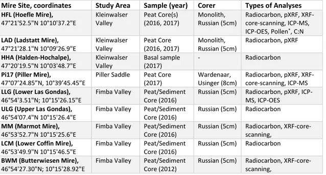
To provide quick information on what has been done, where and which techniques were applied in each of the three valleys and on the different peat cores, an overview is provided in Table 1. More detailed information is following in each of the sub-sections.
Table 1: Summary of all coring sites, coordinates and analyses carried out. *Performed by A. Lange
Mire Site, coordinates Study Area Sample (year) Corer Types of Analyses
HFL (Hoefle Mire), 47°21'52.5"N 10°10'37.2"E Kleinwalser Valley Peat Core(s) (2016, 2017) Monolith, Russian (5cm) Radiocarbon, pXRF, XRF-core-scanning, ICP-MS, ICP-OES, Pollen*, C:N
LAD (Ladstatt Mire),
47°21'28.1"N 10°09'26.9"E Kleinwalser Valley Peat Core (2016, 2017) Monolith, Russian (5cm) Radiocarbon, pXRF HHA (Halden-Hochalpe), 47°20'19.5"N 10°03'48.7"E Kleinwalser Valley Basal sample (2017) - Radiocarbon
Pi17 (Piller Mire),
47°07’24.85”N, 10°39’45.45”E Piller Saddle Peat Core (2017)
Wardenaar, Usinger (8cm)
Radiocarbon, pXRF, XRF-core-scanning, ICP-MS
LLG (Lower Las Gondas),
46°54'3.51"N; 10°15'26.15"E
Fimba Valley Peat/Sediment Core (2016)
Russian (5cm) Radiocarbon, pXRF, ICP-MS, ICP-OES
ULG (Upper Las Gondas),
46°54'07.4"N 10°15'26.4"E
Fimba Valley Peat/Sediment Core (2016)
Russian (5cm) Radiocarbon
MM (Marmot Mire),
46°53'52.7"N 10°15'25.6"E
Fimba Valley Peat/Sediment Core (2016)
Russian (5cm) Radiocarbon, XRF-core-scanning,
LCM (Lower Coffin Mire),
46°53'49.9"N 10°15'46.5"E
Fimba Valley Peat/Sediment Core (2016)
Russian (5cm) Radiocarbon
BWM (Butterwiesen Mire),
46°54'27.30"N; 10°15'28.92"E
Fimba Valley Peat/Sediment Core (2012)
Russian (5cm) Radiocarbon, XRF-core-scanning,
3.1
Coring techniques
The coring of peatlands requires careful planning, which involves the selection of the coring system itself and related equipment. The decision can depend on the properties of the sampled peatland in terms of vegetation, wetness, decomposition and depth but also on the accessibility of the site, as the logistics are not negligible in mountainous environments. Furthermore, the types of planned analyses determine how much material is needed from a single core. In most cases, sampled mires seldomly go deeper than ten metres. The soft material means that peat-coring systems are constructed to be hand-driven. However, due to its softness, compression and other disturbances can occur during coring and need to be avoided. A detailed overview on coring techniques and a guide for a clean procedure from coring to subsampling was published by De Vleeschouwer et al. (2010) and Givelet et al. (2004). The systems and techniques that were used to obtain the peat (sediment) profiles for this study are shortly introduced here in the following:
With the acrotelm being still undecomposed, often with roots of Ericaceae or Pinus mugo embedded within a softer matrix of mosses, retrieving an undisturbed core is particularly
challenging. The simplest technique is the use of a serrated ceramic blade knife. Although the penetration depth is limited, any compaction is negligible.
A more sophisticated system to tackle the issue of coring the topmost metre is the Wardenaar corer (Wardenaar, 1987). The system has a rectangular 10x10x100 cm coring chamber, which is composed out of two connected, but independently moving stainless steel halves. Each side’s lower end is reversely furnished with an inclined, sharpened edge. By pushing each side down stepwise and on a rotating basis, the corer can cut through the usually very fibrous acrotelm with minimum compression. A pillow of air can be created at the lower end of the core before pulling it out, which helps to disconnect the layers and to decrease suction at the lower end. Another advantage is the large quantity of sample material. However, the instrument is less suitable for dense (fen) peat or thick wood and root layers. It is easily damaged (bends, nicks) and, therefore, cannot be driven down with too much force.
For deeper layers, the use of a Russian peat corer is required. This type of corer was first introduced by Belokopytov and Beresnevich (1955) and further developed by Jowsey (1966). It is the most commonly used corer for soft sediments like peat, as it avoids vertical compression and is relatively easy to carry and to use. Theoretically, the maximum depth is limited only by the number of extension rods and the strength of the coring team. It has a semi-cylindrical coring chamber, which can be turned by a handle at the upper end by 180° around the attached blade to close the coring chamber. When retrieving a consecutive second core from the borehole, it is important to consider that the upper 10 cm could be disturbed by the metal tip of the Russian corer. Therefore, the upper 10 cm should be avoided, and a parallel core should be taken with a slight offset to obtain undisturbed material for this part.
The typical radius of the chamber can vary between 2.5 cm, 4 cm and 5 cm, with lengths of either 50 or 100 cm. Like the Wardenaar corer, it is pushed into the ground by hand or hammer blows, with the chamber at 0° position. When the targeted depth is reached, the sharpened edge of the chamber cuts horizontally through the peat. This design avoids vertical compaction, but horizontal compression or an incomplete filling of the chamber can occur in very soft peat. The Russian corer is, hence, most efficient for the catotelm.
Another method was deployed within this work: the Usinger coring system, which is a modified piston coring system (e.g. Livingstone, 1955) initially developed for lake sediments. It was developed further to be used for peat or other soft organic sediments and continuously refined to reach higher depths. The schematic and setup are described in detail by Mingram et al. (2007). It has an outer rod, which transmits the forces of pushing and pulling; and an inner rod, which controls the piston and depth of opening the barrel. The coring chamber is a cylindrical, walled