CIRICE 2016
Delli Aspetti de Paesi Vecchi e nuovi Media per l’Immagine del Paesaggio / Old and new Media for Landscape Image
Derivando i valori del patrimonio culturale: l’uso dei social media
MANAL GINZARLY,JACQUES TELLER
LEMA,Université de Liège,Belgium
Abstract
Nel 2011 l’UNESCO ha adottato la Raccomandazione sul Paesaggio Storico Urbano che mira al riconoscimento e all'identificazione della stratificazione e dell'interconnessione dei valori - naturali e culturali, materiali e immateriali, internazionali e locali – riscontrabili in qualsiasi città storica, concepita come un “patrimonio vivente” delle comunità. In tale visione il patrimonio culturale urbano è un elemento riconosciuto non solo dagli esperti, ma dalle intere società che ne valutano gli elementi identitari mirando a conservarli per le generazioni future.
La Raccomandazione, in particolare, sostiene che per l'interpretazione e la conservazione del patrimonio culturale si può beneficiare di metodi di valutazione tradizionali e di metodi innovativi basati su dati geo-localizzati e sui dati digitali dei social media, come tweets geo-localizzati, impronte digitali e foto su Flickr.
Il presente contributo illustra una metodologia basata sull’analisi delle immagini su Flickr. Dai risultati ottenuti si è evinto che proprio l’indagine dei social media può contribuire ad una comprensione significativa dei valori culturali del contesto urbano, fornendo così la possibilità di una migliore integrazione dei valori socio-culturali riconosciuti dalla collettività nei processi di conservazione e di pianificazione urbana.
Parole chiave:
Cultural heritage, historic urban landscape, digital media, flickr, heritage conservation.
Introduction
I
n the field of urban heritage , a value-based management process to heritage conservation has been recommended (ICOMOS Australia, 1999; UNESCO, 2011). The UNESCO recommendation on the historic urban landscape defines the later as “the result of a historic layering of cultural and natural values and attributes, extending beyond the notion of “historic center” or “ensemble” to include the broader urban context and its geographical setting” [UNESCO 2011,Article 8]. Cultural heritage includes tangible and intangible heritage (UNESCO,2003). It expresses the ways of living and the values of a community where the tangible can only be understood and interpreted through the intangible [Munjeri, 2004]. The later is defined as communities’ practices, expressions, and representations that are the outcome of their interaction with their environment through history, and which provides them a sense of identity (UNESCO, 2003). Accordingly, decisions about cultural heritage preservation are no longer related solely to the tangible historical aspects of heritage but also to the different cultural values embedded in an urban landscape. The diverse typologies of cultural values that range from social to historic, aesthetic, scientific, economic, political, age, recreational, and spiritual [ICOMOS Australia, 1999; Pereira Roders, 2007] challenge practice since different values should be subject to investigation before any decision making [Ferretti & Comino, 2015].Deriving cultural heritage values: the use of social media
MANAL GINZARLY,JACQUES TELLER
The drive to understand and describe the landscape to serve urban planning and design practices led to the development of different survey methods that search for knowledge on human perception of the environment. As early as in the 1960s, Lynch (1960) developed the cognitive mapping method to study the degree of legibility of an urban environment, and extract how people perceive the environment, and navigate through the space. In the 1980s, methods that rely on the use of photos gained popularity in landscape perception analysis. Methods have varied from obtaining responses to a set of photographs that are taken by the experts [Tweed & Sutherland 2007; Ruelle et al. 2013; Deghati Najd et al. 2015] to handing out cameras to interviewees, and then assessing the photos based on the expert (interviewer) personal reading [Dakin 2003]. These two methods largely rely on the assessment of experts because they are based on either their choice of photos or their interpretation of photos.
More recently, digital media and the geospatial revolution led to the development of different methodological tools that rely on geodata, and social media data such as geotagged tweets, digital footprints, and photos on Flickr to interpret different types of interactions between users and their environment.
This paper argues that methods that rely on digital media data could complement traditional survey methods to reveal the different cultural values attributed to urban landscapes. These methods largely depend on users’ assessment of the environment. The data offered by digital media including photos, commentaries, spatial data, and personal data of the user (age, sex, and profession) provides new tools to the understanding of the rational and intuition behind the users. It helps identify places preferred by users, reasons behind these preferences, and different values associated to them.
This paper is structured as follows. Section one reviews a number of digital media based evaluation methods of landscape and examines their application to unveil cultural values associated to urban heritage. Section two focuses on flickr as an example of folksonomy and socio-locative practices. It investigates the opportunities that flickr provide for the discursive interpretation of heritage by communities. Section three assesses a set of 400 photos posted on flickr for Tripoli, Lebanon to extract cultural heritage values and their tangible and intangible aspects. First, it explains the methodology used for the analysis of photos. Then it briefly presents the study area. Afterwards, section four presents the conclusions of the work.
1. Digital Media and Cultural Heritage
People experience places differently depending on their personal cognition and emotions (Dunkel, 2015], and assign accordingly different values to heritage sites. Social media services are facilitating the production and interactive sharing of geospatial information by users revealing insights to users’ activities, preferences, and daily life sensitivities and needs [Stefanidis et al. 2013]. The use of data generated by social media in the service of cultural heritage conservation and management allows the integration of socio-cultural aspects of sites and their inhabitants in the process [Kalay 2008].
Many cultural heritage institutions including museums, libraries, and archives have been using the social media to open the floor for participatory communications with the public [Kalay 2008; Liew 2014]. The participation may occur in two ways. Either the users upload and share their own heritage related images and stories to a site, or they post their comments about a specific heritage related item on the site [Liew 2014].
CIRICE 2016
Delli Aspetti de Paesi Vecchi e nuovi Media per l’Immagine del Paesaggio / Old and new Media for Landscape Image
Within the context of urban cultural heritage conservation, the use of digital media is still very limited. However, a diversity of methods has been proposed to visualize specific behavioral patterns and landscape perceptions based on data from webservices like twitter flickr, google maps, and google earth. These methods could be adapted to determine different cultural heritage values attributed to an urban landscape. For instance, Girardin et al. [2009] used digital footprints that are generated by mobile phones using flickr to quantify urban attractiveness according to locals and visitors. Moreover, different public participation GIS methods that rely on website that is based on google maps were applied to examine relationships between human landscape values and physical landscape character, and to assess the socio-cultural values of public lands [Brown et al.,2014]. De Vries et al. [2013] used the same tool to determine the social landscape value on a national scale. Additionally, Dunkel [2015] analyzed the photos and tags posted on flickr to map and evaluate landscape perception, Frias-Martinez et al. [2012] used georeferenced twitter messages to identify urban land uses, and Stefanidis et al. [2013] used data generated by twitter to trace social networks and hotspots.
The examples presented above show that once the data is extracted from digital media servers it could be analyzed to derive information of interest and could serve multi-purposes investigations. This data reveals geospatial and ambient information at the same time [Stefanidis et al., 2013]. The ambient information is directly related to people’s relation to location. Accordingly, it represents a reliable resource for capturing the intangible aspects of urban heritage.
This article follows the existing methodologies to identify the hotspots in the city, and it goes further in the analysis by investigating the content of photos posted on flickr to extract the cultural values embedded in the tangible aspects of the city.
2. Flickr and related research
Flickr is a photo-sharing social media site that emerged around 2004 and has received significant popularity. It supports photos, personal descriptions (tags), time, and location metadata. Photos posted on flickr are generated in two steps: the act of taking photos, then the act of sharing photos and adding information to them [Nov et al., 2010]. The first action is not only prompted by instant consciousnessand the surrounding environment but by all aspects of personal cognition [Dunkel, 2015]. Van House [2007] identified four social uses of personal photographs: (i) memory, narrative,and identity; (ii) maintaining relationships; (iii) self-representation; and (iv) self expresion. The second action reflects the user’s personal conceptualization and perception of the world because tags encompasses the verbal expression of the visible content of photos to include personal reflections, sentiments, and thoughts [Nov et al., 2010].
Flickr received special attention in diverse studies because of the application programming interface (API) that helps accessing data on flickr automatically. For instance, researchers examined the drivers that motivate users to participate and share information with others [Nov et al.,2010], acknowledged geolocated and tagged photos as reliable resources for generating place interpretation based on users’ perception [Rattenbury & Naaman, 2009], applied a location-tag-vision-based approach to retrieve representative tags and landmarks [Kennedy et al., 2007], and analyzed photos and related tags seperately to identify relationships between landscape features, activities, elements, and qualities [Purves & Edwardes, 2008].
Deriving cultural heritage values: the use of social media
MANAL GINZARLY,JACQUES TELLER
T
his paper proposes the use of flickr for the interpretation of cultural heritage. Our assumption is that photos on flickr offer knowledge about the dynamic social interactions within places, and express moments, experiences, practices, and identities contributing to the understanding of cultural values associated to the built environment. The follwing study is a first attempt based on a desk analysis of flickr content to retrieve heritage values revealed by flickr datasets.3. Methodology
The method used for the analysis of photos and tags on flickr is qualitative and quantitative. First, the data was retrieved throught the use of flickr API documentation. The documentation started by searching for photos in Tripoli, Lebanon within a WOE-ID equal to 56049606, and Bounding Box of 35.7703, 34.3649, 35.8747, 34.4717. This geo information includes the municipal boundary of Tripoli and Al Mina. The search looked for photos with high level of accuracy for location information (street level accuracy), and with an upload date that ranges between 2013 and 2016. The outcome of this search was a set of data in xml format ( other formats could be chosen) that identicates for each photo its id, photographer, title, tags, and other information. Based on this data the photos were assembled by photographer. The total number of photos by photographer was searched. Afterwards, for each user photos were retrieved. Based on the geodata photos were gathered by location. Then, photos of the same location that are taken by the same photographer were combined to a single one to prevent interpretation from being dominated by a single person. Afterwards, this data was used to cluster photos according to their location to differentiate between the most and least photo shot zones in the study area. Once the hot and cold spots were identified, the content of photos was investigated, and this analysis was divided into two parts. The first is quantitative and the second is qualitative. In the begining the tags and titles for the sum of photos were identified to delineate how users describe the different aspects in their photos, and to assemble photos by content for each location. Then, through taking into consideration the outcome of the quantitative analysis, the content of each photo was qualitativaly analyzed to unveil the cultural values embedded in each illustration following the typology of values proposed by Pereira Roders [2007]: social, historic, aesthetic, scientific, economic, age, political, and ecological.
4. Study area
T
he site of analysis is Tripoli, the second capital of Lebanon. The city was founded on the Mediterranean seaside during the 14th century BCE. It was not until the Middle age that Tripoli became a city with two poles: The marine city (El-Mina), original site of Tripoli, and the Medina, currently the Medieval Mamluk core [Gulick, 1967]. In 1289 the Mamluks conquered the crusader city that was situated on the peninsula razed it to the ground and built a city at the foot of the crusader citadel and along the Abu Ali River around 3 Km to the west [Gulick, 1967]. Tripoli is the second best conserved Mamluk city after Cairo [Nahas, 2001]. It has 195 monuments from the Mamluk and Ottoman periods and different conserved Mamluk commercial streets. The streets are characterized by their type and function.They are narrow ,covered and each street is specified to a precise artefact orCIRICE 2016
Delli Aspetti de Paesi Vecchi e nuovi Media per l’Immagine del Paesaggio / Old and new Media for Landscape Image
production and is named accordingly, such as Jewelers’ market, shoemakers’ market, copper market, and spices market. The coastal plain has 17 km of seashore with mixed land use nowadays: recreational, residential, zones under construction, agricultural zones, and two harbours: a commercial and a fishing port . Moreover, the city has four offshore islands. The largest island is called the island of palm trees and it is a natural reserve for green turtles, rare birds and rabbits.
4.1. Results and findings
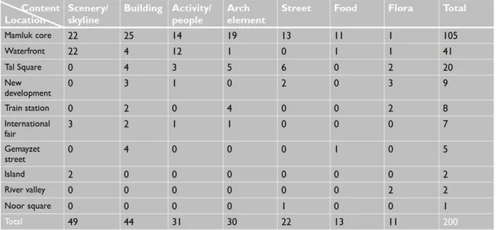
Between January 2013 and April 2016, 410 photos were posted on flickr for Tripoli. These photos were accumulated by photogpraher, and accordingly 71 photographers were distinguished. The rate of participaton varies a lot between them. Fifty five of flickr users posted between one and five photos, fifteen posted between six and thirty photos, and one of them posted more than thirty photos. Based on these results, and to have an interpretation that represents all flickr users. Photos of the same photographer and same location are considered as one in the coming quantitative analysis. As a result, the total number of photos that were investigated was 202. Depending on the geographical information associated with the different photos, the hot spots were identified. The outcome showed that most of the photos are taken in the Mamluk core. The second hot area is the waterfront followed by the ottoman tal square. Urban development between the historic core and the waterfront, the train station which is the only industrial heritage that goes back to the french mandate, and the international fair designed by the achitect Oscar Neimeyer are given less attention by photographers (Tab. 1). The search for tags showed that around 100 different tags were used in the description of photos, the total amount of tags is 350. The most used ones are : architecture, city, skyline, buildings, water, shore, landscape, and seaside (Chart 1). Moreover, almost 75% of the tags were used one or two times, and the rest of the tags were used between three and fourteen times. It is worth to mention that the sentence “Tripoli Lebanon” was not taken into consideration in the analysis of tags since it labels all the photos in the study area.
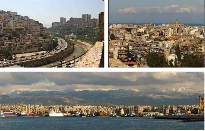
The theme of each photo was defined based on the dominant content, since one illustration could have different sub contents. The most frequent photos are those that show the skyline of the city and urban landscape scenery. The most popular vintage points are : the west bank of the Abu Ali River in the Mamluk core, and the sea shore showing the boats, and the skyline of the city on the waterfront (fig. 1-3). This result shows how landscape preferences are dominated by figures that represent the city within its wider context, and express the different geographical, typological, natural, and built charactersitics of the city. What ranked second are buildings (fig. 4-5). These are mostly photos of Mamluk historic buildings showing the interior as well as the architecture of these buildings. The most posted monuments are the citadel, the great mosque, taynal mosque, khan al khiyatin, and the hamams. The architectural elements and activities had almost the same result followed by streets, food, and vegetation.The third category (activities and people) illustrateas how photographers are not only interested with the tangible aspects of the city but also with its intangible aspects. These photos show the inhabitants of the city and their daily practices. They show the workers, shoppers, kids playing on the street, elderly sitting and playing chess on the sidewalk, people sitting on the seaside or even swimming, eating, and reading (fig. 6-7). The streets photos show how all the commercial streets are vibrant and crowded, and how the street vendors claim
Deriving cultural heritage values: the use of social media
MANAL GINZARLY,JACQUES TELLER
the sidewalks to give a unique character to the area. An important industry that is also presented in these photos is food.
Tab. 1: The total number of photos for each location, and the total number of photos by content for each location and for the entire study area (The author).
CIRICE 2016
Delli Aspetti de Paesi Vecchi e nuovi Media per l’Immagine del Paesaggio / Old and new Media for Landscape Image
Fig. 1: Tripoli Mamluk core. The east bank of the Abu Ali River and part of the west bank. Stephane Akkaoul. Flickr, 05/04/2013.
Fig. 2: Tripoli Mamluk core with the Mediterranean Sea in the background. Antoine.A. Flickr, 21/02/2015. Fig. 3: Tripoli El Mina skyline with the mountains in the background. Antoine.A. Flickr, 22/06/2015.
Fig. 4: Tripoli, great mosque. Christina Smirnova. Flickr, 01/ 04/2013. Fig. 5: Tripoli, taynal mosque. Cazz. Flickr, 20/02/2013.
Deriving cultural heritage values: the use of social media
MANAL GINZARLY,JACQUES TELLER
Fig. 6: Tripoli, Tal area. Bahaa Jamal. Flickr, 14/10/2014.
Fig. 7: Tripoli, Mamluk core vegetable market. Ibrahim Anouty. Flickr, 14/11/2013
Finally, photos were interpreted to extract the cultural value embedded in every illustration. The following will show how photos are analyzed through four examples. Figure one represents one of the most common photos for the study area. This photo is taken from the citadel. It shows the east south of the Abu Ali River. This section of the east bank of the river overlook what is listed as heritage by urban planners and experts but is not included within the boundary of the historic Mamluk core, and was never considered as part of the city’s urban heritage. However, this urban landscape scenery constitutes a unique expression of the city. It embeds an ecological spiritual value in the spatial relation between the built structure, the topography, and the river structure. It also has a unique historic conceptual value since it retains conceptual signs of architectural, urban planning, as well as informal practices in the city that contribute to the character of the urban fabric. In the sum of photos posted on flickr none of the photographers has crossed the notional line that has been drawn by the authority between the two sides of the river, but the topography of the area provides a strong visual connection between both sides and most photos taken from the citadel show the vista that adds to this scenery a landscape aesthetical value. Figure three focuses on the unique character of the landscape. It illustrates the skyline of the city along the seaside and the mountains in the background. The aim is to display the proximity of the sea to the mountains and the landscape aesthetical value of the city. Moreover, the focus on the natural landscape is an intention to shed light on existing ecological assets in the area and their value within the built landscape. This illustration also shows the hybrid port to reflect its economic value. Figure six illustrates how men in the tal area claim the streets. They put chairs out on the street to reserve their spot and gather. Figure seven shows the vegetable market, and how it is dominated by women who most of them are wearing veil. These two photos show how the public space is dominated by social norms that are based on traditions and religion. They give an idea about the gender dynamics in the public sphere. Accordingly, these photos embed a social spiritual value.
This analysis clarifies how the interpretation of photos could help reflecting users’ conceptualization and perception of the world. It also reveals that one photo could project different cultural values. The following chart summarizes the result of the analysis of fourteen photos (two photos from each content).
CIRICE 2016
Delli Aspetti de Paesi Vecchi e nuovi Media per l’Immagine del Paesaggio / Old and new Media for Landscape Image
Chart 2: Cultural values associated to Tripoli’s urban landscape based on the qualitative analysis of fourteen photos posted on flickr.
5. Conclusion
Social media provides new data source that reveals information about users’ landscape preferences and conceptualization. This data if analyzed, it could complement traditional survey methods to unveil the interaction between users and their urban environment. This article focused on the use of flickr to retrieve different cultural heritage values attributed to an urban landscape as to guide future conservation as well as development practices. The analysis targeted a small amount of photos but it conveys a primary interpretation of existing cultural heritage assets in the city. Moreover, the methodology used has its limitation. However, it provides a foundation for further research especially in the analysis of photos’ content to go beyond their tangible illustrative aspects.
Value is the main reason for heritage conservation, and this goes much beyond the historic and age values to include social, political, and ecological values. The identification of such values calls for more public involvement in the process and the social media opens the floor for such initiatives. Moreover, such a bottom up approach will result in more acceptance for conservation practices and policies since decisions rely on knowledge that comes from the public sphere.
Bibliography
Brown, G., Weber, D., & de Bie, K. (2014). Assessing the value of public lands using public participation GIS (PPGIS) and social landscape metrics. Applied Geography, 53, 77–89.
Dakin, S. (2003). There’s more to landscape than meets the eye: towards inclusive landscape assessment in resource and environmental management. Canadian Geographer / Le Géographe Canadien, 47(2), 185–200.
Deriving cultural heritage values: the use of social media
MANAL GINZARLY,JACQUES TELLER
De Vries, S., Buijs, A. E., Langers, F., Farjon, H., van Hinsberg, A., & Sijtsma, F. J. (2013). Measuring the attractiveness of Dutch landscapes: Identifying national hotspots of highly valued places using Google Maps. Applied Geography, 45, 220–229.
Deghati Najd, M., Ismail, N. A., Maulan, S., Mohd Yunos, M. Y., & Dabbagh Niya, M. (2015). Visual preference dimensions of historic urban areas: The determinants for urban heritage conservation. Habitat International, 49, 115–125.
Dunkel, A. (2015). Visualizing the perceived environment using crowdsourced photo geodata. Landscape and Urban Planning, 142, 173–186.
Ferretti, V., & Comino, E. (2015). An integrated framework to assess complex cultural and natural heritage systems with Multi-Attribute Value Theory. Journal of Cultural Heritage, 16(5), 688–697.
Frias-Martinez, V., Soto, V., Hohwald, H., & Frias-Martinez, E. (2012). Characterizing Urban Landscapes Using Geolocated Tweets (pp. 239–248). International Conference on Social Computing
(SocialCom), IEEE.
Girardin, F., Vaccari, A., Gerber, A., Biderman, A., & Ratti, C. (2009). quantifying urban attractiveness from the distribution and density of digital footprints. International Journal of Spatial Data Infrastructures Research, 4, 175–200.
Gulick, J. (1967). Tripoli: A Modern Arab City. Harvard University Press.
ICOMOS Australia. (1999). The Australia ICOMOS charter for the Conservation and Restoration of Places of Cultural Significance.
Kalay, Y. E. (2008). Preserving cultural heritage through digital media. In New Heritage: New media and cultural heritage (pp. 1–10). Routledge.
Kennedy, L., Naaman, M., Ahern, S., Nair, R., & Rattenbury, T. (2007). How flickr helps us make sense of the world: context and content in community-contributed media collections (p. 631). ACM Press. Liew, C. L. (2014). Participatory Cultural Heritage: A Tale of Two Institutions’ Use of Social Media. D-Lib
Magazine, 20(3/4).
Lynch, K. (1960). The Image of the City. MIT Press.
Nahas,C. (2010). Stakeholder analysis and social assessment for the proposed cultural heritage and tourism development project,Tripoli,Chapter 5,64-106.
Nov, O., Naaman, M., & Ye, C. (2010). Analysis of participation in an online photo-sharing community: A multidimensional perspective. Journal of the American Society for Information Science and Technology, 61(3), 555–566.
Pereira Roders, A. (2007). RE‐ARCHITECTURE: Lifespan Rehabilitation of Built Heritage. Eindhoven:Eindhoven University of Technology.
Purves, R., & Edwardes, A. (2008). Exploiting volunteered geographic informa-tion to describe place (pp. 252–255). Presented at the Proceedings of GIS research UK 16th annual conference Manchester. Rattenbury, T., & Naaman, M. (2009). Methods for extracting place semantics from Flickr tags. ACM
Transactions on the Web, 3(1), 1–30.
Ruelle, C., Halleux, J.-M., & Teller, J. (2013). Landscape Quality and Brownfield Regeneration: A Community Investigation Approach Inspired by Landscape Preference Studies. Landscape Research, 38(1), 75– 99.
Stefanidis, A., Crooks, A., & Radzikowski, J. (2013). Harvesting ambient geospatial information from social media feeds. GeoJournal, 78(2), 319–338.
Tweed, C., & Sutherland, M. (2007). Built cultural heritage and sustainable urban development. Landscape and Urban Planning, 83(1), 62–69.
UNESCO. (2003). Text of the Convention for the Safeguarding of the Intangible Cultural Heritage. UNESCO. (2011). Recommendation on the historic urban landscape. UNESCO World Heritage
Centre:Paris,France.
Van House, N. (2007). Flickr and public image-sharing: Distant closeness and photo exhibition. In CHI ’07 Extended Abstracts on Human Factors in Computing Systems (pp. 2717–2722). New York: ACM Press.
Sitography