Learning for resilience
Insights from Cambodia's rural communities
Chapter 7 - Pathways of change in a coastal resource
system: Study from Kampong Trach district, Kampot
province
VOE Pisidh, TOUCH Panha and Jean-Christophe DIEPART
Suggested citation: Voe, P., Touch, P. and Diepart, J.-C. (2015) Pathways of change
in a coastal resource system: Study from Kampong Trach district, Kampot province.
in Diepart, J.-C., (ed.) Learning for resilience: Insights from Cambodia’s rural
communi-ties, Phnom Penh: The Learning Institute. pp. 179-204.
The Learning Institute
2015
Sec
ti
on
D
Pathways of change in
a coastal resource system: Study from
Kampong Trach district, Kampot province
CHAPTER 7
Over the past several years, Cambodia’s coastal resources system has undergone considerable transformation. The causes have included uncontrolled fishing activities, tourism development, salt and shrimp farming, sand mining, and trade, to name just the most significant. Against this background, this study analyzes pathways of change over the past 15 years in coastal resource systems in two neighboring communities in the Kampong Trach district of Kampot province. The analysis proceeds on two different levels. We first look at change in respect of the cross-scale multiple drivers in the resource system at village level and its effects on the social and ecological components of the marine, intertidal and agricultural areas of the coastal zone. Then, at household level, we examine the diversity of adaptation measures adopted to deal with these changes, and evaluate their impacts on livelihoods.
We argue that the degradation of fisheries resources in marine and intertidal zones results from drivers that originate outside and inside the communities, but mostly stems from problems of governance. Despite tangible improvements in rain-fed rice yield, the development of the farming sector is constrained by limited capacity to diversify and intensify production. The adaptation paths to this resources degradation squeeze are multiple.
The few households who can afford to enhance or intensify their farming and fishing efforts usually manage to improve their food security status. But in a majority of cases, the adaptation works through a move away from the land and the sea, either through self-employed non-farm and non-fishing activities (local business associated with cross-border trade with Vietnam) or through wage labor. Self-employed activities and demand more capital but represent the main path of improvement in these communities. Wage labor - particularly associated with migration - has become widespread but its potential to improve food security is very limited. Accessing credit and going into debt is another significant way in which people have attempted to adapt either to address chronic food insecurity or to maintain the same level of productivity.
VOE Pisidh, TOUCH Panha and Jean-Christophe DIEPART
Key words: coastal area, fisheries management, small-scale fisheries, livelihood, social mobility
INTRODUCTION
In the coastal regions of Cambodia, the majority of households rely on fishing activities for their livelihoods. However, some are employed in farming, self-employed non-farm and wage labor activities, while others have migrated to find jobs and remittance money for their family (Marschke 2012). In the coastal province of Kampot most households are engaged in rice farming (Rizvi and Singer 2011). But for coastal people who depend on coastal aquatic resources, opportunities have emerged from both social and ecosystem (and species) diversity that have provided households with a wide range of resources. These have enabled them to cope or adapt under changing and often highly uncertain social, economic and environmental conditions. Livelihood diversification is essential for developing sustainable livelihood strategies and thus constitutes a crucial element in individual and community well-being (Brugère et al. 2008, Campbell et al. 2005).
Cambodia’s coastal resources have changed over the past several years under the influence of several factors. These have included uncontrolled post-war resource exploitation, lack of coordinated management in trans-boundary water resources, degradation of the mangrove ecosystem and seagrass beds associated with development of salt farms and fish farming, and the rapid economic development driven by, for instance, tourism (Campbell et al. 2005, Marschke 2012).
This study analyzes pathways of change in coastal resource systems in two communities. The analysis proceeds on two levels. We look first at change and the associated cross-scale multiple drivers in the resource system at village level, along with the effects these drivers have had on the social and ecological components of the marine, intertidal and agricultural areas of the coastal zone. A central hypothesis is that the changes in the resource system have induced differential transformations in the production processes at the household level. Secondly, we examine these household level transformations for different types of household production systems. We look at the diversity of adaptation measures taken to deal with these changes and assess their impacts on livelihoods.
The increase of mobility is a central element in adaptation strategy adopted by many who have been affected. This includes: mobility of labor (non-farm, wage and migration); the mobility of capital (e.g. conversion from marine zone fishing to trade); and mobility of landownership (occurring through market-based land concentration). However, we suggest that these processes of adaptation have actually reinforced the wealth disparity that exists between households. It has particularly exacerbated the vulnerability of those who are most dependent on small-scale fisheries.
Sec
ti
on
D
ENVIRONMENTAL CHANGE IN COASTAL CAMBODIA
Although in the UN classifications Cambodia is still a ‘least developed’ country, it is, nevertheless, resource rich. However, after 20 years of war (1970-1990) and recent post-conflict exploitation, all resources, including coastal fisheries in Cambodia, have suffered sharp declines. Forests have traditionally seen the most serious decrease but other resources such as inland fisheries and mangrove-based harvesting have also been heavily depleted (Le Billon 2000, Un and So 2009). Other resources, such as offshore oil and gas, must also be taken into account as moves to extract those continue to develop (Cock 2010). A strong reduction has now been registered in catch per unit effort (CPUE) of fisheries resources, while the use of different fishing gears is reported to have significantly increased. The decline of resources and the subsequent impact of this on communities differ from one specific area to another (So and Touch 2011). For example, degradation of fish stocks in the Gulf of Thailand is caused primarily by the destructive fishing practices of both inshore coastal fishers and foreign over-fishing, or from illegal operations in offshore areas (NACA 2004). In the Memorandum of Understanding (MoU) between the Kieng Giang province of Vietnam and Kampot province in Cambodia (2008), the use of illegal fishing gear by both Cambodian and Vietnamese fishers in trans-boundary areas was highlighted as a matter of concern to be curtailed. The increased number of fishing boats and the use of modern fishing equipment is diminishing resources and habitats. This directly leads to habitat degradation and a decline in local fish stocks. There is also a concern about current rates of shoreline and offshore island tourism development. This development lacks transparent and accountable environmental and im-pact assessment processes and there is a general lack of local public input that would help in understanding and controlling it (Ouk et al. 2012).
Additional factors that challenge sustainable coastal resource management in Cambodia include a lack of coordinated management in trans-boundary waters and fishing disputes with Vietnam and Thailand. Furthermore, a lack of community-level awareness about law enforcement, in conjunction with the long-term sustainable use of resources, is still limited as local people concentrate on securing direct, short-term benefits.
Within Cambodia, all the living resources in the marine zone are under the direct management of the Fisheries Administration. Marine resources are ruled by the new Fisheries Law, which came into force in 2006 (Royal Government of Cambodia 2006). Cambodian fisheries, in both marine and coastal waters, are governed through the process of establishing Community Fisheries (CFis) of which, by 2013, 360 had been registered throughout the country. These arrangements represent attempts by the central government to decentralize fisheries management, conservation and enforcement efforts to a more local level. However, this system remains highly centralized and suffers from a number of governance shortcomings. For example, enforcement of rules and regulations associated with Community Fisheries is not effective due to the weak capacity and cross-level corruption of authorities that is evident in both Keng Kiang and Kampot.
Mangroves are trees and shrubs found in intertidal zones of coastal areas that have adapted to living in saline water, either continually or during high tides (Duke 1992). The importance and quality of the various goods and services provided by mangroves varies depending on location (Ewel et al. 1998). However, they do provide many critical ecosystem services to support coastal livelihoods. They play a key role in stabilizing land, cycling nutrients, processing pollutants, supporting nursery habitats for marine organisms and providing fuel wood, timber and fisheries resources. Moreover, they serve as key fish nursery grounds and thus link seagrass beds with associated coral reefs (Orth et al. 2006, Food and Agricultural Organization 2005, Mumby et al. 2004). Destruction of mangroves can thus interrupt these links, damage biodiversity and thus lower the productivity in reef and seagrass biomes (Alongi 2002). Rizvi and Singer 2011 also describe declines in fish stock due to increased fishing activity and the loss of mangrove forest. Documenting an impact assessment survey carried out in the context of the Rural Development Program in Kampot, supported by GTZ (the German agency for technical cooperation), Degens and Choun (2007) have shown that when mangrove forests are kept intact or regrown through community mobilization, ecosystem services are maintained and there is an increase in fisheries and other aquatic animal (OAA) resources.
Mangrove areas worldwide have become degraded and their conversion to other uses is widespread. These other uses have included the development of aquaculture, agriculture and the establishment of salt farms (Farnsworth and Ellison 1997). Among four municipalities and provinces where mangrove forests have traditionally existed, those in Kampot and Sihanoukville have been destroyed (MOE and DANIDA 2002). Mangrove forests are being cleared illegally for use as firewood, for the production of charcoal, to create saltpans, as part of land reclamation activity and to promote intensive shrimp aquaculture, among other activities (Johnsen and Munford 2012). Even when mangrove forests are theoretically protected by the Fisheries Administration (FiA) and Ministry of Environment (MOE), efforts to prevent illegal cutting are often ineffective (IUCN 2013, Johnsen and Munford 2012). Seagrass meadows are also a key part of the intertidal zone where they are closely linked to mangrove forests, and those in Kampot are the largest in Southeast Asia (Kirkman and Kirkman 2002). Seagrass habitats play a critical role in supporting fisheries, in preventing erosion, providing storm protection, conserving biodiversity and in sequestering atmospheric carbon. They are important nursery and feeding grounds for many species of fish, including endangered species such as dugongs and seahorses. Seagrass meadows have been destroyed or extensively degraded as a result of unsustainable inshore fishing practices (Unsworth 2014, Unsworth and Cullen 2010).
In Kampot province salt farms are commonly found along the coast, although most are located close to paddy fields with the result that salt water leaks into these fields damaging the crop. The extensive degradation of coastal natural resources, including the loss of valuable forests, wildlife, fisheries resources, mangroves, coral reefs, and seagrasses, has led to an overall worsening of coastal social-economic conditions (Monyneath 2000).
Sec
ti
on
D
METHODOLOGY
Analytical framework
Coastal environmental systems are among the most biologically productive social-ecological systems in the world (Turner et al. 1999). They have important ecosystem functions and provide important services for people who depend on them. For instance, mangroves, seagrass beds and coastal marshes provide habitat for juvenile fishes (ecosystem function), which can ultimately contribute to commercial and recreational fish landings (ecosystem service). They also have a role in wave attenuation (ecosystem function), which may protect coastal property from storm surge (ecosystem service) (Granek et al. 2010). Unfortunately, recent evidence shows that many human activities have severely diminished coastal ecosystem integrity and consequently the well-being of the people who depend on them. The coastal system is subject to different drivers of change that can be natural or human-generated and can directly or indirectly cause a change in the ecosystem’s structure-function relationships (Newkirk 1996). These drivers or change agents, individually or acting together, can profoundly influence the overall state and productivity of the ecosystem (e.g. the fish yield) (Mumby et al. 2004). In this study we examined changes in the coastal social-ecological system in three subtype areas; inland areas (land-based areas influenced by sea water - e.g. rice farming and residential areas), intertidal areas (areas where fresh water and saltwater mix), and marine (inshore/offshore) fisheries systems (deeper zones where local people interact through fishing activities).
Directly connected to previous analyses on change in social-ecological systems, this research considered the effects that changes in the coastal system have had on the ability of households and communities to achieve food security. Impacts can be two-fold: they either create new opportunities (a higher quantity and/or improved diversity of natural products) or they can negatively affect the security of local livelihoods by degrading the essential natural-resource base. These effects and impacts are diverse and the research team examined this diversity closely, basing their study on several key aspects: the variation of change and impacts from one place to another and within communities, and the different responses made by households to deal with these changes and impacts. We then analyzed these differences as they were manifested in different income generation strategies determined by individual household assets and entitlements. This process is called social-economic differentiation (Bernstein 2010), and leads to a new distribution of resources and activities within communities, new social relations in production activities and different income formation mechanisms that result in an increasing wealth gap between households. To elicit the diversity of change at household level, we first established a typology based on the nature of house-hold members’ production activities (farming, fishing, self-employed or wage off-farm activities) and the way these activities were combined within the household production system. We then identified different paths of adaptation prevailing in both coastal communities that were the focus of the study, and examined their relevance to the different types of production system. This facilitated an assessment of the efficiency of these adaptation paths in supporting household well-being.
Study area
Cambodia’s coastline stretches for 435 kilometres and covers an area of approximately 18,000 km2 (Rizvi and Singer 2011). The coastline area comprises four municipalities and the provinces of Kampot, Kep, Preah Sihanouk and Koh Kong, which have a combined population of well over 1 million people (National Institute of Statistics 2013). The topography of the coastal area includes mountains, plateau, plain, coastal zone, seaside and gulf, and it is connected closely to other ecosystems including those associated with beaches, forest and coastal strand vegetation, and mangroves (including a Melaleuca dominated swamp forest). There are also estuarine ecosystems, seagrass meadows, coral reefs and a gently sloping, relatively shallow seabed. One of the four coastal provinces, Kampot is located in Southwest Cambodia and has a total coastline spanning about 73 kilometers, stretching from the border of Hatieng district, Vietnam, to Koh Ses, Prey Nup district, Preah Sihanouk province (Rizvi and Singer 2011).
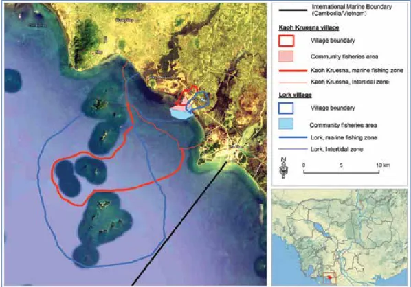
This research was conducted in two villages, Kaoh Kruesna (10o27’50 N, 104o 26’ 09 E and elevation 3m) and Lok (10o26’50 N, 104o26’25 and elevation 6m) in the Kampong Trach district of Kampot province. Both villages are coastal and lie near the border with Ha Tien, Vietnam. The research study identified three zones of resource change, farming, intertidal and marine (Figures 1 and 2). The farming zone of both villages is dominated by wet rice agriculture, yam production and dry season crops (Figure 2). Livestock constitute a further focus. The intertidal zone contains mangroves and seagrass beds, and a small fraction of this has been established two Community Fishery areas (one Community Fishery in each village) and is used by fishers from both villages (Figure 1). The marine zone (also referred to as ‘offshore’) embraces fishing areas beyond the intertidal zone.
The villages have different demographic and social-economic profiles. As of 2012 (NCDD 2012), the total population was 1,242 people (233 households) and 2,949 people (637 households) in Kaoh Kruesna and Lork, respectively, with population density much higher in Lork than in Kaoh Kruesna (632 and 333 people per square kilometer, respectively). As a further comparison, Kaoh Kruesna households rely more than their Lork counterparts on a combination of farming and fishing, but, proportionally, Kaoh Kruesna villagers are more dependent on fisheries than their fellows from Lork village. Within its commune, Lork village is a relatively important trade center with a much more dense settlement structure. Most households rely on agricultural and off-farm activities but some households located closer to the reef also depend on fishing activities.
Sec
ti
on
D
Figure 1: Fishing zones of the two villages
Fieldwork and data collection
Commune level data was gathered using Participatory Rural Assessment (PRA) tools, and qualitative data gained from discussions with members of each community. The selection of participants for the PRA (n=12) was based on the activity in which they were engaged (farming, fishing activities or both). A checklist was used to guide questions about the change in resource use. An additional discussion elicited details of change in the period from 1993-2004, which was when Community Fisheries (CFis) were established for both villages. The second part of the discussion covered the period after CFis were established (2004-2012). Semi-structured interviews were used to further explore the changing history of household (HH) resource use. The HHs interviewed (n=101, 42 in Kaoh Kruesna and 59 in Lork) were selected randomly based on the Yamane Taro formula (Israel 1992).
To analyze the change in resource use at the commune level, we identified drivers of change in the three zones (farming, intertidal and marine) over the period 1993-2012. The analysis used both commune data and relevant literature. A 2005 aerial photo acquired on the Google Earth server was used to identify land use and cover changes (LUCC) in the community. These include the loss of mangrove forest area, expansion of salt farms, and damage to rice cultivation areas caused by high tides and storm surge. This helped to identify changes in the physical environment linked with local social-economic impacts. The second data analysis looked at the impact the change in resource availability had exerted on livelihoods.
THE EVOLUTIONARY PROCESS OF RESOURCE CHANGE
OVER THE PAST 15 YEARS
Evolution in the farming zone
Rice cropping and small-scale livestock reemerged in the 1980s after the war and political instability that prevailed in the area between 1970 and 1979.
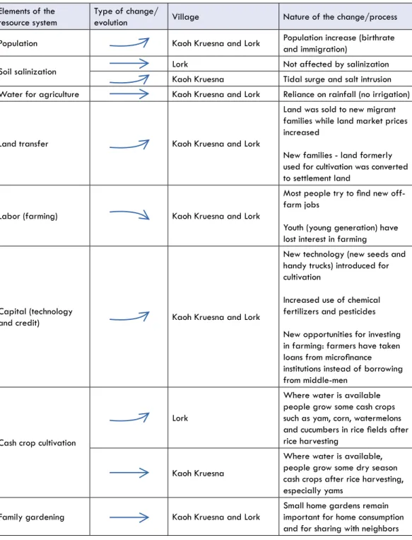
From 2005 to 2013, rain-fed rice yield increased from 0.8 tonnes per hectare to 2 tonnes per hectare [CDB online and commune statistics] as a result of several factors that are best understood together (Table 1). The post-war demographic increase (natural increase and in-migration) has put pressure on land resources in a context where agrarian expansion into upland forest has been impossible and where a lack of irrigation has prevented the intensification of production. Soil salinization resulting from rainy season storm surge and saltwater intrusion into rice fields has complicated the problem of land availability (Figure 2). A rapid process of landholding fragmentation has resulted in a decreasing land area size per family. In this context, the need to boost rice production for increased food demand has been met through a combination of new farming technologies (e.g. increased use of fertilizers and pesticides) and, above all, through the intensification of labor. This process of intensification has been driven primarily by households. Dry season agricultural diversification into yam production has occurred where water has been available and where the land has not been affected by saltwater intrusion. But overall, the possibility to further intensify and diversify
Sec
ti
on
D
the agricultural production is now limited from an institutional point of view because farmers receive little support from the Provincial Department of Agriculture to improve technical itineraries, support agricultural innovation and facilitate access to market.
Table 1: Resource change in the farming zone during the past 15 years
Elements of the
resource system Type of change/evolution Village Nature of the change/process Population Kaoh Kruesna and Lork Population increase (birthrate and immigration) Soil salinization Lork Not affected by salinization
Kaoh Kruesna Tidal surge and salt intrusion Water for agriculture Kaoh Kruesna and Lork Reliance on rainfall (no irrigation)
Land transfer Kaoh Kruesna and Lork
Land was sold to new migrant families while land market prices increased
New families - land formerly used for cultivation was converted to settlement land
Labor (farming) Kaoh Kruesna and Lork
Most people try to find new off-farm jobs
Youth (young generation) have lost interest in farming
Capital (technology
and credit) Kaoh Kruesna and Lork
New technology (new seeds and handy trucks) introduced for cultivation
Increased use of chemical fertilizers and pesticides New opportunities for investing in farming: farmers have taken loans from microfinance institutions instead of borrowing from middle-men
Cash crop cultivation
Lork
Where water is available people grow some cash crops such as yam, corn, watermelons and cucumbers in rice fields after rice harvesting
Kaoh Kruesna
Where water is available, people grow some dry season cash crops after rice harvesting, especially yams
Family gardening Kaoh Kruesna and Lork Small home gardens remain important for home consumption and for sharing with neighbors
Evolution in the intertidal zone
The intertidal zone is located close to inland communities (Figure 1). It consists of three sub- zones, reef, mangroves and seagrass. The intertidal zone provides a critical habitat for other aquatic animals (OAAs) which are key elements of local diets. Some households close to the area glean OAAs by going out on rowing boats using traps, and hand collecting during low tides. Crabs are the most popular species of OAA. The fishermen who glean these resources lack the necessary capital to purchase boat engines and fishing equipment (Gillett 2004). This zone has undergone significant changes in resource availability and governance. During the period from 1993 to 2004, fish and OAA resources declined due to widespread mangrove clearing for building materials and firewood, conversion to salt pans, aquaculture, and existing salt farm expansion. Beyond the mangrove forests, seagrass beds were destroyed by outsiders using large trawlers. Throughout this time, given the scope of change and actors involved, the local authorities were relatively powerless to control illegal fishing or to ensure conservation in the intertidal zone.
Starting in 2004, a Community Fishery (CFi) was established in the intertidal area in each village to protect the mangrove forest and to improve fisheries practices in the area (the Community Fisheries areas are shown in Figure 1). The initiative was first supported by the GTZ Rural Development Program (Kampong Thom-Kampot) to boost the extent of the mangrove forest area and to enhance seagrass bed conservation (Degens and Choun 2007). Regulations were also designed to enforce or implement some form of sustainable resource co-management in partnership with the Fisheries Administration (FiA). Mangroves were replanted, local authorities and management committees were supported along with FiA staff to patrol the area (Table 2). The impact assessment made by Degens and Choun (2007) indicates the success of these efforts in terms of governance, as well as fish diversity and productivity.
But there is a strong contrast in the way the CFis have developed in each village. In Lork, the CFi is less functional as people are much more engaged in farming and cross-border trade and are consequently not as dependent on intertidal fishing as their Kaoh Kruesna counterparts. Their CFi is neglected as a result. In Kaoh Kruesna the higher dependence of the population on fisheries resources creates more incentive and better control of resources in the CFi areas.
However, the withdrawal of the GTZ efforts in supporting the Community Fisheries schemes has revealed the weakness of the CFis that were put in place. Without the back-up provided by GTZ, the Community Fisheries scheme has had very limited capacity to generate revenue that could have financed the patrolling of the area or supported management operations. This lack of resources and the impact of illegal fishing form the narrative that local authorities and CFi committees continually use to explain their lack of active implementation of the CFi management plans and rules with local fishers and CFi members. So in the context of dynamic transformations in the economy and resource systems, Community Fisheries are not currently functioning as a comprehensive and adequate solution to the many challenges
Sec
ti
on
D
facing fisheries management. Another important issue is scale. The intertidal area where the Community Fisheries regulations are actually applied is rather small in comparison with the total intertidal area used by fisher folk (Figure 1). These CFi restrictions are thus easily circumvented by local fishers who simply operate in the areas outside of that designated as ‘Community Fisheries’ where a more business-as-usual attitude prevails.
After 2011, given that the CFi institutions were unable to properly manage and protect fisheries resources, the resources in the intertidal zone underwent further degradation. To adapt to this degradation, a number of fishermen (at least those who could afford it) decided to upgrade their boat engines (to small-scale motorboats greater than 10HP (horsepower)) and relocate their fishing efforts offshore where they were able to target crab as the main species around offshore islands (Figure 1). These new fishing grounds are much larger than those in the intertidal zone, so the competition between fishermen is lessened.
Table 2: Resource change in the intertidal zone during the past 15 years
Elements of the resources system
Type of change/
evolution Village Nature of the change/process Pollution Kaoh Kruesna and Lork There is continued but low impact on fishery resources and mangroves in
the intertidal areas Aquaculture
development projects Kaoh Kruesna and Lork
Large shrimp farms were initiated before 2005 - expanding into the mangrove area - but they were cancelled after the creation of the CFis Law enforcement Kaoh Kruesna and Lork
Despite the period when the CFis were active (2004-2011), there was weak law enforcement which has led to massive and illegal over-extraction of resources (destruction of mangrove forest, land development, and so on) Salt farms Kaoh Kruesna and Lork Some altered mangrove forest areas were converted to salt farms Number of large-sized
fishing vessels (10- 30HP)
Kaoh Kruesna and Lork In 2008 poles were placed in the CFi area to prevent trawling boats from crossing the CFi boundary
Number of medium-sized fishing vessels
(<10 HP) Kaoh Kruesna and Lork
People move in or out depending on whether or not they have sufficient labor to fish in the marine zone Rowing boats Kaoh Kruesna and Lork
Fishermen using rowing boats move to the marine fishing zone and opt for small-scale motorboats for crab fishing around off-shore islands
Fishing tools Kaoh Kruesna and Lork
CFi regulations restrict the use of fishing gear, types and net mesh sizes. But there has been no major change in the type of fishing tools used What has changed is the number of tools used per fisherman
Evolution in the marine zone
The marine fishing zones of Kaoh Kruesna and Lork villages are located in trans-boundary waters between Kampot province (Cambodia) and Kie Giang province (Vietnam). Some of this zone is used by fishers from both Cambodia and Vietnam as the marine boundaries remain contested and thus ignored and there are no clearly defined fishing areas (Anonymous 2008).
Most fishers in this zone use either medium- or large-scale fishing gear. Some fishers use (large-scale) trawlers for multi-species fishing, whereas medium-scale fishers use traps for crab. But the resources in this zone have declined since 1993 when Cambodia adopted a free market approach to natural resource management. The decline of resources is due to increasing numbers of fishing boats from inside and outside the provincial Cambodian community (Vietnamese fishers) because this zone lacks clear and enforced boundaries (Table 3).
Table 3: Resource change in the marine zone in the past 15 years
Elements of the resources system
Type of change/
evolution Village Nature of the change/process Law enforcement Kaoh Kruesna and Lork Weak law enforcement due to major uncertainties revolving around internal
water management Number of large
fishing vessels
(10-30 HP) Kaoh Kruesna and Lork
Intense competition with Vietnamese and Thai large fishing vessels with the result that some people have decided to just abandon fishing in the marine zone
Number of medium-sized fishing vessels (<10 HP)
Kaoh Kruesna
Purchasing for a new family to start a new fishing enterprise after marriage Moved from the intertidal zone for intensive fishing
Lork Not active in fishing because they are engaged in farming and other jobs
Communities stated that over the past 15 years many fishers from Vietnam had entered the Cambodia fishery zone. In 2004 51 illegal Vietnamese fishers were arrested off Kampot. At that time, the resources in the marine zone were continually extracted by modern and illegal fishing gear that negatively affected legal trawling activity from both internal and external communities, and this had a severe impact on coastal resources (Table 3). With little or no effective state enforcement of the Fisheries Law in the coastal zone, the degradation of marine resources continues (Department of Fisheries 2005). Implementation and enforcement of the Fisheries Law remains poor also because the political will to act against illegal Thai and Vietnamese fishing is lacking. The decline of resources in the marine zone over the past 15 years is indicated by a drop in the number of fishing boats, especially larger-scale vessels from Lork village. The study revealed that some fishers had sold their boats because they could no longer make any money (Table 3). The fish catch per unit effort declined anyway and
Sec
ti
on
D
some types of fishing gears were further restricted in the new fishing regulations released in 2006 (Em 2007). This limited their ability to increase their catch, while the fish stock continued to decline and outsiders continued to fish with even more efficient fishing gear. As a result of this decline, our study revealed that 10 large-scale fishing boats had been withdrawn from fishing activity. The numbers of medium-scale fishing boats that were active had slightly increased since some fishers had moved from the intertidal zone for fishing. But most of them were targeting crab as the main species around offshore islands (Figure 1), especially fishers from Kaoh Kruesna village. They could also benefit from fishing in the marine zone because of the lower competition from the decline in large-scale fishing capacity among fishers in Lork village. An additional MoU in 2008 was established to enhance fishery resources management in the trans-boundary waters between Cambodia and Vietnam. However, marine resources remain under threat from illegal fishing and coral harvest conducted by both community outsiders (including illegal Vietnamese fishers) and Cambodians due to weak patrolling and law enforcement on both sides.
TRAJECTORIES OF CHANGE AT HOUSEHOLD LEVEL
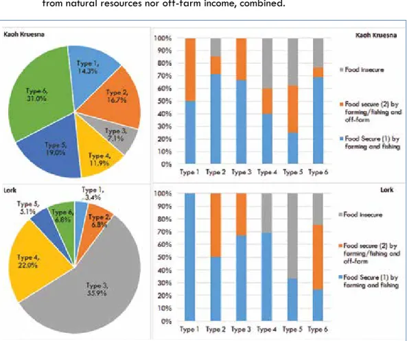
Household typology and food security
In order to capture the diversity of production activities at household level, we established a typology based on different production activities in which households are engaged. We considered three elements that established differences among households in the way their production system was functioning: involvement in farming; in fishing; and in self-employed non-farm activities. This led us to classify the households into six types, each offering a specific association of production activities. For instance: type 1 includes households who combine farming and fishing along with self-employed non-farm activities; type 2 are those who fish, farm but are not involved in self-employed non-farm activities; type 3 farm and are involved in self-employed non-farm activities but do not fish; type 4 are exclusively farmers; type 5 fish and are involved in self-employed non-farm activities; and type 6 are exclusively farmers. This typology is illustrated in Figure 3.
Involved in farming Land Landless Involved in fishing Fishing No fishing Fishing Involvement in
self-em-ployed non-farm activities Yes No Yes No Yes No Typology 1 2 3 4 5 6
Proportion in sample 7% 11% 36% 18% 11% 17%
Most of the households combine several activities but few have a fully diversified livelihood portfolio. Only 7 percent of the total sample were involved in a fully diversified scheme (type 1, farming, fishing and self-employed activities). This suggests that access to livelihood diversification is fragmented; people are restricted in their choice to diversify livelihoods because this depends on their labor capacity, their access to land and networks, and the skills and history of their family (Campbell et al. 2005).
The distribution of the different types of production system in each of the communities reveals important differences between both villages (Figure 4). To add clarity to these differences, we assessed the household food security status as the capacity of the household to ensure sufficient food consumption throughout the year:
• Food secure (level 1): households are secure with natural resources (farming and/ or fishing). Households in this category might be involved in off-farm activities as well
• Food secure (level 2): households are not food secure with natural resources (farming and/or fishing) to which they have access, but have access to enough off-farm resources to be food secure
• Food insecure: this category comprises household who are not food secure – neither from natural resources nor off-farm income, combined.
Sec
ti
on
D
Households in Kaoh Kruesna comprise a more diversified distribution of livelihood types but with a much higher percentage of landless fishers (31 percent). In Kaoh Kruesna, households involved solely in subsistence farming are the most insecure. This shows that a combination of natural resources and income from off-farm employment (self-employed or wage labor) offers the most food secure strategy to households. But we do see that 70 percent of households in Kaoh Kruesna who are involved solely in fishing are able to be food secure (type 6) as they have invested in fishing technology, capacity and in their Community Fishery to be effective in conservation and management.
In Lork, the incidence of landlessness is limited as most households (88.1 percent) have an agricultural land holding. Only 22 percent of households are engaged in fishing (types 1, 2, 5 and 6) (7 percent marine and 15 percent intertidal including 2 percent in both). In general, households in Lork rely more on cropping and self-employed non-farm/farm labor (type 3). A significant 64 percent of household are engaged in self-employed non-farm activities, mostly related to trade as Lork village center is a trading crossroad for the commune (Figure 2). In terms of food security, fishing households with no access to land (types 5 and 6) or engaged only in farming activities (type 4) are the most food insecure (Figure 4).
In order to cope with food insecurity, households have adopted a range of different responses, which were reflected in the household survey. Borrowing money is the first way in which respondents endeavor to cope, and borrowing food is the second.
Trends in adaptation to social-ecological changes
Social-ecological changes at play in the study area are quite similar in both communities: these include the degradation in fisheries resources/decline in fish catch per unit effort in an institutional context of weak governance (in both marine and intertidal zones) and the decline in the extent of farmland per household that takes place in a context where intensification and diversification in cropping systems is quite limited. At household level, we have identified three paths that households adopt most actively to adapt to these changes.
Enhancing farming or fishing activities
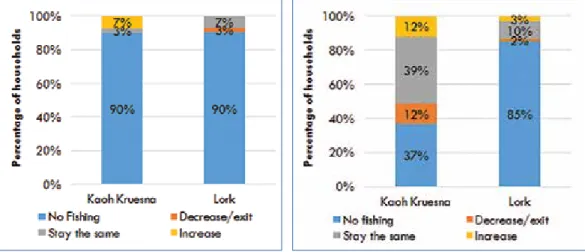
The first way households adapt to these changes is by investing further in activities related to the existing resource base (farming, intertidal and marine fishing). We have measured this intensification in terms of an increase in fishing or farming equipment and fish catch or rice yield per household. As indicated in Figures 5, 6 and 7, only a very limited proportion of households have opted for enhancing farming or fishing activities. In Kaoh Kruesna, 7, 12 and 4.9 percent of households have enhanced their marine zone fishing, intertidal fishing and farming activities, respectively, and 0 (zero), 3 and 13.8 percent in Lork.
Figure 7: Evolution of farming activities over the past 15 years
A similar proportion of households are involved in marine fishing in both village (10 percent) but in Kaoh Kruesna only, some of them have increased their fishing efforts in the marine zone (7 percent). These are the households who have upgraded their rowing boats to small-scale motorboats to quit fishing activities in the intertidal zone to engage in crab fishing around offshore islands (Case study 1). In Lork, 7 percent have maintained their fishing efforts in the deep-sea marine zone.
Figure 5: Evolution of fishing efforts in the
marine zone over the past 15 years
Figure 6: Evolution of fishing efforts in the
intertidal zone over the past 15 years
Case study 1: Moving from the intertidal zone into the marine zone to catch crab
Mr. Houn Soun, who is 30 years old, is a medium-scale fisher from in Lork village. In the past, he used a rowing boat for catching crab in the intertidal zone close to his village. On average he could catch 10 kg a day. Later, crab yield dropped, a decline which he understood to be the result of the destruction of mangrove forest and the increase in the number of fishers. In 2010, he purchased a new fishing vessel and switched to the marine zone because it was easier for him to catch crab here than in the intertidal zone.
Sec
ti
on
D
As far as intertidal zone fishing is concerned, the trend is slightly different. In Kaoh Kruesna, some households (12 percent) have intensified their fishing efforts, thereby putting more pressure on resources. Others (in the same proportion) have decreased their efforts or re-located them to the marine zone. A typical example is described in Case study 1. In the majority of cases, however, households have not changed the intensity of their fishing efforts. In Lork, a small number of households have increased fishing efforts in the intertidal zone, mostly through a shift from the marine zone. Most households fishing in the intertidal zone have maintained their efforts.
In the farming sector, given the difficulty of intensifying or diversifying agricultural production, the proportion of households who have invested in the enhancement of their agricultural production is limited, and is even lower in Kaoh Kruesna (5 percent) than it is in Lork (14 percent) where the agriculture-enhancing process has gained pace through land purchase and intensification of production to increase rice yield. In five cases, an enhancement of agriculture activities had been achieved by households who had abandoned fishing in the marine zone and been able to invest in land with the capital coming from the sale of their boats.
Moving away from both the land and the sea
A more important trend in adaptation to the changes in the resource system is the choice by some households to engage more in off-farm work. Two trends must be clearly differentiated here: the investment in self-employed non-farm activities and the increase in wage labor sometimes associated with migration (Figures 8, 9 and 10).
Figure 8: Evolution of self-employed non-farm
activities over the past 15 years
Figure 9: Evolution of local wage labor
Figure 10: Evolution of migration-related wage
labor activities over the past 15 years
Self-employed non-farm or non-fishing activities (typically relating to business/trade) are clearly on the rise. The trend is less significant in Kaoh Kruesna (17 percent) than it is in Lork (28 percent) and the underlying reason for these differences is that Lork is a trade center with many more opportunities than Kaoh Kruesna. The most profitable trade activities involve exchanges with Vietnamese traders (import/export) and we also noted many small-scale businesses linked to fishing (fish processing and transport, the sale of fishing equipment, and so on).
Interestingly, we observed that the intensification of self-employed off-farm activities and the enhancement of land-based or fishing activities are processes that are almost mutually exclusive. Only 2 percent of the whole sample had been engaged in both processes. Both require resources that only a few people can afford. Actually, the process through which the development of self-employed off-farm activities happens involves a reallocation of resources (labor and capital) away from fishing into trade. It builds on networks that have already been established with local traders and fishers. In both villages, households involved in these types of self-employed trade-related activities tend to have abandoned fishing in the marine zone for reasons explained earlier (an example also appears in Case study 2 below). This reallocation of resources requires a lot of upfront investment capital and leads to profitable trading activities. So this path of action was more successful for those households who had a higher endowment in fishing equipment and boats.
Another significant trend is the increase in wage labor activities (local or migration-related) usually in the non-farm and non-fishing sectors. Even though this trend marks a move away from land and natural resources, it does not engage the famers in re-investing or re-allocating the related equipment. The driving element is quite different as migration is more of a coping mechanism resulting from a low capacity to deal with change. To some extent, it even implies a process of de-capitalization (selling fishing equipment).
Sec
ti
on
D
Going into debt
A significant aspect of the current transformation in these coastal social-ecological systems is the increase in credit uptake. The survey indicated that a substantial 47 percent of households in Kaoh Kruesna and 74 percent in Lork accessed credit through either formal or informal institutions (or a mixture of both) and most of them had an outstanding debt. Credit took place through seasonal (cyclic) movement of borrowing and reimbursing, which mirrors the rhythm in the lives of a large majority of households in the two villages.
In addition to short-term borrowing at high interest rates to tackle food insecurity, credit is also use for productive investment mainly for farming (purchase of inputs such as fertilizers, seeds, and so on) and fishing (purchase of nets and traps, maintenance of boats and suchlike).
Fishing activities account for a large proportion of credit accessed in Kaoh Kruesna because this village relies heavily on fishing. The money is used for vessels or gear. On average, each household borrows USD 453, annually, for fishing and USD 125 for farming equipment and inputs. In Lork, households borrow money to support both farming and fishing activity. On average each household borrows USD 250, annually, to invest in fishing and USD 127 for farming.
Our results showed that, in addition to a high reliance on credit, going into debt has actually increased (31 percent of households in Kaoh Kruesna and 17 percent in Lork (Figure 11)). The main reason for this trend is the decline in the productivity of resources: households have to invest more in production inputs to maintain the same level of productivity or fish catch. Thus, when interest rates are high and the fishing season is poor, this adaptation has the potential to cripple them.
Case study 2: Abandoning large-scale fishing
Mr Dearv Sungheng, who is 52 years old, is a large-scale fisher from Lork village. He has been fishing for 30 years. In the past, he could secure a high income from his fishing activities, catching from 30 to 40 kg/day using traditional fishing gear. Recently he decided to abandon fishing because he could no longer benefit from this activity because of the decline in the fish catch that he associated with the presence of Vietnamese fishers in the Cambodian marine fishing zone. He argues that marine zone fishers use hi-tech and illegal fishing gear against which it is difficult to compete and that there is limited patrolling and law enforcement from relevant authorities. Another fisher living in Lork village, who requested to remain anonymous, told us that Mr. Deary Sunheang decided to abandon fishing because he had to pay too much money in ‘unofficial payments’ to authorities to be allowed to fish.
Figure 11: Evolution of credit uptake over the past 15 years
Adaptation and livelihood changes
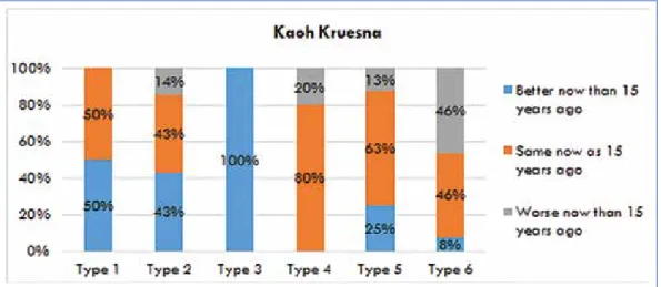
As a further point of investigation, we looked at the adaptive measures different types of households had adopted, and assessed how these had contributed (or not) to improving the food security situation of each. Figures 12 and 13 indicate how the food security status of households has changed over the past 15 years for the six different types.
In Kaoh Kruesna, 29 percent have improved their food security situation, 50 percent have maintained a status quo while, for 21 percent, the situation has worsened. In Lork, these percentages are 39 (more food secure), 47 (the same) and 14 (less food secure). Types 1 and 3 are mostly improving their situation (above the average in both villages) whereas, for types 5 and 6, the situation has worsened (below the average in both villages).
Figure 12: Evolution of food security status over the past 15 years for the six different types
Sec
ti
on
D
Figure 13: Evolution of food security status over the past 15 years for the six different types
of households in Lork
The mobility of households - overall and within each type - is highly significant. However, we suggest that there are three main trends underlying these movements:
• A relatively higher proportion of households in types 5 and 6 are suffering from a worsening food security status, and those are the households who rely most on fishing. This is a consequence of degradation in the fisheries resources system. They are clearly the most vulnerable section of the population in our study area and those who are most in need of support;
• As indicated above, a very small number of households had been able to enhance their existing land and natural resource activities. The other most successful measures to improve livelihood and food security status involved self-employed off-farm activity related to trade and business. But those with the capacity to make these non-farm investments were already among the families who were better off. • The effect of wage labor on the overall food security status of the households is
very limited. It works more as a coping mechanism and, alone, does not offer a solid path out of poverty.
CONCLUSION
The livelihoods options in these Cambodian coastal communities, and indeed in other resource dependent communities around the world, are now directly determined or affected by the interaction between the condition of the natural resource stock and the mobility into and out of other livelihood options such as wage or in-kind labor, entrepreneurship or cross border trade. These shifts are a direct result of the proliferation of close global-local links as products (or impacts) of globalization.
In our study area, this increased interest in off-farm and off-fishing labor opportunities results from a mix of push and pull factors. The push factors relate to the degradation of fisheries resources and the decline in fish catch available to individual fishers. This results mostly from weakness in the institutions responsible for governing the management of natural resources and is primarily manifested in ineffective control of illegal and over-fishing in the marine area and ineffective community-based fisheries management. The pull factors relate to the increase in opportunity for trade and business activities with Vietnam.
Increasing mobility is a central element in adaptation strategy and is manifested through mobility away from the resources. This includes mobility of labor (to non-farm, wage and migration related activity), the mobility of capital (de-capitalization from fishing and reinvestment in self-employed small trade activity), and mobility of landownership (occurring through market-based land concentration). This study from coastal Cambodia shows how livelihood improvement is related to the proximity of people to business or wage labor opportunities, or to trade with Vietnam. This increasing mobility has been sparked by the implementation of the economic and rural development policies of the government and its supporters whose aim is to produce more resource product (such as rice, fish and crops) with fewer producers.
However, the processes of adaptation in these communities have actually reinforced the wealth disparity between households. The increased mobility of labor through local and migration-related trade has reinforced the vulnerability of some households.
In this context, what could be done as we move forward? As an overall principle, we recommend a reinforcement of the activities and assets that are rooted in the people’s own resource systems. There are several paths through which this can be achieved. Given the key importance of land in buffering the degradation of fisheries resources, we recommend consolidating farming systems with small-scale and affordable irrigation systems, selecting the varieties of rice that are best adapted to the specific conditions of soils in coastal areas, and promoting the diversification of cropping systems by supporting production but also by enhancing fair access to inputs and markets. On the fisheries side, local communities need to be politically enabled and supported with both human and financial resources to undertake strong conservation and management. The intertidal fishing zone is an essential resource for the poorest. This strengthening of both conservation and management can be done through a revised CFi structure, or by the people themselves through deliberative and collective action, so that fishing at any scale can be maintained as part of a viable livelihood portfolio. For small-scale coastal fishing in Cambodia to be sustainable, and for the related communities to be food secure, a combination of individual and household investments is also required. The challenges that face the marine zone are largely beyond the control of local communities but a more strict implementation of the MoU between Kampot and Kie Giang in trans-boundary water management, particularly as it relates to fishing in Cambodian waters, would reduce illegal fishing and local corruption that tend to exclude fisherfolk from their own resource systems.
Sec
ti
on
D
ACKNOWLEDGMENTS
This research was funded by International Development Research Centre (IDRC) of Canada and implemented by the Learning Institute. The authors are grateful to Mr. Kob Math, former research officer, for sharing his documents and thoughts about the project with us. We are grateful to students from the Royal University of Phnom Penh and the Royal University of Agriculture who conducted field data collection, first and second rounds of the household survey and in-depth interviews: namely Mr. Cheng Oudom, Mr. Khim Satha, Mr. Suos Sotheata, Mr. Heng Chanta, Mr. Houth Theary, Ms. Srey Rachana, Mr. Teth Sopheak, Mr. Tean Seng Cheang, Ms. Vong Danet, Ms. Sang Zangta, Ms. Uk Sophanna, Ms. Mann Bopha, Ms. Kheng Kimly, Ms. Ban Thannita, Mr. Ben Rot, Mr. Soeung Yita, Ms. Proeung Tola and Ms. Liv Molika The field research was facilitated with support from Mr. Kiev Sat who is the head of the Community Fishery in Kaoh Kruesna and Mr. Lan Samorn who is head of the Community Fishery in Lork.
We have also have benefited from comments made by Mr. Ron Jones at the end of the research process and from Dr. Jan Taylor who succeeded in the difficult task of editing the final draft.
BIBLIOGRAPHY
Alongi, D. M. (2002) Present state and future of the world’s mangrove forest. Environmental
Conservation, 29(3), pp. 331-349.
Anonymous (2008) Memorandum of Agreement on the Policy and framework for
cooperation in management of coastal ecosystems and natural reosurces between the provinces of Kien Giang (Vietna) and Kampot (Cambodia).
Bernstein, H. (2010) Class Dynamics of Agrarian Change: Writing a ‘Little Book on a
Big Idea’. Agrarian Studies Colloquium. New Haven.
Brugère, C., Holvoet, K. and Allison, E. H. (2008) Livelihood diversification in coastal and
inland fishing communities: misconceptions, evidence and implications for fisheries management., Sustainable Fisheries Livelihoods Programme Working Paper Rome:
FAO/DFID.
Campbell, J., Townsley, P., Whittingham, E., Ward, A., Sem, V., Sim, B., Heng, P., Em, D., Nut, L., Phork, P., Chhun, S., Chap, S., King, S., Iem, M., So, S. and Nith, C. (2005)
Understanding the factors that support or inhibit livelihood diversifcation in coastal Cambodia. Phnom Penh: IMM LTD, Fisheroes Administration, CBNRM Learning
Institute and FAO.
Cock, A. (2010) Anticipating an Oil Boom: The ‘Resource Curse’ Thesis in the Play of Cambodian Politics. Pacific Affairs, 83(3), pp. 525-546.
Degens, P. and Choun, D. (2007) Impact Assessment of the NRM component. GTZ Rural
Development Program Kampot/Kampong Thom. Phnom Penh.
Department Fisheries (2005) Annual Fisheries Statistics of Cambodia in 2004. Phnom Penh: Ministry of Agriculture, Foresty and Fisheries.
Duke, N. C. (1992) Mangrove Floristics and Biogeography. in Robertson, A. I. and Alongi, D. M., (eds.) Tropical Mangrove Ecosystem, Washington D.C.: American
Geophysical Union. pp. 63-100.
Em, P. (2007) Marine Fisheries Resource Management Potential for Mackerel Fisheries of
Cambodia. Unpublished Research Report, The United University, Reykjavik, Iceland.
Ewel, K. C., Twilley, R. R. and Ong, J. E. (1998) Different kinds of mangrove forests provide different goods and services. Global Ecology and Biogeography, 7(1), pp. 83-94. Farnsworth, E. J. and Ellison, A. M. (1997) The global conservation status of mangroves.
Sec
ti
on
D
Food and Agricultural Organization (2005) Global Frest Resources Assessment: thematic
study of mangroves in Cambodia, Roma: Forest Service Division, FAO.
Gillett, R. (2004) The marine fisheries of Cambodia. FAO/FishCode Review - FCR04 Phnom Penh.
Granek, E. F., Polasky, S., Kappel, C. V., Reed, D. J., Stoms, D. M., Koch, E. W. and Wolanski, E. (2010) Ecosystem Services as a Common Language for Coastal Ecosystem-Based Management. Conservation Biology, 24(1), pp. 207-2016.
Israel, G. D. (1992) Determining Sample Size. Fact Sheet PEOD-6: University of Florida. IUCN (2013) Building Resilince to Climate Chamge Impacts; Coastal Southeast Asia, Kampot
Province. Kampot: IUCN.
Johnsen, S. and Munford, G. (2012) Country Environment Profile: Royal Kingdom of
Cambodia. Phnom Penh: European Union.
Kirkman, H. and Kirkman, J. A. (2002) The Management of Seagrasses in Southeast Asia.
Bulletin of Marine Science, 71(3), pp. 1379-1390.
Le Billon, P. (2000) The Political Ecology of Transition in Cambodia 1989-1999: War, Peace and Forest Exploitation. Development and Change, 31, pp. 785-805.
Marschke, M. (2012) Life, Fish and Mangroves. Resource governance in coastal Cambodia, Ottawa: University of Ottawa Press.
MoE and DANIDA (2002) Physical Framework Plan Koh Kong Province. Phnom Penh. Monyneath, V. (2000) The Status of Cambdodia’s Coastal and Marine Environment:
“Emerging Policies and Management Strategies” in Paper Presented to the International Symposium on Protection and Management of Coastal Marine Ecosystem.
Mumby, P. J., Edwards, A. J., Arias-Gonzalez, J. E., Lindeman, K. C. and Blackwell, P. G. (2004) Mangroves enhance the biomass of coral reef fish communities in the Caribbean. Nature, 427(6974), pp. 533-536.
NACA (2004) STREAM: Support to Regional Aquatic Resources Management System
Requirement Report. Phnom Penh: Fisheries Department.
National Institute of Statistics (2013) Cambodia Inter-Censal Population Survey 2013, Phnom Penh: Ministry of Planning.
NCDD (2012) Commune Database Online. Available at: http://www.ncdd.gov.kh Newkirk, G. (1996) Sustainable coastal production systems: a model for integrating
aquaculture and fisheries under community management. Ocean & coastal
management, 32(2), pp. 69-83.
Orth, R. J., Carruthers, T. J. B., Dennison, W. C., Duarte, C. M., Fourquean, J. W., Heck, K. L. and Hughes, A. R. (2006) A global crisis for seagrass ecosystems. BioScience, 56(12), pp. 987-996.
Ouk, V., Prak, V. and Rafae, B. (2012) Coastal Fisheries Management in Cambodia, with
Case Study in Preah Sihanouk Province. Quezon City: Partnerships in Environmental
Management for the Seas of East Asia (PEMSEA).
Rizvi, A. R. and Singer, U. (2011) Coastal Situational Analysis. Gland: IUCN. Royal Government of Cambodia (2006) Law of Fisheries, NS/RKM/0406/011.
So, N. and Touch, B. (2011) Fishery Resources in Cambodia: Implications for Food Security, Phnom Penh: Inland Fisheries Research and Development Institute (IFReDI).
Turner, R. K., Adger, N. W., Crooks, S., Lorenzoni, I. and Ledoux, L. (1999) Sustainable coastal resources management: principles and practices. Natural Resources Forum,
23, pp. 275-286.
Un, K. and So, S. (2009) Politics of Natural Resource Use in Cambodia. Asian Affairs: An
American Review, 36(3), pp. 123-138.
Unsworth, R. K. (2014) Seagrass meadows in a globally changing environement. Marine
Pollution Bulletin, 83, pp. 383-386.
Unsworth, R. K. and Cullen, L. C. (2010) Recognising the necessity for Indo-Pacifi seagrass conservation. Conservation Letters, 3(2), pp. 63-73.