HAL Id: hal-00276833
https://hal.archives-ouvertes.fr/hal-00276833
Submitted on 2 May 2008
HAL is a multi-disciplinary open access
archive for the deposit and dissemination of
sci-entific research documents, whether they are
pub-lished or not. The documents may come from
teaching and research institutions in France or
abroad, or from public or private research centers.
L’archive ouverte pluridisciplinaire HAL, est
destinée au dépôt et à la diffusion de documents
scientifiques de niveau recherche, publiés ou non,
émanant des établissements d’enseignement et de
recherche français ou étrangers, des laboratoires
publics ou privés.
DATABASE TO MANAGE LANDSLIDES WITH GIS
IN MOUNTAINOUS ENVIRONMENT
Yannick Thiery, Anne Puissant, Jean-Philippe Malet, Alexandre Remaitre,
Elise Beck, Simone Sterlacchini, Olivier Maquaire
To cite this version:
Yannick Thiery, Anne Puissant, Jean-Philippe Malet, Alexandre Remaitre, Elise Beck, et al..
TO-WARDS THE CONSTRUCTION OF A SPATIAL DATABASE TO MANAGE LANDSLIDES WITH
GIS IN MOUNTAINOUS ENVIRONMENT. 6th AGILE Conference on GIScience, Apr 2003, Lyon,
France. 10 p. �hal-00276833�
Proceedings of the 6
thAGILE
April 24
th-26
th, 2003 – Lyon, France
TOWARDS THE CONSTRUCTION OF A SPATIAL DATABASE TO
MANAGE LANDSLIDES WITH GIS IN MOUNTAINOUS
ENVIRONMENT
Thiery Y.1, Puissant A.2, Malet J.-P.1, Remaitre A.1, Beck E.2, Sterlacchini S.3, Maquaire O.1
1 Institut de Physique du Globe, UMR 7516 CNRS/ULP, 5, rue Descartes, 67084 Strasbourg, France. 2 Image et Ville, UMR 7011 CNRS/ULP, 3, rue de l’Argonne, 67000 Strasbourg, France. 3 Department of , Universita degli studi di Milano-Bicocca, Piazza della Scienza, 120126 Milano,
Italy
1. INTRODUCTION
Geographic Information Systems (GIS) are more and more used for the management
and the prevention of risks, either natural or man-made. Most of these studies concern flood risk mapping [1] and earthquake susceptibility assessment [2]. During the last ten years, most progress has been also accomplished for landslide susceptibility assessment, at both medium (1:25.000) and large (1:10.000) scales. At these scales, three types of methods exist to locate and characterize the landslide-prone areas (ie., that gather the ground conditions favourable to slope instabilities) [3], [4], [5]:
• the qualitative approach, based on expert knowledge [6];
• the deterministic approach, taking into account geotechnical data to calculate a safety factor of the hillslopes [7], used for very large scale (1/5.000, and less);
• the statistical approach (bivariate, multivariate), used for coarser scales [3], [8],
The underlying concept of these GIS-based (raster) methods is the "terrain unit", or “homogeneous unit” (ie., the pixel) which is defined as the portion of land surface which contains a set of ground conditions which differ from the adjacent units across definable boundaries [9]. With the statistical approach, the objective is to forecast the occurrence in space of a landslide on the basis of the values of a set of variables or factors. The aim is to predict the behaviour of a dependent variable (landslide susceptibility) on the basis of a set of known independent variables (ground conditions). The final result is an estimate of a spatial correlation between the landslide distribution and each ground conditions. Several statistical methods have been developed (multivariate analysis, conditional analysis, weight of evidence analysis). A comprehensive review can be found in [4].
By definition, as the simulations are dependent on the quality of the input data (map scale, typology, precision), it is necessary to evaluate the propagation errors and to define a set of information sources adapted with the quality expected for the final results. The terrain-unit comprises five categories of input dataset [4]: the geomorphology (landslides), the topography (elevation, slope angle, slope aspect,) the geology (lithology, structure, superficial deposits), the land-use (human activities, vegetation, infrastructures), and the hydrology (hydrographic network, swamps). Moreover, the terrain-unit must be mappable at effective cost over the entire region through criteria which are as objective as possible. Recent studies have shown that the use of a similar data acquisition technique (analysis of aerial photography) by different experts can lead to distinct results. For, instance, Van Carrara et al. [3] and Westen et al. [10] observed respectively 75% and 78% of difference in the location of landslides, carried out by distinct persons on different areas. The expert knowledge of the scientist and the type of data acquisition influence the final results.
2. POSITION OF THE PROBLEM AND OBJECTIVES
While different GIS-based statistical algorithms of landslide predictive modeling exist, few studies explain (i) the best way to acquire the input data and (ii) the overall influence of the input datasets on the quality of the output results. For most of the studies, the main sources of information are aerial photographs and topographic maps. As the analysis of these documents is often delicate especially for the recognition of the unstable zones (shadow, morphology hidden by vegetation), a field verification (somehow costly) is essential. One other difficulty stands in the integration of data that have different origins (image data, field observations, technical reports, eg.) and unequal precision. Even though Soeters and Van Westen [4] have proposed a roadmap defining the best source documents to integrate in the database (according to the working scale), neither any sound evaluation of the source information, nor any assessment of the acquisition exist. A methodological reflexion has to be carried out to define the best source of information according to the objectives of the study, the scale of interest, the complexity of the environment (topography, land-use) and the time available.
The study area is situated in the Barcelonnette basin (South French Alps). This basin
extends over 200 km2, with moderate size (22 km long, and 10 km wide). The Ubaye river
drains the basin, which slopes from 1100 to 3100 m. Surrounding crests are capped by two massive sheet thrusts, made up of limestone, sandstone and flysch. Lower slopes are underlain by less resistant callovo-oxfordian black marls, which are locally covered by
morainic deposits. Geomorphological forms comprise very steep (>65%) naked badlands
areas, regular slopes and hummocky topography due to heterogeneous accumulations zones. Various factors including lithology, tectonics, climate and the evolving land use have given rise to numerous slope movements like rotational landslides, earthflows or debris flows. The behaviour of these slope instabilities have been studied during the last ten years by several research teams [11], [12]. Based on this knowledge, the objective is to locate and predict spatially their favourable topographical, geological and geomorphological conditions. In this context, a spatial database of ground conditions inducing landslides was built at a 1/10.000 scale. Several datasets, obtained by different ways (national or regional database products, more or less complex user-oriented databases) were tested to define which is the optimal source of information that would guaranty the statistical modeling the closest to reality. The susceptibility maps obtained with the different datasets were compared to a reference morphological map, produced by the expert method.
3. INPUT DATA AND METHOD
The landslide susceptibility maps were built through the statistical computation of the nine ground conditions factors (also called factors of predisposition) proposed by Soeters and Van Westen [4]. The input data have different origins (freely available or commercial existing national databases, aerial photographs, satellite imageries, paper maps, field observations, technical reports) and different formats (data in raster format; data in vector format, data requiring a procedure of digitization before rasterization).
3.1. Data in raster format
The required data can be still available (public sources), on the countrary a specific processing must be undertaken. The available information are usually provided by geographical institute of each country (in France, l’Institut Geographique National). First step consist to check if the set of data (national height information database, national land use product, aerial photographs, orthophotomaps) is adapted for the study.
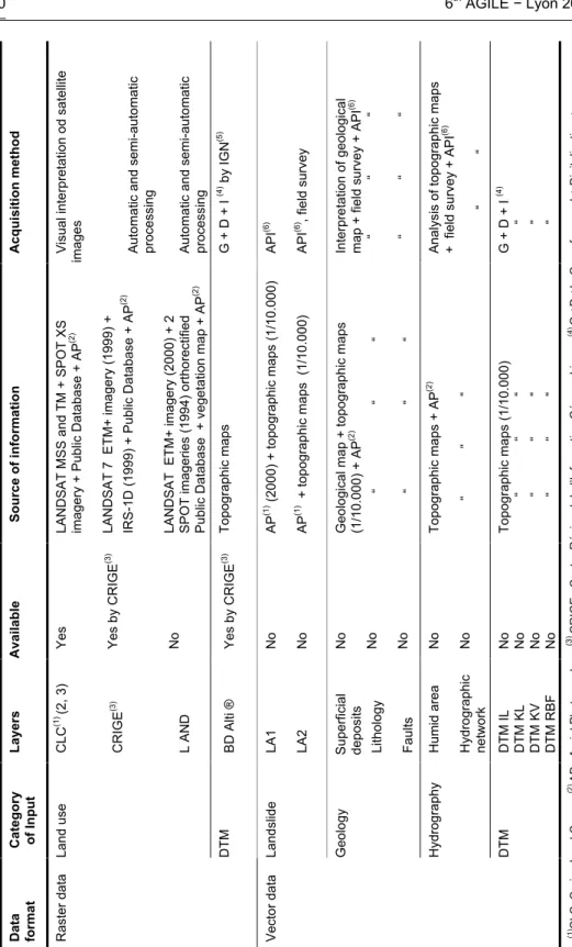
6th AGILE − Lyon 2003 40 Acqui sitio n m et hod Visual inter pr etation od satellite
images Automatic and semi-automatic processing Automatic and semi-automatic processing G
+ D + I (4 ) by I G N (5 ) API (6 ) API (6 ) , field surve y Interpre tation of geological
map + field survey + API
(6 ) “ “ “ “ “ “
Analysis of topographic maps + field survey +
API (6 ) “ “ G + D + I (4 ) “ “ “ Source of i n fo rmatio n LANDSAT MSS and TM + SP OT XS
imagery + Public Database + AP
(2 ) LANDSAT 7 E T M+ imagery (199 9) + IRS-1D (1999 ) + Public Database + AP (2 ) LANDSAT ETM + imagery (2000 ) + 2 SPOT image ries (1994) ortho rectified
Public Database + vegetation map + AP
(2 ) Topogr aphic maps AP (1 ) (2000) + to pographic maps (1/10.000 ) AP (1 ) + topograp hic maps (1/10.0 00)
Geological map + topographic m
aps (1/10.000 ) + AP (2 ) “ “ “ “ “ “ Topogr aphic maps + AP (2 ) “ “ “ Topogr aphic maps (1/10.000 ) “ “ “ “ “ “ “ “ “ Available
Yes Yes by CRIGE
(3 ) No Yes by CRIGE (3 ) No No No No No No No No No No No Layers CLC (1 ) (2, 3) CRIGE (3 )
L AND BD Alti ® LA1 LA2
Superficial deposits Lithology Faults Humid area Hydrogra
phic network DTM IL DTM KL DTM KV DTM RBF Categ o ry of In pu t
Land use DTM Landslide Geology Hydrogra
phy
DTM
Data forma
t
Raster data Vector data (1) CL
C: Corine Lan d Cove r ; (2 ) AP : Ae rial Pho togr aphs ; (3 ) CRIGE : Cen tre Régiona l de l’ Info rm ation Géograp hiq ue ; (4) G + D +I : Ge oreferen ced + Digi taliza tion + Inte rp ola tion ; ; (5IG N : In stitu t Na tional Géo gra phi que ; (6) API : Aerial Pho to gra ph Inter pre tati on
For this study, available data in raster format were: (1) for the elevation, the BDAlti® (DTM with a spatial resolution of 30m), (2) for the land cover, the Corine Land Cover database (CLC, gathered by the European Union) and the landcover Database of the Provence Alpes Côte d’Azur Region (processed by the Comité Régional de l’Information Géographique, CRIGE). The CLC comprises 3 levels but only two of them were used: (i) the level 2 (divided in 11 classes), and (ii) the level 3 (divided in 19 classes). The final product is drawn at the scale of 1/100.000 with a spatial resolution of 250 m. The CRIGE database is made up of 14 classes representing the land cover of the Provence Alpes Côte d’Azur region (Table 3). The final product is drawn at the scale of 1/50.000 with a spatial resolution of 30 m. Faced with the lack of land cover database drawn at the scale of 1/10 000, such a database (divided in 14 classes of land cover) has been established by combining a Landsat ETM+ image (spatial resolution of 30 m) and a Spot Panchromatique image (spatial resolution of 10 m). The combination must take into account the specific characteristics of the study area.
3.2. Data in vector format 3.2.1. Polygon data
Any national database does not exist. The database has to be produced by a specific way (slope movements limits, geological limits, and extension of wetted areas (Table 1). In order to correctly delineate these limits, two investigation method can be used: (i) by combining an aerial photographs interpretation and a careful map study, and (ii) by combining an aerial photographs interpretation, a careful map study and a detailed field description which is usually not easy. This case is illustrated through the example of the “ground movement” database (Table 1: LA1, database established with the help of several aerial photographs taken in 2000; LA2, same database as LA1 completed by additional field data).
3.2.2. Point/line data
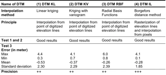
According to the complex topography of the study area, a height elevation database with a good accuracy has to be established. Hence, the elevation contours have been digitalized. Some enlarged (1/10 000) topographic map drawn at the scale of 1/25 000 have been used for this job. The dense grid coordinates gathered with the digitization were used in order to produce a DTM with a high spatial accuracy (resolution of 10 m). Four interpolation methods, adapted for irregular grid, were tested : (1) the linear kriging method [13], [14] ; (2) the anisotropic kriging method (with integration of a variogram) [13], [14], (3) the radial basis function method [14], and (4) the “Borgefors distance method” [15]. Numerical interpolations were performed by using Surfer and Ilwis softwares.
3.3. Calculation of susceptibility map: the Weight of Evidence method
The landslide susceptibility map has been drawn according the bayesian « weight of evidence » method proposed by [16] for gold layer and adapted by Sterlacchini [17] for ground movements. Model were based on following assumptions [3] : (i) future landslides will take place under same circumstances that in past, (ii) all conditioning factors are know and included in the model, (iii) all past and present landslides have been identified in the study area.
The Weight of Evidence modelling technique is the log-linear version of the general bayesian theorem which uses a probability framework, based on the idea of prior and posterior probability, to solve the problem of combining multiple data sets. The prior probability is the probability that a terrain unit contains the response variable (the landslides) before considering the existing predictor variables (the favourable ground conditions factors). This model is fundamentally based on the calculation of positive and negative
weights (W+ and W-), the magnitude of which depends on the measured association
6th AGILE − Lyon 2003 42 ) D | B ( P ) D | B ( P ln W+ = − ) D | B ( P ) D | B ( P ln W −− − = −
where B is the class of the predictor variable and D is the response variable. The symbol “-“
represents the absence of the predictor and/or response variable. The model is expressed in an odds form (ratio of the probability that an event will occur to the probability that it will not occur) [16].
Being the model in a log-linear form, the weights can also be added. Therefore the
contrast C = W+ - W- gives an overall measure of the degree of spatial association between
the predictor variables and the response variable, in each precise geographic location. The contrast C has a null value when a predictor variable has a distribution which is spatially independent in relation to the response variable. So the contrast value is a first important basis for accepting (or rejecting) the evidence themes as predictor themes, evaluating the level of spatial correlation between a precise supporting variable and the response variable.
The calculation of the W+ and W
- values for all the selected predictor evidences allows
the calculation of the posterior probability, which updates (increases or decreases) the prior probability. When several predictor themes are combined, the areas with the greatest coincidence of low/high weights produce the lowest/greatest probability of occurrence of the response variable.
3.4. Susceptibility map and landslide map comparison
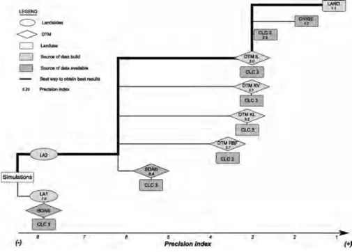
In order to increase the quality of the data set, several modelling process were tested with various data sets. Therefore, the calculation were performed by introducing successively data sets which required the hardest work and the highest pre-processing. Susceptibility maps and inventory maps were compared in order to evaluate the precision of each method. A precision index can be computed by dividing (i) the pixels of the susceptibility map which have the highest probability of ground movement occurrence and (ii) the pixels of the mapped ground movement spatial distribution. Best calculations are those which provide the weakest index.
Fig. 1 Flow-chart of the best way to obtain good results and precision index depending on the databases.
4. RESULTS
4.1. Influence of the method to produce the input landslide database
The precision index computed for the two susceptibility maps estimated with the two production methods of landslides database (LA1, LA2, Table 1), the DTM resulting from BDAlti®, and CLC landcover, have respectively a value of 7.9 and 6.4 (Fig 1). A better precision on the landslides boundaries with the field survey explains the relative improvement in precision with LA2. As the global percentage of "landslides" areas is decreased, the (very) particular combinations between the various factors are more specifically identified. For the database "landslides", the information brought by a simple photo-interpretation is not sufficient to assess susceptibility at a 1/10.000 scale. Nevertheless, if a complement of information is brought by field survey, this benefit remains relatively limited compared to the benefit on others databases.
4.2. Influence of the method to produce the input height elevation database 4.2.1. Evaluation of DTM precision
Before carrying out the simulations, several tests were performed to consider the relative precision of the four digitised and interpolated DTM. The BDAlti® was excluded from these tests (we consider that the IGN has validated it). The tests have consisted in: (i) identifying visually the interpolation errors; (ii) verifying if all the pixels included in a specific elevation class have a simulated elevation corresponding to this class [26], (iii) calculating elevation errors with ground control points (12 IGN points and 18 GPS points). Several artefacts were generated with the interpolation methods (1), (2) and (3), in particular in the flat zones (sink hole effects); the interpolation method (4) gives better results (Table 2).
4.2.2. Influence of DTM quality
Figure 1 shows the precision gained with the DTM produced by digitisation and interpolation of the elevation lines. The precision index decreases (from 6.4 with BDAlti® to 3.0 with the interpolated DTM). The precision benefit is significant (by two times). Therefore for large scale studies (1/10.000), the national height elevation database (resolution of 30m) is not adapted, in particular for complex mountainous environments. In this specific case, it is essential to have precise and adapted topographic information (metric resolution, and elevation precision close to the meter), built either by precise digitisation of elevation lines (time-consuming task), or derived from expensive technical image processing (photogrammetry, laser scanning).
Name of DTM (1) DTM KL (2) DTM KV (3) DTM RBF (4) DTM IL
Interpolation method
Linear kriging Kriging with variogram
Radial Basis Functions
Borgefors distance method
Principle Interpolation from
point of digitized elevation lines Interpolation from point of digitized elevation lines Interpolation from point of digitized elevation lines Rasterization of elevation lines and interpolation from pixels Test 1 and 2 Good results Good results Good results Good results Test 3
Error (in meter) Max Min Mean Standard deviation 4.4 0.3 -0.53 2.30 4.1 0.7 -0.37 2.29 6.0 0.8 -0.26 2.39 4.1 0.1 -0.28 1.85 Precision ++ ++ ++ +++
6th AGILE − Lyon 2003 44
4.3. Influence of the method to produce the landcover database (resolution and nomenclature)
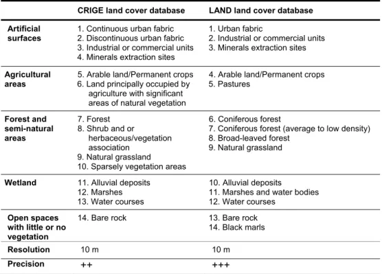
The best precision index is obtained with the landcover database (LAND) produced with satellite imageries. The precision index increases by two times with the use of the CLC3 landcover (2.5) to the LAND landcover (1.1). This benefit is due respectively (1) to the scale and the resolution to whom the databases were produced, and (2) to the typologies used. Both effects of resolution and working scale is identified with the precision indices associated with CLC3 and CLC2. Thus, the production scale of CLC (1/100.000) does not allow to identify unit terrain lower than 25 ha. Therefore, some landcover types, very specific to the location of landslides, are not taken into account by the model.
CRIGE land cover database LAND land cover database Artificial
surfaces 1. Continuous urban fabric 2. Discontinuous urban fabric 3. Industrial or commercial units 4. Minerals extraction sites
1. Urban fabric
2. Industrial or commercial units 3. Minerals extraction sites Agricultural
areas
5. Arable land/Permanent crops 6. Land principally occupied by
agriculture with significant areas of natural vegetation
4. Arable land/Permanent crops 5. Pastures Forest and semi-natural areas 7. Forest 8. Shrub and or herbaceous/vegetation association 9. Natural grassland
10. Sparsely vegetation areas
6. Coniferous forest
7. Coniferous forest (average to low density) 8. Broad-leaved forest
9. Natural grassland
Wetland 11. Alluvial deposits 12. Marshes 13. Water courses
10. Alluvial deposits
11. Marshes and water bodies 12. Water courses
Open spaces with little or no vegetation
14. Bare rock 13. Bare rock 14. Black marls
Resolution 10 m 10 m
Precision
++ +++
Table 3 Nomenclature of the CRIGE and LAND landcover databases; Precision: + low, ++ mean; +++ high
Moreover the influence of the nomenclature and the number of classes is pointed out by comparing the precision indices associated to the simulations using the CRIGE and LAND landcover (Fig. 1, Table 3). With the CRIGE landcover, 80% of the observed landslides are located in the class "forests”, whereas the LAND landcover allows a better discrimination (55% of the landslides are located in the class "conifer forests", 45% are located in the other classes of the topic "forests and semi-natural areas"). Therefore, the Weight of Evidence method interprets the class "forests" (CRIGE) like a class with strong landslide probability and thus over-estimates this class in simulations.
Thus, the various available databases are not adapted to the objectives. In the case of complex study areas, it is necessary to dispose of a precise landcover at a 1/10 000 scale. Moreover, the landcover nomenclature must be produced according to the particularities of the study area. This is particularly true for the topic "forests and semi-natural areas" (shrub and herbaceous vegetation association, types of meadows), gathered from the satellite imageries processing. Many authors have demonstrated that this type of statistical models is
very sensitive to the landcover database [18], [19], [20]. The definition of a landcover nomenclature adapted to landslides particularities is essential.
5. DISCUSSION/CONCLUSION
The results obtained during this analytical study show that the available (existing) databases are not adapted to the assessment of the ground conditions susceptibility to landslides at a 1/10 000 and for complex sites (topography, vegetation). It is necessary to adapt the databases to the site, in terms of spatial resolution, accuracy and nomenclature. If the specific characteristics of the site do not appear in the input data, the final results can be very biased.
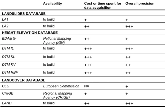
Availability Cost or time spent for data acquisition
Overall precision LANDSLIDES DATABASE
LA1 to build
+ +
LA2 to build
++ +++
HEIGHT ELEVATION DATABASE
BDAlti ® National Mapping
Agency (IGN)
++ +
DTM IL to build+++ +++
DTM KL to build+++ ++
DTM KV to build+++ ++
DTM RBF to build+++ ++
LANDCOVER DATABASE CLC European Commission NA+
CRIGE Regional Mapping
Agency (CRIGE)
+ +
LAND to build
++ +++
Table 4. Cost/Benefice ratio for the databases built up. NA : Not adapted ; +: low ; ++ :mean ; +++: high.
A classification of the "ground conditions" databases the most sensitive to simulations can be defined according to the benefit profit in term of precision index. The most sensitive database are respectively the height elevation database and the land cover database. The profit in term of precision index on the landslide database is weak between the two types of generation methods. This means that an accurate and oriented (expert) photo-interpretation is sufficient, even for complex study sites. In this case, the fieldwork is only useful to check the type of landslide or define it activity. The limits of the unstable zones are well defined by the analysis of the air photographs and the othophotoplans.
For the others databases, one can then wonder which are the best information sources and the best production methods to obtain an accurate minimal dataset allowing good simulations. In different terms, how can we optimize the ratio "cost/benefit" to produce these databases? Therefore, a “cost/benefit” ratio has been evaluated for the production of the three necessary databases. In all the cases, the specific databases created to improve the available databases improve significantly the precision index. The best combination of databases is LA2, DTM IL and LAND. These databases were built with high resolution aerial photographs of the study site, a Landsat ETM+ image, two SPOT P, and 1/10 000 scale topographic maps. These documents are the minimal datasets to acquire for susceptibility
6th AGILE − Lyon 2003 46
requires 3 to 4 months (digitalisation, image processing, incorporation of ancillary data, field observations, and tests of quality).
Fig. 2 Comparison between (1) orthophotomap with inventory of landslides, (2) susceptibility map obtained with LA1, CLC3 and BDAlti® ,
(3) susceptibility map obtained with LA2, LAND, DTM IL.
6. PERSPECTIVES
Nevertheless, the susceptibility maps obtained with the best databases are not fully satisfactory (Fig. 2). Indeed the landslides introduced into the model are simulated only partially. With the same databases as information source, it appears now essential to refine the simulations by distinguishing the types of landslides. As underlined by Atkinson and Massari [21] each type of landslide has its own factors of predisposition.
Acknowledgements
This research was supported by the European Union, through the research programme ALARM (Assessment of Landslide Risk and Mitigation in Mountains Area), contract EVG1-2001-00018, 2002-2004, Coordinator: S. Silvano (CNR-IRPI, Padova). Mr. J. Hirsch and Mr A. Bernard are gratefully
acknowledged for their help. The authors wish to thank the CRIGE-PACA to put the Corine Landcover, CRIGE Landcover and BDAlti® databases at our disposal.
7. BIBLIOGRAPHICAL REFERENCES
[1] Shanker K.S., Ab Ghani A., Mohd. Sanusi S. Ahmad, Nor Azazi Z. (2003), Flood risk mapping for Pari River incorporating sediment transport, Environmental Modelling & Software, 18, pp. 119–130. [2] Luzi l., Pergalini F., Terlien M.T.J. (2000), Slope vulnerability to earthquake at subregional scale,using probabilistic techniques and geographic information system, Engineering Geology, vol. 58, pp.313-336.
[3] Carrara A., Cardinali M., Guzzetti F., Reichenbach P. (1995), GIS technology in mapping landslide hazard in Carrara A., Guzetti F (eds,), Geographical Information Systems in Assessing Natural Hazards, pp.135-176.
[4] Soeters R., Van Westen C.S. (1996), Slope instability, recognition, analysis, and zonation, in Turner A.K., Schuster R.L. (eds), Landslides investigation and mitigation, Transport Research board, National Research Council, special report 247, pp.129-177.
[5] Aleotti P., Chowdhury R. (1999), Landslide hazard assessment: summary review and new perspectives, Bulletin of Engineering Geology Environnment, 58, pp. 21–44.
[6] Leroi, E., 1996. Landslide hazard-risk maps at different scales: Objectives, tools and developments. In: Senneset, K. (ed.), Landslides, vol. I, Balkema, Rotterdam, pp. 35-51.
[7] Wachal D. J. and Hudak P. F. (2000); Mapping landslide susceptibility in Travis County, Texas, USA, GeoJournal 51, pp. 245–253.
[8] Chung C.F., Fabbri A.G. (1993), The representation of geoscience information for data integration, Nonrenewable Resources, v.2:2, pp. 122-139.
[9} Hansen A. 194. Landslide hazard analysis. In Brunsden, D., Prior, D.B. (Eds.): Slope Instability, Wiley & Sons, New-York, 532-602.
[10] Van Westen C.J.,. Seijmonsbergen C., Mantovani F. (1999), Comparing landslide hazard maps, Natural Hazards 20, pp. 137–158.
[11] Flageollet J.-C., Maquaire O., Martin B., Weber D. (1999), Landslides and climatic conditions in the Barcelonnette and Vars basins Southern French Alps, France Geomorphology , 30, pp. 65–78.
[12] Maquaire O., Malet J.P., Remaître A., Locat J., Klotz S., Guillon J. (in press) Instability conditions of marly hillslopes : towards landsliding or gullying ? The case of the Barcelonnette basin, South-East France, Engineering Geology, (accepted), 19 pp.
[13] Surfer for Windows User's guide (1996), 3è éd., Golden Software Inc., pp. 619.
[14] Gratton Y (2002).,Le krigeage : la méthode optimale d’interpolation spatiale, Les articles de l’Institut d’Analyse Géographique, www.iag.asso.
[15] Carrara A., Bitelli G., Carla R. (1997), Comparison of techniques for generating digital terrain models from contour lines, International Journal of Geographical Information of Sciences, Vol 11, n°5, pp. 451-473.
[16] Bonham-Carter G.F., Agterberg F.P., Wright D.F. (1989), Weight of evidence modeling: a new approach to mapping mineral potential, Statistical Applications in the Earth Sciences, ed. F.P. Agterberg and Bonham-Carter GF., Geological Survey of Canada, Papaer89-9, pp. 171-183.
[17] Sterlacchini S. (2000), Applcazione di un modello previsionale di tipo bayesiano per la valutazione della pericolosità connessa a movimenti versante, Quaderni di Geologia applicata, 7-4, sup. 2, pp. 95-109.
[18] Thein, S., Schmanke, V., Grunert, J. 1995. The production of a landslide-susceptibility map at the scale of 1:10 000 for the Katzenlochbach- and Melb-Valley southwest of Bonn using a Geo-Information-System, Mitteilungen - Osterreischischen Geographischen Gesellschaft, 137, 97-104.
[19] Wilson, J.P., Gallant, J.C. 2000. Terrain Analysis: Principles and Applications. J. Wiley & Sons, New-York, 479 pp.
[20] Sánchez, M.J. 2002. Slope deposits in the Upper Nalón River Basin (NW Spain): an approach to a quantitative comparison, Geomorphology, 43(1-2), 165-178.
[21] Atkinson P.M., Massari R. (1998), Generalised linear modeling of susceptibility to landsliding in the Central Apennines, Italy, Computers and Geosciences, Vol. 24, n° 4, pp. 373-385.