T H E S M A R T P O I N T C L O U D
Structuring 3D intelligent point data
Florent Poux
UNIVERSITY OF LIÈGE Doctoral dissertation 2019
Université de Liège
T H E S M A R T P O I N T C L O U D
Structuring 3D intelligent point data
par Florent Poux
Département de Géographie Faculté des Sciences
Thèse présentée
en vue de l’obtention du grade de Docteur en Sciences Juin 2019
This dissertation is approved by the promotor: Prof. Dr. R. Billen Composition of the doctoral committee:
Prof. Dr Roland Billen University of Liège, Belgium Prof. Dr. Pierre Grussenmeyer INSA Strasbourg, France Prof. Dr. Pierre Hallot University of Liège, Belgium Prof. Dr. Fabio Remondino Foundation Bruno Kessler, Italy Composition of the Jury:
Prof. Dr. Pierre Hallot President (University of Liège, BE) Prof. Dr. Yves Cornet Secretary (University of Liège, BE) Prof. Dr. Roland Billen Expert (University of Liège, BE) Prof. Dr. Pierre Grussenmeyer Expert (INSA Strasbourg, FR)
Prof. Dr. Fabio Remondino Expert (Foundation Bruno Kessler, IT) Prof. Dr. Peter Van Oosterom Expert (Delft University of Technology, NL)
The research described in this doctoral dissertation was carried out at the Geomatics Unit part of the University of Liège, from October 2015 to June 2019. Typeset by the author in Minion Pro using Word.
Cover design by Marina Tünsmeyer
Printed in the Netherlands, by Ridderprint BV © 2019 F. Poux (ORCID: 0000-0001-6368-4399) ISBN 978-94-6375-422-4
ABSTRACT
Discrete spatial datasets known as point clouds often lay the groundwork for decision-making applications. E.g., we can use such data as a reference for autonomous cars and robot’s navigation, as a layer for floor-plan’s creation and building’s construction, as a digital asset for environment modelling and incident prediction... Applications are numerous, and potentially increasing if we consider point clouds as digital reality assets. Yet, this expansion faces technical limitations mainly from the lack of semantic information within point ensembles. Connecting knowledge sources is still a very manual and time-consuming process suffering from error-prone human interpretation. This highlights a strong need for domain-related data analysis to create a coherent and structured information. The thesis clearly tries to solve automation problematics in point cloud processing to create intelligent environments, i.e. virtual copies that can be used/integrated in fully autonomous reasoning services. We tackle point cloud questions associated with knowledge extraction – particularly segmentation and classification – structuration, visualisation and interaction with cognitive decision systems. We propose to connect both point cloud properties and formalized knowledge to rapidly extract pertinent information using domain-centered graphs. The dissertation delivers the concept of a Smart Point Cloud (SPC) Infrastructure which serves as an interoperable and modular architecture for a unified processing. It permits an easy integration to existing workflows and a multi-domain specialization through device knowledge, analytic knowledge or domain knowledge. Concepts, algorithms, code and materials are given to replicate findings and extend current applications.
Keywords: Knowledge Discovery; Knowledge Extraction; Knowledge Integration; Knowledge Representation; Cognitive Decision System; Intelligent Support System; Intelligent environment; 3D Semantics; 3D Indoor; 3D Database; 3D GIS; Ontology; Smart Point Cloud; Point Cloud Database; Point Cloud Structuration; Point Cloud Topology; Point Cloud Knowledge-Base; Point Cloud Training platform; 3D Automation; 3D Pattern recognition; 3D Clustering; Information extraction; Voxel; Octree; AI Inference; Segmentation; Classification
RÉSUMÉ
Les ensembles discrets de données spatiales, appelés nuages de points, forment souvent le support principal pour des scénarios d’aide à la décision. Par exemple, nous pouvons utiliser ces données comme référence pour les voitures autonomes et la navigation des robots, comme couche pour la création de plans et la construction de bâtiments, comme actif numérique pour la modélisation de l'environnement et la prédiction d’incidents... Les applications sont nombreuses et potentiellement croissantes si l'on considère les nuages de points comme des actifs de réalité numérique. Cependant, cette expansion se heurte à des limites techniques dues principalement au manque d'information sémantique au sein des ensembles de points. La création de liens avec des sources de connaissances est encore un processus très manuel, chronophage et lié à une interprétation humaine sujette à l'erreur. Cela met en évidence la nécessité d'une analyse automatisée des données relatives au domaine étudié afin de créer une information cohérente et structurée. La thèse tente clairement de résoudre les problèmes d'automatisation dans le traitement des nuages de points pour créer des environnements intelligents, c'est-à-dire des copies virtuelles qui peuvent être utilisées/intégrées dans des services de raisonnement totalement autonomes. Nous abordons plusieurs problématiques liées aux nuages de points et associées à l'extraction des connaissances - en particulier la segmentation et la classification - la structuration, la visualisation et l'interaction avec les systèmes cognitifs de décision. Nous proposons de relier à la fois les propriétés des nuages de points et les connaissances formalisées pour extraire rapidement les informations pertinentes à l'aide de graphes centrés sur le domaine. La dissertation propose le concept d'une infrastructure SPC (Smart Point Cloud) qui sert d'architecture interopérable et modulaire pour un traitement unifié. Elle permet une intégration facile aux flux de travail existants et une spécialisation multi-domaine grâce aux connaissances liée aux capteurs, aux connaissances analytiques ou aux connaissances de domaine. Plusieurs concepts, algorithmes, codes et supports sont fournis pour reproduire les résultats et étendre les applications actuelles.
Mots-clés : Nuage de points ; Découverte des connaissances ; Extraction des
connaissances ; Intégration des connaissances ; Représentation des connaissances ; Système décisionnel cognitif ; Système de soutien intelligent ; Sémantique 3D Environnement intelligent ; Intérieur 3D ; Base de données 3D ; SIG 3D ; Ontologie ; Base de données de nuages de points ; Structure du nuage de points Topologie du nuage de points ; Base de connaissances du nuage de points ; Segmentation ; Classification ; Automatisation 3D ; Reconnaissance de formes 3D ; Cluster 3D ; Extraction d'informations ; Voxel ; Octree ; Inférence AI
KURZFASSUNG
Diskrete räumliche Datensätze, so genannte Punktwolken, bilden oft die Grundlage für Entscheidungsanwendungen. Beispielsweise können wir solche Daten als Referenz für autonome Autos und Roboternavigation, als Ebene für die Erstellung von Grundrissen und Gebäudekonstruktionen, als digitales Gut für die Umgebungsmodellierung und Ereignisprognose verwenden... Die Anwendungen sind zahlreich und nehmen potenziell zu, wenn wir Punktwolken als Digital Reality Assets betrachten. Allerdings stößt diese Erweiterung vor allem durch den Mangel an semantischen Informationen innerhalb von Punkt-Ensembles auf technische Grenzen. Die Verbindung von Wissensquellen ist immer noch ein sehr manueller und zeitaufwendiger Prozess, der unter fehleranfälliger menschlicher Interpretation leidet. Dies verdeutlicht den starken Bedarf an domänenbezogenen Datenanalysen, um eine kohärente und strukturierte Information zu schaffen. Die Arbeit versucht eindeutig, Automatisierungsprobleme in der Punktwolkenverarbeitung zu lösen, um intelligente Umgebungen zu schaffen, d.h. virtuelle Kopien, die in vollständig autonome Argumentationsdienste verwendet/integriert werden können. Wir befassen uns mit Punktwolkenfragen im Zusammenhang mit der Wissensextraktion - insbesondere Segmentierung und Klassifizierung - Strukturierung, Visualisierung und Interaktion mit kognitiven Entscheidungssystemen. Wir schlagen vor, sowohl Punktwolkeneigenschaften als auch formalisiertes Wissen zu verbinden, um schnell relevante Informationen mithilfe von domänenzentrierten Grafiken zu extrahieren. Die Dissertation liefert das Konzept einer Smart Point Cloud (SPC) Infrastruktur, die als interoperable und modulare Architektur für eine einheitliche Verarbeitung dient. Es ermöglicht eine einfache Integration in bestehende Workflows und eine multidimensionale Spezialisierung durch Gerätewissen, analytisches Wissen oder Domänenwissen. Konzepte, Algorithmen, Code und Materialien werden zur Verfügung gestellt, um Erkenntnisse zu replizieren und aktuelle Anwendungen zu erweitern.
Schlüsselwörter : Punktwolke; Wissensentdeckung; Wissensgewinnung; Wissensintegration; Wissensrepräsentation; Kognitives Entscheidungssystem; Intelligentes Unterstützungssystem; Intelligente Umgebung; 3D Semantik; 3D Innenbereich; 3D Datenbank; 3D GIS; Ontologie; Smart Point Cloud; Punktwolke Datenbank; Punktwolke Strukturierung; Punktwolke Topologie; Punktwolke Knowledge-Base; Punktwolke Trainingsplattform; 3D Automatisierung; 3D Mustererkennung; 3D Clustering; Informationsextraktion; Voxel; Octree; AI Inferenz; Segmentation; Classification
CONTENT
Abstract ... 5 Résumé ... 6 Kurzfassung... 7 Content ... 9 Acknowledgments... 11 Chapter 1 - Introduction ... 15 Chapter 2- Background ... 27Chapter 3- A Smart Point Cloud Data Structure... 43
Chapter 4- Knowledge Extraction ... 79
Chapter 5- Application to archaeology ... 121
Chapter 6- Knowledge integration & representation ... 165
Chapter 7 - Conclusion and research perspectives ... 213
List of tables ... 226 List of figures ... 228 Bibliography... 234 Curriculum vitae ... i List of publications ... ii Appendix A ... v Appendix B ... vi Appendix C... vii
ACKNOWLEDGMENTS
Undertaking this PhD has been a truly life-changing experience and it would not have been possible to accomplish without the support and guidance that I received from many people.
I would like to first say a truly massive thank you to my supervisor Prof. Roland Billen. His unfailing trust and guidance were a large motor of motivation to surpass myself in what I can achieve. Moreover, Roland gave me the possibility to travel abroad, conduct research visits and publish in Open Access Journals while leaving me a large autonomy. For this and for being a very kind, understanding and open-minded mentor, I am very grateful.
My gratitude secondly goes to Prof. Fabio Remondino and Prof. Pierre Grussenmeyer for their leadership, expertise and their valuable feedback. Most importantly, I would like to thank them as well as Prof. Peter Van Oosterom for being eminent researchers, dedicated to high-quality works which were an invaluable inspiration for this thesis.
I would also like to thank the Geomatics Unit academics for their warm integration. Specifically, I thank the Prof. Yves Cornet for exchanging ideas and for agreeing to be in my Jury; I thank the Prof. Pierre Hallot for his contribution to the doctoral committee, for always being full of resources and for his help navigating the institution’s administration.
A very special gratitude goes out to all down at the Geomatics Unit as well as the Geography Department with a special mention to the other PhD students Cécile Deprez, Romain Neuville and Gilles-Antoine Nys. It was fantastic to have the opportunity to accomplish most of my research in your facilities, and to exchange so many ideas about work/life topics. Such an important spiritual contribution! To my exceptional girls Marina & Lara, my life-balance and the main reason I get up in the morning. They are the guiding lights that will boost a momentary disorientation when everything seems dark. An eternal gratefulness for being there. To my endlessly interested, admirable, encouraging and always enthusiastic grand-parents. They are and were (In the loving memory of Pierre Poux) always keen to know what I was doing and how I was proceeding, although it is likely that the content was a bit elusive!
I am forever grateful to my siblings and parents – Thibaut, Sonia, Alice, Hélène (alias Maman) and Michel (alias Papa) – who have provided me through moral and emotional support all my life.
CHAPTER
1
Chapter 1 - Introduction ... 14
1.1 Context ... 17
1.2 Problem statement ... 20
1.3 Research questions... 21
1.1 CONTEXT
“when we open our eyes on a familiar scene, we form an immediate impression of recognizable objects, organized coherently in a spatial framework” [1]. In 1980, Treisman defines in simple terms the complex mechanism behind our human sight-perception. For non-impaired human-being, it is often the primary source of information which our cognitive decision system can use to act on. This is extendable using our brain which quickly adapts to new surroundings and only uses the most important material captured though our eyes. In fact, the brain receives just three “images” every second, which are sorted and combined with prior knowledge to create the reality that we experience. This mechanism is exceptionally fast and efficient allowing to brake when we see a red light, or simply to read this thesis and understand the spatial organization of words. Even more impressive, our vision can be adapted for an “orientation attention” – energy saving mode where the brain does not develop a full understanding of the surroundings – or a “discover attention” – which runs slower as the brain collects data from our memory to obtain a full understanding of the scene. With today’s computational power and high level of dematerialization, virtually replicating such a process is not only very attractive but seems feasible. While the operation is genuinely hard to mimic, studying how we interact with our environment permits to better grasp the boundaries and usable mechanisms. It first translates into the use of sensors that can capture key inputs usable by a computer. We then aim at a procedure based on gathered data and accessible information repositories to produce a “semantic representation”: a depiction of a scene integrating concepts and their meaning. In such a scenario, a spatial sensor plays the role of our eyes to obtain a digital spatial asset further refined into a semantic representation using available knowledge.
Figure 1. The sensor plays the role of our eyes, the spatial framework becomes a semantic representation, and the scene is tagged familiar using available knowledge
But this availability is often a first complication. Our online cognitive perception uses our memory and is structured to access needed evidence in a very short time. Mirroring this stage using a computer (Figure 1) is extremely complex and aiming for a solution as generalist as possible is an important challenge. The second bottleneck when trying to virtualize a cognitive decision system is the creation of a semantic representation (E.g. Figure 2). Gathering and attaching domain knowledge to underlying spatial data is linked to colossal integration and mining complications regarding data types, sources or representations.
Figure 2. 3D point cloud representation vs 3D semantic representation
The last main challenge revolves around the specificity of the data collected by the sensor(s). Single raster images or video streams are great when depth cues are not necessary, but emulating our 3D visual cognition demands a richer data basis. Reality Capture devices permit to obtain such an exhaustive 3D spatial information primarily as a point cloud: a {X, Y, Z} (+ attributes) spatial ensemble which digitally represents the recorded environment w.r.t the sensor strengths and limitations. The landscape of these instruments and acquisition methodologies is mature enough to allow digital replicas of the real world ranging from the object scale to the country scale (Figure 3).
Object-scale point cloud building-scale point cloud Terrestrial laser scanner Mobile-based area-scale point cloud
Street level MMS point cloud Aerial city-scale photogrammetric point cloud LiDAR-based country-scale point cloud Figure 3. Point cloud datasets using different techniques at different scales and using
Moreover, the acquisition of these so-called point clouds has become easier, faster and is even accessible from very low-cost solutions. All these hardware evolutions were unfortunately not followed by their software counterpart, which are heavily impacted by the 5 V’s of Big Data problematics (Figure 4).
Figure 4. The Five Vs of Big Data in the context of point clouds.
Connecting numerous sensors/approaches creates heterogeneous point cloud datasets (Variety) and participate in the constitution of massive data repositories (Volume). In turn, it reduces the processing efficiency (Velocity) and creates new needs to turn huge amounts of point data into trustworthy (Veracity) and actionable information (Value). Specifically, the procedures to convert point clouds in application-specific deliverables are very costly in time/manual intervention. It is getting ever more complicated for the human expertise to handle adequately the large and complex volumes of information, often contradictorily disseminated among different actors/supports of one project. Thus, it is key for a sustainable system that big point cloud data translates into more efficient processes opening a new generation of services that help decision-making and information extraction. We need to find ways for massive automation and structuration to avoid task-specific manual processing and non-sustainable collaboration.
Interoperable approaches which permits several actors to leverage one common information system (E.g. Facility Management 4.0) based on a digital twin is a great exploration motor. In this continuum, the reflexion to go from a human-centered process to an autonomous workflow orient our research to develop
automation and AI to speed-up inference processes, crucial to the development of point clouds in 3D capture workflows.
1.2 PROBLEM STATEMENT
Point cloud acquisition and processing workflows are usually application-dependent following a classic progression from data gathering to deliverable creation. While the collection step may be specific to the sensor at hands, point-cloud-as-a-deliverable upsurges, becoming one de-facto choice for many industries. This task-oriented scenario mainly considers these as a spatial reference – which is used by experts to create other deliverables – thus being a project’s closest link to reality. It brings accurate real-world information which could allow decision-making based on digital-reality instead of interpreted or not up-to-date information. However, there are several considerations to address for a suitable integration. Point clouds are often very large depending on how much data is collected – usually in the realms of Gigabytes, if not Terabytes – and are destined to be archived as a reusable support to create new type of data and products. This can lead to a dead-end with exponential storage needs, incompatibility between outputs, loss of information and complicated collaboration. These practices also show limited to no attempt to generalize a framework which could in turn play as a common ground for further interoperability and generalization. This lack is counterproductive and could lead in term to a chaotic data repartition among actors and worsen the dependency to several outsourced service each aiming an application independently. This emphasize a strong need to study interoperable scenarios in which one point cloud could be used by many users from different domains, each having a different need. This will in turn introduce new constraints at the acquisition level to define the needed exhaustivity of the 3D representation for use with reasoning engines. Of course, this serialize additional challenges for interconnecting processes and insuring a compatibility with the different sources, volumes and other data-driven parameters.
Finally, robotics research has made a leap forward providing autonomous 3D recording systems, where we obtain a 3D point cloud of environments with no human intervention. Of course, following this idea to develop autonomous surveying means demand that the data can be used for decision-making. The collected point cloud without context does not permit to take a valid decision, and the knowledge of experts is needed to extract the necessary information and to creates a viable data support for decision-making. Automating this process for fully autonomous cognitive decision systems is very tempting but poses many challenges mainly link to Knowledge Extraction, Knowledge Integration and Knowledge Representation from point cloud. Therefore, point cloud structuration must be specifically designed to allow the computer to use it as a base for information extraction using reasoning and agent-based systems.
1.3 RESEARCH QUESTIONS
In this dissertation, I explore various topics related to the concept of Smart Point Clouds. The main research question that I seek to answer in this thesis is:
How to extract and integrate knowledge within 3D point clouds for autonomous decision-making systems?
The research question is subdivided into multiple interrogations, targeting a theoretical, implementation-wise and experimental side of the global problematic.
Theoretical part enquires the following aspects:
1. How to structure efficiently point clouds with domain knowledge for interoperable workflows?
2. How to leverage a data structure to automate object detection over massive and heterogeneous point clouds?
3. How to connect reasoning services for autonomous decision-making scenarios?
Implementation and experimental parts cover the following questions: 4. How can open-source database systems integrate point cloud data
and semantics? How should one provide domain connectivity? 5. How can a system handle the heterogeneity found within point
clouds datasets and semantics for object detection? Can unsupervised frameworks relate to domain concepts?
6. How modular is the Smart Point Cloud Infrastructure? How efficient are the proposed point cloud processing modules (segmentation, classification, semantic injection, semantic modelling)?
1.4 OUTLINE OF THE THESIS AND SCOPE
This thesis is mainly based on papers that I have published during the course of my doctoral research and listed on pp. 234.
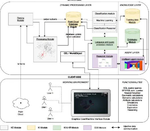
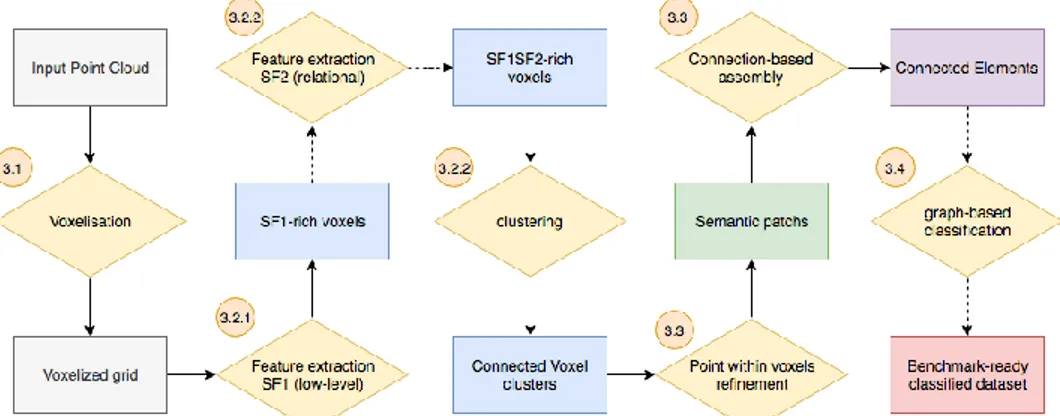
It provides all the necessary information for the development of an infrastructure to (1) handle point cloud data, (2) manage heterogeneity, (3) process and group points that retain a relationship (4) regarding a specific domain ontology and (5) that allow to query and reason for (6) providing a decision-making tool (7) including smart modelling. The thesis is structured in 7 chapters (including Chapter 1: Introduction and Chapter 7: Conclusion), each giving extended details on the proposed Smart Point Cloud Infrastructure showed in Figure 5.
Figure 5. The Smart Point Cloud Infrastructure and its modular architecture associated to the thesis chapters.
Chapter 2 gives an overview of the most in-use point cloud workflows from acquisition to delivery. I first provide a comprehensive list of applications associated with used sensors and platforms. This introduces the main challenges by giving data-driven specificities linked to reality-capture devices, followed by problematics to structure & represent such datasets. Then, I address automation fundamentals and related limitations. The sections are voluntary succinct to give the reader a quick and structured outline with references to pertinent works if one wants more details. While this chapter doesn’t participate into new research breakthrough, it is essential to the good comprehension of the thesis and to develop a full understanding of the motivations behind the formulated hypothesis.
Chapter 3 details the proposed Smart Point Cloud (SPC) Infrastructure for a modular and centralized point cloud framework. It provides a conceptual data model to structure 3D point data, semantics and topology proficiently. It aims at creating a point-based digital twin usable by Cognitive Decision Systems. A multi-modal infrastructure integrating this data model is presented that includes Knowledge Extraction, Knowledge Integration and Knowledge Representation for automatic agent-based decision-making over enriched point cloud data. It constitutes the backbone of the thesis, and its modular nature permits efficient extensibility to several applications. Each module is then described in following chapters, giving the
details of their specificity and their role toward interoperable digital reality. This chapter is based on the book chapter “A Smart Point Cloud Infrastructure For Intelligent Environments” [2] to be published in 2019 in ISPRS Book Series.
Chapter 4 develops the parsing module to best integrate point cloud data within the SPC Infrastructure while managing efficiently source heterogeneity. The chapter gives extended details on a voxel-based feature engineering method followed by an unsupervised segmentation approach that is used to better characterize point clouds and integrate them within automated workflows. The parser is also extendable through domain related classifications illustrated in the chapter. Algorithms, methods and metrics are given to benchmark the approach against best-performing deep learning mechanisms. This chapter is based on the article “Voxel-based 3D point cloud semantic segmentation” [3] to be published in 2019 in the Open Access ISPRS International Journal of Geo-Information.
Chapter 5 illustrates the flexibility of the SPC parser by plugging a formalized knowledge classifier for multi-sensory data. The chapter presents a domain-based mechanism exemplifying Knowledge Extraction, Knowledge Integration and Knowledge Representation over point cloud data in the context of archaeological research. As such, I give an exhaustive review of point cloud integration within archaeological applications and related 3D GIS. An acquisition, pre-processing, and ontology-based classification method on hybrid point clouds is proposed leveraging the SPC Infrastructure. It also proposes a web-based prototype for the visualisation of complex queries. It provides an example of ontology-based classification as a module while demonstrating the possible interactions with a 3D semantic representation. It is based on the paper “3D point cloud in archaeology” [4] published in 2017 in the Open Access journal Geosciences.
Chapter 6 shows the possibility to attach domain-specific agent-based modules to provide automated inferences. It presents an integrated 3D semantic reconstruction framework that leverages segmented point cloud data and domain ontologies. The approach follows a part-to-whole conception which models a point cloud in parametric elements usable per instance and aggregated to obtain a global 3D model. SPC heuristics, context and relationships are used to deepen object characterization. Then, it proposes a multi-representation modelling mechanism augmented by automatic recognition and fitting by massive 3D data mining. Its conception permits a direct integration within the landscape of 3D data by providing an interoperable way to map point clouds with other 3D representations. This chapter is based on the article “3D point cloud semantic modelling” [5] published in 2018 in the Open Access journal Remote Sensing.
Chapter 7 concludes the thesis with the key takeaways and answers the research questions by summarizing the main contributions of the research. Finally, I propose a roadmap for future work by giving research questions that were raised by doing this research.
CHAPTER
2
Chapter 2 - Background ... 27 2.1 Applications & Industries ... 29 2.2 3D point cloud data specificities ... 32 2.3 Representation & structuration ... 34 2.4 Automation ... 37
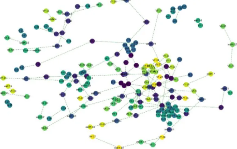
The dissertation is inspired by previous works gradually presented along chapters 2, 3, 4, 5 and 6 following Figure 6. These references are introduced in the second section of each chapter and organized to fit its content. Figure 6 acts as a point of reference to identify where the most pertinent state-of-the-art resources can be found and to help the reader navigate the essay.
Figure 6. State-of-the art resources given in the thesis. It is gradually organized to first present point clouds specificities and challenges in Chapter 2, then decomposed in Chapter 3 regarding Knowledge Extraction, Integration and Representation further specialized toward
automation and structural tasks.
Every addressed topic is related to 3D point clouds which we present in the current Chapter 2. We believe that the more we dive into digital processes, the more important it is that we keep a link to real-world applications. Thus, to understand the potential of point clouds, it is central to overview main applications (2.1) and the challenges that limit a broader use. We categorized these challenges by first giving data-driven specificities linked to reality-capture devices (2.2). Then we list the main problematics we face to structure & represent such datasets (2.3) and finally we address automation fundamentals. These subsections are voluntary succinct to give the reader a quick and structured overview with references to pertinent works if one wants more details.
2.1 APPLICATIONS & INDUS TRIES
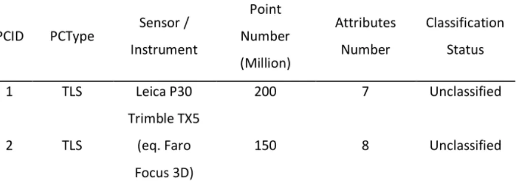
The way digital disruption is affecting industries changes the practices and creates new applications every day. Reality capture and 3D point clouds are part of these disruptive technologies, which permits the creation of spatial datasets at various scales. This rich information then serves industries such as surveying and engineering; buildings and architecture; public safety and environmental issues; heavy construction, power and plants; transportation and navigation; mining and natural resources; environmental and man-made structures monitoring. Their utility is found at many levels and seeing the number of in-use application gives a good idea of the potential they hold. We list in Table 1 the main applications from these industries categorized by sensor-related scale.
Scale/Sensor Main applications Object-scale
TrLS1, TPHO2
Molecular density, target identification, free-form component inspection, reverse-engineering, manufacturing documentation,
quality control, gaming asset creation
Building-scale TLS3, HHLS4,
TPHO
Structural deformation, BIM, 3D mapping, architectural analysis, gaming asset/environment creation, façade inspection, built environment, space optimization, construction progress monitoring,
deformation control, coordination, reconstruction, restoration, conservation, asset management, offsite production, navigation maps,
robotics, ship build documentation, facility management, planning technical modifications
Area-scale TLS, BMLS5,
APHO6
Crime-scene investigations, site mapping and discovery, virtual tours, 3D designs, forensics, agriculture, bullet-path reconstruction, fire
investigation, security and pre-planning, volume calculation Street-scale
TLS, BMLS, MLS7, APHO
Roadway design, infrastructure (bridge, railway …) inspection, parking utilization, corridor mapping, traffic congestion, road signs
and utility management, forensics and accident investigations, passive safety of cars, autonomous vehicles and self-driving cars. City-scale
APHO, MLS, ALS8
Gaming environment creation, urban survey, light simulations, airport infrastructures, utility planning, vulnerabity studies, earthquake damage assessment, cellular network planning, solar energy planning, tourism and park management, urban planning, 3D
cadaster, building classification
Region-scale ALS, APHO
DEM, DTM, DSM, Micro-topography, Forestry, environmental monitoring (land, glacier, coastline, dune, windfarm, shoreline,
change detection …), agriculture, flood/pollutant modelling, ecological and land classification, mapping, meteorology, geology, astronomy, topographical mapping, tsunami prediction, mining, oil
and gaz exploration
Table 1. Applications making use of reality-based point cloud data organized by looking at the scale of the studied environment.
From this high number of applications today in use, one is particularly interesting for its numerous challenges: self-driving cars. These are equipped with various LiDAR sensors [6] which work as a “powerful” eye for the autonomous vehicle: an eye that allow one to see in all directions all the time. Imagine if, instead of guessing, we could always know the precise distance of objects in relation to us. LiDAR enables a self-driving car to view the surroundings with these special “powers”. These are a big research motor allowing sensor mapping for guidance systems. Gerla et al. [7] state that “Vehicles will be a distributed transport fabric capable to make its own decisions about driving customers to their destinations”. This statement hides big challenges: It demands massive automation for object
1 Arm/Triangulation Laser Scanner 2 Terrestrial photogrammetry 3 Terrestrial Laser Scanner 4 Hand-held Laser Scanner
5 Backpack-Mounted Laser Scanner 6 Aerial Photogrammetry
7 Mobile Laser Scanner
detection while managing highly dimensional data from heterogenic sources. This implies looking into big data practices and data mining principles to correctly handle the volume, the velocity, the veracity and the variety of information.
The same problematics are found in scene understanding applications, a well-established research area in robotics [8]. Tasks like navigation, grasping or scene manipulation is essential to its applications, and depth sensors [9] are highly used to create environment in which robots can evolve and interact. The rapidly growing interest for UAV-based solutions [10] has made passive sensors such as thermal, infrared and RGB camera a common tool for creating point cloud via photogrammetry [11] and computer vision implementations [12]. On the industry side, new software based on Structure from motion [13] and multi-view stereo with bundle adjustment and SIFT, SURF, ORB, M-SURF, BinBoost descriptors [14,15] allowed a wide range of professionals and non-expert to recreate 3D content from 2D poses [16–25]. Use cases range from object-scale reconstruction to city-scale reconstruction, making this technique a promising way to get 3D point clouds. However, While reconstruction precision for middle to large scale are getting increasingly better [26], remote sensing via active sensors is favoured in several infrastructure-related industries.
Also mentioned in the Table 1, active triangulation, structured light and computer tomography for reverse engineering and modelling is highly used at the object-scale due to its high precision, and adaptation to small isolated objects [27]. Typically, deviation analysis and prototyping will be based on the point cloud acquired, and parametrization tasks will convert the point cloud to a mesh interpolation [28], or solid parametric geometry. To some extents, ALS point cloud processes relates closely to the same pipeline for mesh generation, specifically DTM, DSM and DEM. In both techniques, a critical step includes layering data, therefore classifying to obtain correct representations. I.e., the generation of a DTM needs to take into account only points belonging to what is considered “ground” [29], which present major automation challenges. Applications are numerous especially to map regions (corridor, roads, railway, landscapes), for product extraction, forest and coastal management, flood mapping, volume calculation, 3D city models creation for urban planning, glacier monitoring and other region-scale measurement’s extraction listed in Table 1. This can be further refined using the full-waveform LiDAR data [30] providing better structural and physical information within the backscattered signal of the illuminated surface, allowing new data analysis and interpretation. Some Terrestrial Laser Scanners (TLS) also propose full waveform processing, and an example of application to determine canopy height is given in [31].
TLS have driven an engagement within manufacturers including Trimble, Topcon, Faro, Maptek, Optech, Riegl, Zoller + Fröhlich, Smart Max Geosystems, Neptec Technologies, TI Asahi, Clauss, Leica, focusing on Phase Based and Time of Flight technology [32] enabling different use cases depending mainly on the desired precision, the range and resolution of the point cloud. Topography, indoor mapping,
AEC, monitoring, reconstruction, archaeology, cultural heritage conservation benefits of the high precision and versatility laser scanners offers. The high speed and rate generation of 3D points has become a convenient way to get instantly data, constituting datasets of up to Terabytes, so redundant and rich that control operation can take place in a remote location. However, it is still rare that point clouds are directly shared or used as an end-product. Rather, they are interpreted and analysis reports, simulations, maps, BIM and 3D models will be considered as deliverables. Rising from the static concept, Mobile Laser Scanning (MLS) [33] has scaled up the data rate generation of TLS by allowing dynamic capture allowing rapid street point cloud generation and public domain mapping. New concepts and technology including Solid State LiDAR and simultaneous localization and mapping (SLAM) has pushed dynamic acquisition for quickly mapping the surroundings, extending cases for indoor mapping using Hand-held Laser Scanners HHLS [34], Mobile Mapping Systems (MMS) [35], or more recently Backpack-mounted Laser Scanners (BMLS) [36].
While 3D point clouds are well-established as a source of spatial data, we often note that they are not the preferred default data type in the industry, mainly due to data specificity and structuration problematics. On top, both these characteristic and the variety of domain complicate automation workflows which industries aim to increase reliability and efficiency in established workflows.
2.2 3D POINT CLOUD DATA SPECIFICITIES
Despite the ease of capturing point clouds, processing them becomes a challenging task in part due to the problems listed Table 2. Indeed, point clouds obtained from the sensors described in sub-section 2.1 suffers mainly several artefacts (Table 2). These are the main data-driven obstacles to a wider dissemination, often related to their data-structure or capture-related environment specificities. The structure-related problems usually emerge due to a lack of connectivity within point ensembles, which can make the surface information ambiguous [37]. Furthermore, environment-related problems are usually present in real world acquisition setup which happens due to different reasons such as limitations of the sensors or some physical factors in the scene.
Artefact Main source Misadjusted
density
Point clouds exhibit locally variable densities based on surface orientation, nature and distance from the capturing device. Occlusions
from surface irregularities and adjacent objects also produce regions with missing data. Variations in density can be attenuated by
sub-sampling techniques but not fully eliminated. Clutter
A scene can contain small objects represented by very few points, moving objects and multiple objects in proximity which for an application are considered “noise”. These are often making feature
detection, structuration and automatic recognition difficult.
Occlusion
A scene can contain objects of significant size that occlude objects behind them (E.g cars, buildings…). This produces incomplete and disjointed descriptions of the background surfaces thus large missing areas. This phenomenon can be limited through an adapted acquisition
technique, E.g. reduced using BMLS, MLS, MMS or HHLS systems compared to static devices.
Random errors (noise)
This is mainly due to absorption linked to the operation frequency, scattering, and taking into account the properties of the observed object + the wavelength of the incident energy. These influence the sensor’s choice considering the application, firstly between active and passive sensors. As passive sensors rely solely on the light emittance of
the measured object, they are more influenced by atmospheric conditions and errors.
Systematic errors
The sensor will measure a property in the scene, and to be highly representative, must be sensitive to only the value measured, without
influencing the backscattered signal. However, errors such as zero input, sensitivity error will create additional noise, but these can be
calibrated. Surface
properties
The physical texture of common surfaces can range from smooth (steel, marble) to very irregular (grass, crushed stone). Because a given scene can contain a wide range of surface roughness’s, no priors
about noise levels can be reliably used.
Misalignement (i.e. georeferencing
errors)
Assembling point data in one reference system is a task that is primarily dependent on the acquisition platform (airborne, vehicle,
tripod, satellite). Indeed, the data obtained by different LiDAR platforms are heterogeneous in three respects: (1) different perspectives: data collected by space-based laser scanning (SLS) and airborne laser scanning (ALS) systems are from a top view, while data
collected by MLS or TLS systems are from a side view; (2) different spatial resolution: the resolution of ALS data is generally at the meter
scale, while MLS and TLS data are at the centimeter scale, with TLS being more precise; (3) different content of focus: ALS data cover
general features, while MLS data cover both trajectory sides. Furthermore, registration can introduce local noise due to imperfect
correspondence between point clouds.
Table 2. Artefact commonly found in reality-based 3D point clouds. These are obstacles to a broader adoption of point cloud data as the default spatial data type.
As referred in [38], these artefacts produce missing and erroneous (noise, outliers, misalignment) data, which can arise from an improper set-up on the scene. It also happens when the surface doesn’t permit a correct survey thus return an incomplete dataset. E.g. transparent and very reflective surfaces will produce unpredictable data. Objects like windows, mirrors, and shiny metal frames or ducts can generate either no-points associated to them, or worse, points on virtual reflected surfaces that place the object at a false location in space. Filtering techniques and knowledge based-interpretation are possible solutions to these problems to get the most complete description of the scene. Complementary, getting a high number of representative signal descriptors and parameters for each point permits a more reliable description important for automation through segmentation, classification and domain adaptation.
2.3 REPRESENTATION & STRUCTURATION
The 3D datasets in our computerized ecosystem – of which an increasing number come directly from reality capture devices presented in 2.1 – are found in different forms that vary in both the structure and the properties. Interestingly, they can be somehow mapped with success to point clouds thanks to its canonical nature. We provide a quick review of the main 3D data representations modes bindings to point clouds and we invite the reader to study [39–42] for more details.
First, point clouds can be mapped to shape descriptors [43,44]. These can be seen as a signature of the 3D shape to provide a compact representation of 3D objects by capturing some key properties to ease processing and computations. The nature and the meaning of this signature depend on the characteristic of the shape descriptor used and its definition. For example, global descriptors provide a concise yet informative description for the whole 3D shape while local descriptors provide a more localized representation for smaller patches in the shape. The work of Kazmi et al. [43], Zhang et al. [44] and more recently Rostami et al. [45] provide comprehensive surveys about such 3D shape descriptors.
Secondly, projecting 3D data into another 2D space is another representation for raw 3D data where the projected data encapsulates some of the key properties of the original 3D shape [46]. Multiple projections have been proposed in the literature where each of them converts the 3D object into a 2D grid with specific features. Projecting 3D data into the spherical and cylindrical domains (e.g. [47]) has been a common practice for representing the 3D data in such format. Such projections help the projected data to be invariant to rotations around the principal axis of the projection and ease the processing of 3D data due to the Euclidean grid structure of the resulting projections. However, such representations are not optimal for complicated 3D computer vision tasks such as dense correspondence due to the information loss in projection [48].
Third, representing 3D data as RGB-D images has become popular in the recent years thanks to the popularity of RGB-D sensors. RGB-D data provides a 2,5D information about the captured 3D object by attaching the depth map along with 2D colour information (RGB). Besides being inexpensive, RGB-D data are simple yet effective representations for 3D objects to be used for different tasks such as identity recognition [49], pose regression [50] and correspondence [49]. The number of available RGB-D datasets is huge compared to other 3D datasets such as point clouds or 3D meshes [51] but they do not permit a direct 3D immersion.
Fourth, 3D data can be represented as a regular grid in the three-dimensional space. Voxels are used to model 3D data by describing how the 3D object is distributed through the three-dimensions of the scene. Viewpoint information about the 3D shape can be encoded as well by classifying the occupied voxels into visible, occluded or self-occluded. Despite the simplicity of the voxel-based representation it suffers from some constraining limitations [52]. Voxel-based representation is not always efficient because it represents both occupied and non-occupied parts of the scene, which can create an unnecessary demand for computer storage. More efficient 3D volumetric representations are often linked to indexing techniques addressed later.
Fifth, we can access 3D information from a multi-view image, which is a 2D-based 3D representation where one access the information by matching several 2D images for the same object from different point of views. Representing 3D data in this manner can lead to learning multiple feature sets to reduce the effect of noise, incompleteness, occlusion and illumination problems on the captured data. However, the question of how many views are enough to model the 3D shape is still open, and linked to the acquisition methodology for photogrammetric reconstructions: a 3D object with an insufficiently small number of views might not capture the properties of the whole 3D shape (especially for 3D scenes) and might cause an over-fitting problem. Both volumetric and multi-view data are more suitable for analysing rigid data where the deformations are minimal.
Sixth, 3D meshes are one of the most popular representations for 3D shapes. A 3D mesh structure consists of a set of polygons called faces described in terms of a set of vertices that describe how the mesh coordinates exist in the 3D space. These vertices are associated with a connectivity list which describes how these vertices are connected to each other. The local geometry of the meshes can be realized as a subset of a Euclidean space following the grid-structured data. However, on a global aspect, meshes are non-Euclidean data where the familiar properties of the Euclidean space are not well defined such as shift-invariance, operations of the vector space and the global parametrization system. 3D meshes can also be presented as graph-structured data where the nodes of the graph correspond to the vertices of the mesh and the edges represent the connectivity between these vertices.
(a) (b) (c) (d) (e) (f) Figure 7. 3D data representation: (a) point cloud; (b) multi-view image; (c) depth map; (d)
volumetric; (e) polygonal mesh; (f) parametric model.
Thus, the versatility given by point cloud mappings to 3D representations modes is very interesting and permits to leverage the strength of several approaches. However, this demands that we study ways to integrate point clouds directly in computerized systems.
This is a major challenge as the large discrete datasets that point clouds constitute cannot directly fit in the main memory. Handling efficiently these massive unstructured datasets (heterogeneous and from different sources) demands high scalability, speed (when data must be mined in a near or real-time style) and computational adaptation to answer specific needs.
This again relates to Big Data problematics, or how to efficiently process big semi-structured / unstructured datasets. relational Database Management Systems (DBMS) and NoSQL DBMS for such application provide interesting research tracks which are further explored in this thesis. The fundamental component in DBMS is the data model that determines the logical structure of a database determining in which manner the data can be stored, organized, and manipulated. We refer to the extensive works of Otepka et al. [53], Van Oosterom et al. [54] and Cural et al. [55] which provides fundamentals over existing large point cloud data structures including attribute and geometrical information organization. They rightfully state that the secondary storage access limits data-intensive tasks that could be solve through streaming algorithms to keep small parts in-memory. However, this implies pre-sorting and structuring a priori the data to handle the large volume and high resolution, thus linked to indexations problematics.
Indexation for 3D point clouds via spatial indices that subdivide the space through different approaches are a solution to reduce the overhead via chunk memory loading. The exhaustive paper presented by [56] state that the spatial subdivision of k-d tree are not suited for updates (e.g. add, remove) operations over point clouds because the tree structure becomes unbalanced. However, k-d trees perform well regarding Nearest-Neighbor searches by efficiently eliminating large portions of the search space (≈ 0(log n)). Octree structures, a 3D analogy of quad-tree [57], as opposed to kd-quad-tree perform well for update operations thanks to their uniform spatial subdivision, which makes them particularly interesting considering point cloud varying resolution, distribution and density. Linked to voxelized
representations, an octree [58] is a tree-like data structure that models occupancy by dividing a 3D scene [56] into multiple hierarchical cubes. They are powerful in representing the fine details of 3D scenes compared to voxels with less computations because of their ability to share the same value for large regions of space. However, as stated by [59] , octrees are “not able to dynamically adjust the tree structure according to the actual object layout. As a result, the tree depth is high where there are many objects, and this also results in unstable query performance”. Other interesting work such as 3D R-Tree [60], modified nested octrees or sparse voxel octrees [61] are also solutions for spatial data indexing techniques.
Point clouds are thus good candidates for Level of Detail (LoD) implementations for a better management (and rendering) of the data. But to be usable in extended workflows, ways to map semantics and domain knowledge to point clouds are to be addressed. A good introduction to knowledge injection within 3D scenes is accessible in [62]. The authors structure knowledge information in formal domain ontology [63], which could then be accessed through different queries. Formal ontologies thus are a great research track for leveraging domain specificities, but their integration with data artefacts and data structure is very manual. By extension, the extraction of knowledge from gathered data suffers from automation problematics that are very important obstacles to the usability and efficiency of point clouds within workflows.
2.4 AUTOMATION
The concept of 3D point cloud automation is found at different stages, illustrated in Figure 8 presenting a classical workflow.
Figure 8. Classical point cloud workflow from acquisition to delivery of a product for a specific application.
While automation for the acquisition of point clouds, pre-processing and registration opens multiple research tracks, we focus in this dissertation on segmentation, classification, structuration and application-related automation. However, the reader can find further information regarding the acquisition phase automation which mainly deals with capturing platforms [64], such as UAVs [10], multi-sensory robots [65] and efficient navigation systems [66]. For the pre-processing stage which mainly deals with filtering techniques to avoid sensor-related problematics and for calibrating devices, we refer to the work of Kaasalainen et al. [67]. As for the registration step, we refer to feature-based and featureless automatic registration methodologies reviewed in [68,69], SLAM reviewed in [70] and dense-matching in [15,71].
Automation in detecting objects by grouping points that share a similarity and decisive criterion is the basis for segmentation, thus classification. This step is crucial since accuracy of the subsequent processes depends on the validity of the segmentation results [72] and requires to balance flexibility with the ease of use. As point cloud sets get larger, segmentation methods need to be scalable in terms of time and memory complexity. Special attention needs to be paid to offline processes – that can be run over night without user supervision – and online responsive processes that leverage user interaction and geared toward real-time applications. State-of-the-art segmentation and classification applied to point cloud references are reviewed in [73], and deep learning techniques for semantic segmentation in [74]. It is important to note that the major challenges concern the domain specialization, which will majorly orient a classification approach. Classifiers that learn from previous or available knowledge differ from their approach, thus their results. They are usually categorized in 3 ensembles as in being supervised learning (from a set of features to a labelled data) unsupervised learning (structure detection by pattern recognition) and reinforcement learning (functional inference through a set of state and actions). While supervised method often proves more efficient than its unsupervised analogue, they can suffer from over-fitting which limits their extensibility and interoperability with wider applications. This is a main concern for massive automation, and it is tackled in the dissertation. Several approach demands a feature selection and engineering among the most in-use 3D descriptors reviewed in [75], which permit to extract a fine-tuned description of the underlying data. However, it is important to note that in point cloud classification frameworks and feature estimation, the suitability of features should privilege quality over quantity [76]. This shows a need to prioritize and find robust and relevant features to address the heterogeneity in a point cloud structure. Several approaches make use of Decision-trees [77], Random Forests (RF) [78] extended to Streaming Random Forests [79], Support Vector Machines (SVM) [80], Conditional Random Fields (CRF) [81], Neural Networks [82,83] and multiple variants [39,45,91–93,83–90].
As stated by [94] “any fully-fledged system should apply as much domain knowledge as possible, in order to make shape retrieval effective”. With the rise of online solutions, there is a great potential in using formalized knowledge for classification to analogically associate shapes and groups of points with similar features. This association through analogy “is carried out by rational thinking and focuses on structural/functional similarities between two things and hence their differences. Thus, analogy helps us understand the unknown through the known and bridge gap between an image and a logical model” [95]. This introduces the concept of data association for data mining, and relationships between seemingly unrelated data in an information repository. The use of domain knowledge over point cloud data by separating domain knowledge from operational knowledge refers to ontologies, although knowledge-based applications do not always refer to ontology reasoning. These concepts orient research in structural and application-related automation for a more interoperable and generalizable framework. Some attempt
were made such as in [96] to turn a kitchen point cloud into a meaningful representation for robot interaction; [97] developing an interesting web object recognition workflow; [66] tackling robot-vision understanding and navigation challenges by proposing an abstracted spatial hierarchy graph and a semantic hierarchy that model domain concepts. Overall, attaching semantic concepts to point clouds for further reasoning was attempted in several disciplines but never generalizable. On top, some propose a way to infer knowledge in segmentation and classification method, papers rarely cover the topic of data structuration. To keep a record and use ontologies over analysis process, the point cloud needs to be structured retaining spatial and relation information deducted or useful for classification and segmentation. For data visualisation, it is also very important to work over a structure as flexible as possible to handle billions of records and queries over different attributes for validation through visual perception.
It appears that 3D data capture workflows would benefit from semantically rich point cloud in order to automate reasoning for an application, end-point of Figure 8. Using connectivity, material properties, date stamp or even description of chunk-wise group of points can be useful in almost all scenarios, even for mesh derivation. Managing highly dimensional data and heterogenic sources therefore goes through the definition of efficient automated procedures that describe the nature and properties of a point cloud sample in order to classify and establish relations between point segments in a new data structure.
CHAPTER
3
Chapter 3 - A Smart Point Cloud Data Structure... 42 Chapter’s preface ... 45 3.1 Introduction ... 48 3.2 Semantics & 3D Data ... 50 3.2.1 3D spatial information systems ... 50 3.2.2 Knowledge integration solutions for 3D semantically-rich data... 51 3.2.3 Point cloud solutions for knowledge integration ... 53 3.3 The Smart Point Cloud (SPC) Data model ... 55 3.3.1 Knowledge categorization ... 55 3.3.2 Conceptual SPC (Smart Point Cloud) Model... 56 3.3.3 Level-0: Generalized SPC meta-model ... 58 3.3.4 Level-1: Connection-layer meta-model... 60 3.3.5 Level-2: Domain adaptation... 62 3.4 Framework articulation & automation for intelligent environments ... 63 3.4.1 Infrastructure modularity and extensibility ... 64 3.4.2 SPC Requirements benchmarking ... 69 3.5 Limitations, Perspectives and possibilities ... 74 3.6 Conclusion ... 75
CHAPTER’S PREFACE
In this chapter 3, I will give the necessary details for the realisation of a Smart Point Cloud Infrastructure. The main element is the conceptual data model which permits the structuration of the Point Cloud Database Module as highlighted in Figure 9.
Figure 9. Chapter 3: A Smart Point Cloud Data Structure
Details about the integration and compatibility of each module are also given. This chapter lays the groundwork to comprehend how every subsequent module described in chapters 4, 5 and 6 interact, and permits to get a precise understanding of the proposed framework.
Based on Book Chapter
[2]A Smart Point Cloud Infrastructure for intelligent
environments
Abstract: 3D Point cloud data describes our physical world spatially. Knowledge discovery processes including semantic segmentation and classification are a great way to complement this information by leveraging analytic or domain knowledge to extract semantics. Combining efficiently these information’s is an opening on intelligent environments and deep automation. This chapter provides a conceptual data model to structure 3D point data, semantics and topology proficiently. It aims at creating an interactive clone of the real world usable by Cognitive Decision Systems. A multi-modal infrastructure integrating this data model is presented that includes Knowledge Extraction, Knowledge Integration and Knowledge Representation for automatic agent-based decision-making over enriched point cloud data. A knowledge-base processing with ontologies is provided for extended interoperability.
Keywords: 3D Point Cloud, Intelligent Support Systems, 3D Database, Segmentation, Classification, Structure, Ontology, Semantics, Cognitive Decision.
To be published in 2019 Type: Open Access Article Publisher: Taylor and Francis Serie: ISPRS Series Book name: Laser scanning: an emerging technology in structural engineering
3.1 INTRODUCTION
Knowledge extraction (KE), also known as Knowledge Discovery Process [98,99] is the process to mine9 information and create new knowledge from structured / unstructured data. Specifically, KE-oriented processes such as semantic segmentation and classification permit to extract relevant information regarding an application domain. However, KE is only one step from a global pipeline that aims at creating an interactive space for autonomous decision-making: to represent the world in a form that a computer can use to reason (Figure 10).
Figure 10. Modular Framework for the creation of an intelligent virtual environment, illustrated over an Indoor Point Cloud. (1) KE; (2) Knowledge Integration; (3) Knowledge
Representation; (4) Reasoning from Cognitive Decisions Layer (CDL)
Looking at this modular framework from raw data to Intelligent Environment [100], the processes of integrating, structuring, reasoning and interacting with the data are very challenging especially when dealing with massive datasets from heterogeneous sources. In this chapter, we explore a solution driven by a need in automation (Figure 10) to progressively achieve fully autonomous cognitive decision-making based on 3D digital data.
State of the art in KE-automation applied to point clouds permits nowadays to efficiently extract different information’s by means of feature-based algorithms [76] , by using Knowledge-based inference [4] or more actively through machine
9 The purpose of data mining is to extract knowledge from large
amounts of data using automatic or semi-automatic methods.
learning10 with promising results using neural networks [90,91,101–105] and decision trees [106]. Extracted knowledge often comprises new patterns, rules, associations or classifications and is ultimately useful for one application. But adapting this extra information to be usable within various domains is a great interoperable challenge. A transversal field coverage demands bijective communications through a great generalization and normalization effort.
The processing module defined as knowledge integration (KI) in Figure 10 specifically addresses this task of synthetizing multiple knowledge sources, representations and perspectives often layering multiple domains. This can be decomposed into (1) information integration (i.e. merging information that is based on different schemas and representation models), and (2) synthetizing the understanding of one domain into a common index that keep track of the variance within perspectives. KI specifically addresses integration and structuration of the data (often within database systems), which may resolve conflicts with hitherto assumed knowledge.
Thus, the extended data structure must be translated into an explicit Knowledge representation (KR) to permit a computer to achieve intelligent behaviour, and access knowledge reasoning through a set of logical and inference rules. This is very motivating if you want to deepen the operations made by the computer rather than interpreting on the fly (brain work). Once metadata is attached to 3D data, then you can more easily grasp, or even make calculations impossible before (e.g. in Figure 10 for 3D indoor pathfinding, indoor lighting simulations, reasoning for optimal positioning, extraction of surfaces per room for digital quotations and inventories).
While such a universal solution to decision-making situation is very attractive, KE, KI and KR highly depends on the initial application domain definition, data understanding and its integration within a complete infrastructure. This strains that the underlying data structure must synthetize knowledge through pertinent KR while permitting inference reasoning based on an efficient Cognitive Decision Layer (CDL).
In a first part, we study the attempts, standards and existing reflections to define a common scheme for exchanging relevant 3D information while situating the current integration state of point clouds within these normalizations. Secondly, we present a data model for point cloud structuration that retains knowledge. We then propose a point cloud infrastructure integrating this data model to allow KE, KI and KR following the modular framework presented in Figure 10. Finally, we benchmark such a global solution against several datasets to test its response to established requirements and identify limitations for new research directions.
10 supervised / semi-supervised / unsupervised
3.2 SEMANTICS & 3D DATA
In the context of 3D data, the wide array of applications implies a vast diversity on how the data is used/conceived. This research environment adds important complexities to the integration within any generalized workflow, of which 3D point cloud data are quasi-inexistent. This explicitly demands that data-driven applications enable targeted information extraction specific to each use case. While this is rather convenient for one use case, making a general rule that applies to all models is a daunting task. In this section, we review existing attempts and standards favouring interoperability through well-established 3D spatial information systems (3.2.1), KI reflexions over 3D data (3.2.2) and point clouds (3.2.3).
3.2.1 3D spatial information systems
Datasets that explicitly include spatial information are typically distinguished regarding the data models and structures used to create, manage, process, and visualize the data. In a 3D context, we analogically to [107,108] differentiate three main categories:
- 3D GIS: GIS systems usually model the world itself, retaining information about networks, conductivity, connectivity, topology, and associativity. This enables geospatial analysis, often carried on large collections of 3D instances stored in data warehouses with coordinates expressed in a frame of reference.
- 3D CAD (Computer Aided Design): CAD/CAM techniques model objects from the real world through parametric and triangular modelling tools. The topology is often partial or planar (although vendors extend functions to include semantics and higher descriptive topology [109]) and the data usually plays on a visual scale. The distinction between visualisation and storage is not as clear as in 3D GIS systems, and one file generally describes one complex 3D object. CAD files carry visualization information that is not relevant to the data itself. A simplistic difference consists in thinking of 3D GIS systems as 3D spatial database whereas 3D CAD models are rather related to 3D drawings. The coordinate system is therefore linked to a defined point of interest (often the centroid) in the scene.
- BIM: it constitutes working methods and a 3D parametric digital model that contains “intelligent” and structured data initially for planning and management purposes. It is often studied for its integration with 3D GIS systems with an extensive review in [110], but their parallel evolution (conditioned by temporal and hermetic domain research) and fundamentally different application scopes are slowing down their common assimilation. BIM models share many properties with 3D CAD models,