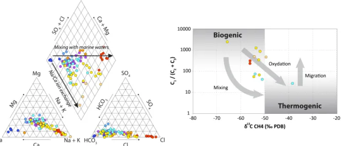
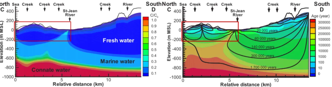
Understanding shallow and deep flow to assess the risk of hydrocarbon development on groundwater quality.
Texte intégral
Figure


Documents relatifs
The evolutionary history of the taxa in X can then be represented by a rooted phylogenetic network N on X where the tree nodes correspond to speci- ation events and the reticulate
This work presents a simple but highly expressive type-system that is sound and complete with respect to the class of polynomial time computable functions, that can be checked
Our results indicate that the ability of BALB mice to survive the early-onset liver disease can be primarily attributed to lower levels of RVFV in the blood and liver and lesser viral
However, Gaufin et al [48] found no significant effect of B cell depletion on viral load in SIV infection in African Green Monkeys, concluding that humoral immune responses play only
Il devient l’ami du pianiste accompagnateur Jacques Fray, ancien de chez Koechlin, il rencontre André Schaeffner (qui avant sa carrière d’ethnologue de la musique au musée
Mais à peine Porsenna et Galerite eurent-ils le loisir de connaître leur bonheur, qu'ils eurent une douleur extrême ; car la sage et prudente Nicétale mourut peu de temps après
Sex differences in digit ratio (A) and mental rotation score (B). Error bars represent SE. Heading error in all-directional and all-positional cue environments. Error bars
- L'équilibre de l'ensemble devra être maintenu par une position fixe qui limitera tout mouvement du buste vers l'avant au juste nécessaire, (ce sont les mains et les
